This item has been sold, but you can get on the Waitlist to be notified if another example becomes available, or purchase a digital scan.
1933 Lindgren 'Hysterical' Map of Mount Rainier National Park, Washington
MountRainier-lindgren-1933$1,000.00

Title
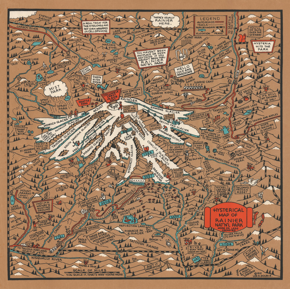
Hysterical Map of Rainier Nat'n'l Park More or Less Cockeyed.
1933 (dated) 19.25 x 19.25 in (48.895 x 48.895 cm)
1933 (dated) 19.25 x 19.25 in (48.895 x 48.895 cm)
Description
This is the only known surviving example of one of the Lindgren Brother's earliest 'Hysterical Maps', their 1933 pictorial map of Mount Rainier. It is one of just 9 maps issued by the Lindgren Brothers using an ad hoc silkscreen technique they pioneered in-house - all of the Lindgren Brothers' rare screen-printed maps are striking for their rich color. After their first map in 1932, the Lindgren Brothers produced just four more maps in 1933, all copyrighted by local advertising agent Lee R. Double, likely a client of their sign-painting business.
Lindgren's earliest maps used this method and were printed on unusual, long-fiber, brownish paper. These include the first of Spokane County (1932), four subsequent 1933 maps issued in partnership with local advertising agent Lee R. Double (Eastern Washington County, Puget Sound County, Mount Rainier, and Olympic Peninsula and Puget Sounds Country), Yellowstone (1934,where the distinctive blue border was introduced), and Jackson Hole (1935).
The use of silkscreen printing on Lindgren's initial map productions introduced elements that became synonymous with Lindgren's style - bold colors, simple print blocks, and thick lines.
Their first map, titled Hysterical Map of the Spokane Country Slightly Cockeyed, was screen printed in 1932. As the name suggests, it was designed to entertain rather than inform, aiming more for humor than historical accuracy. The map's popularity led to additional titles in 1933, all in partnership with local advertising man Lee R. Double: Eastern Washington County, Puget Sound County, Mount Rainier, and Olympic Peninsula and Puget Sound Country. Then, in 1934, they issued their groundbreaking Yellowstone National Park, the first to feature their trademark blue border.
Although the Great Depression strained many industries, national park tourism flourished. The Lindgren Brothers successfully tapped into this market by offering humorous, souvenir-style maps to eager visitors. Starting with the 1934 Yellowstone release, Jolly introduced a consistent visual template that became his hallmark: a bold blue (or red) border featuring the title, yellow to represent land (a nod to Yellow-stone), red for roads, black for labels, and touches of green and blue to accent the illustrations.
In 1930, the Lindgrens brought on Theodore 'Ted' Turner, Jr. (1902 - 1989) as sales director - it was Turner's clever idea to change the name of their 'slightly cockeyed' maps from 'Historical' to 'Hysterical'. Over the years, his involvement deepened, and by 1949, he became a full partner, and the company was renamed Lindgren-Turner.
Following World War II, as interest in humorous maps declined, the team pivoted to producing souvenir decals, which proved extremely popular. After Jolly Lindgren's death in 1952, Oscar and Turner continued to expand the company's offerings, introducing oversized map-themed postcards branded as 'King Size Mapcards.'
A Closer Look
The map focuses on the snow-capped Mount Rainier's Columbia Crest. It is bounded by the borders of Mount Rainier National Park. The map is early in Jolly Lindgren's corpus, but it, nonetheless, already demonstrates his distinctive humor and illustration style. It does, however, predate the 1934 introduction of the distinctive Lindgren blue (later red) border work. Like his other 1932-1934 maps, it is printed on an unusual long-fibered brown paper - replaced in 1935 with more traditional white paper.Pioneering Silkscreen Printing
Lindgren's earliest maps issued in 1932-33, as here, were printed in multiple colors via photographic multi-layered silkscreen stencils, a laborious process that, while they did not invent, they did pioneer. (Ott Lindgren was likely introduced to the technique while serving in Europe during World War I). According to business partner Ted Turner Jr., they used Swiss sieve silk acquired from a local flower mill supply company. The paint was regular house paint, doctored to achieve the right consistency with a proprietary blend of starch, vinegar, and kerosene. The paint blend was applied in layers, with colors applied first, then black ink, each color pressed through the open stencil mesh using a squeegee blade. The result was replicable (in small numbers) prints in striking, vibrant colors.Lindgren's earliest maps used this method and were printed on unusual, long-fiber, brownish paper. These include the first of Spokane County (1932), four subsequent 1933 maps issued in partnership with local advertising agent Lee R. Double (Eastern Washington County, Puget Sound County, Mount Rainier, and Olympic Peninsula and Puget Sounds Country), Yellowstone (1934,where the distinctive blue border was introduced), and Jackson Hole (1935).
The use of silkscreen printing on Lindgren's initial map productions introduced elements that became synonymous with Lindgren's style - bold colors, simple print blocks, and thick lines.
Hysterical Maps of the Lindgren Brothers
The Lindgren brothers, based in Spokane, Washington, were known for producing lighthearted, cartoon-style pictorial maps of state and national parks. Their enterprise began as a sign painting business in 1928, with Hjalmer' 'Jolly' Lindgren serving as the illustrator and Oscar (O.S.) Lindgren managing operations and production.Their first map, titled Hysterical Map of the Spokane Country Slightly Cockeyed, was screen printed in 1932. As the name suggests, it was designed to entertain rather than inform, aiming more for humor than historical accuracy. The map's popularity led to additional titles in 1933, all in partnership with local advertising man Lee R. Double: Eastern Washington County, Puget Sound County, Mount Rainier, and Olympic Peninsula and Puget Sound Country. Then, in 1934, they issued their groundbreaking Yellowstone National Park, the first to feature their trademark blue border.
Although the Great Depression strained many industries, national park tourism flourished. The Lindgren Brothers successfully tapped into this market by offering humorous, souvenir-style maps to eager visitors. Starting with the 1934 Yellowstone release, Jolly introduced a consistent visual template that became his hallmark: a bold blue (or red) border featuring the title, yellow to represent land (a nod to Yellow-stone), red for roads, black for labels, and touches of green and blue to accent the illustrations.
In 1930, the Lindgrens brought on Theodore 'Ted' Turner, Jr. (1902 - 1989) as sales director - it was Turner's clever idea to change the name of their 'slightly cockeyed' maps from 'Historical' to 'Hysterical'. Over the years, his involvement deepened, and by 1949, he became a full partner, and the company was renamed Lindgren-Turner.
Following World War II, as interest in humorous maps declined, the team pivoted to producing souvenir decals, which proved extremely popular. After Jolly Lindgren's death in 1952, Oscar and Turner continued to expand the company's offerings, introducing oversized map-themed postcards branded as 'King Size Mapcards.'
Publication History and Census
This map was silkscreen printed by the Lindgren Brothers and copyrighted by Lee Double. It was replaced in 1940 with a new map of Mount Rainier incorporating Lindgren's later stylistic developments. (c.f. Rumsey 12319.000). The silkscreen printing technique would have limited the production of this map to very low numbers. All Lindgren silkscreen maps are exceedingly rare, and this is the only example of the present map we have traced.CartographerS
Lindgren Brothers (1928 – 1971) was a Spokane, Washington, based printer known for issuing humorous souvenir auto decals, maps, and posters. The firm was founded as a sign-painting company by Hjalmer 'Jolly' Lindgren (1895 - September 1952) and his brother Oscar 'Ott' Lindgren (1893 - 1967), born in Wisconsin to Swedish immigrants. Neither brother had middle names when they went off to fight in World War I (1914 - 1818), but as the government required it, they adopted Jolly and Ott, which stuck with them for life. Jolly was in charge of the art department and Ott was in charge of the business aspects of the firm. The company began as printers and sign makers, and also became innovators in silkscreen printing, and as the Great Depression deepened, Jolly began producing 'hysterical maps'. He declared at the time, ‘What this country needs now is something to put a smile on people's faces.' The maps are graphically interesting and intended, as the titles suggest, to amuse. The brothers focused on producing maps of popular tourist attractions, and the great national parks of the West were an obvious choice. They produced maps of Yellowstone, the Grand Canyon, Glacier, Zion, Bryce Canyon and others through the early 1940s. Following a hiatus during World War II (1939 - 1945), the company began producing car decals, some of which were simplified versions of the ‘hysterical maps'. The company sold more than ten million decals in a good year. In 1949, the company was renamed the Lindgren-Turner Company when their traveling salesman, Theodore 'Ted' Turner, Jr. (1902 - 1989), who had been with the firm since 1930, became a partner. Jolly died unexpectedly at 57 while visiting his daughter in Boise, Idaho. The firm continued under his brother, Oscar. William Shigeo Terao (1915 - 1990), who was hired after World War II by the Lindgrens and eventually became the firm's art director, created two more hysterical maps following Jolly's death. The company's last great success, after the decal market had become too competitive, was a sign that read 'No Trespassing, Survivors will be Prosecuted'. The signs became a massive success, eventually being sold in every Woolworth's department store nationwide - all 2,228 locations. Ott died in 1967 at the age of 74, leaving Turner as the last member of the original team. He, in turn, sold the firm to the Emblem Manufacturing Company based in Los Angeles, in February 1971 and he and his wife moved to New Mexico three years later to be closer to their daughter. Turner wrote a history of the Lindgren-Turner Company during his retirement and died at the age of 87 in 1989. More by this mapmaker...
Leon Lionelle Richard Double (Lee Double; June 22, 1897 - December 16, 1955) was a Seattle, Washington-based businessman, advertising agent, and sometime publisher. Double was born in Morton, Minnesota. He served in the army during World War I (1914 - 1918) with the 26th Company, 166th Depot Brigade. He was president of the American Advertising Federation Seattle from 1931 - 32. As far as cartography goes, Double was an early partner of the Lindgren Brothers and copyrighted four of their earliest 'Slighly Cockeyed Hysterical Maps': Eastern Washington County, Puget Sound County, Mount Rainier, and Olympic Peninsula and Puget Sound Country. Learn More...
Condition
Excellent.