1874 Petermann / Hellfarth Map of Sofala, Mozambique
Mozambique-petermann-1874$350.00

Title
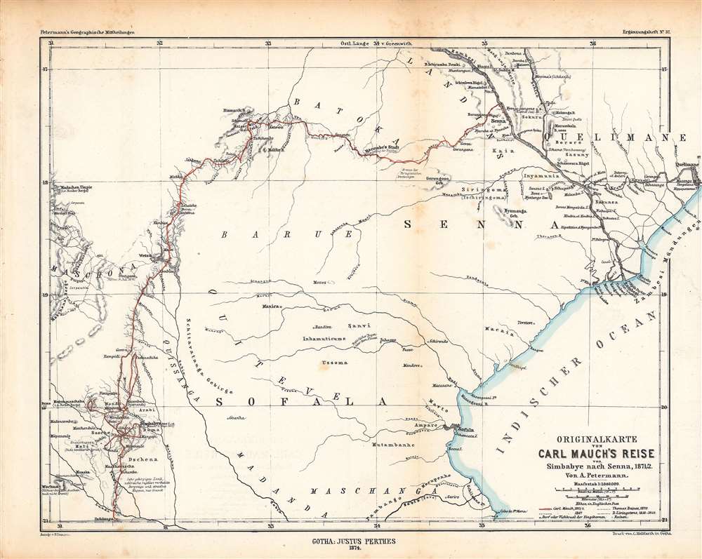
Originalkarte von Carl Mauch·s Reise von Simbabye nach Senna, 1871/72.
1874 (dated) 10.75 x 13.5 in (27.305 x 34.29 cm) 1 : 2000000
1874 (dated) 10.75 x 13.5 in (27.305 x 34.29 cm) 1 : 2000000
Description
This is an 1874 Augustus Petermann map of central Mozambique, tracing the journey of Carl (or Karl) Mauch, a German explorer. It depicts the area between the Zambezi and Save Rivers, where the Portuguese had long maintained a coastal presence with more tenuous control inland.
The map illustrates the routes of Mauch on two expeditions, made during 1867 and 1871 – 1872 respectively, along with the routes of the English explorers David Livingstone and Thomas Baines. Starting in the Transvaal, Mauch trekked northwards into what is now Zimbabwe and Mozambique, areas that often had been described in earlier Portuguese texts but had not been visited by Europeans in many years. Today, Mauch is mostly remembered for his description and interpretation of the stone ruins of the city Great Zimbabwe, which he believed to be the lost biblical city of Ophir, dismissing the idea that local peoples could have built the city.
While the Portuguese had long had a degree of control over the Mozambique coast, their presence inland was very limited. Some trading post-fortresses (noted as ruins) were established in earlier centuries and settlers moved inland, but by the early 19th century, these links were mostly a distant memory. In the early 19th century, the Portuguese state tried to induce greater settlement inland, with some success. But it was not sufficient to hold off the British. Once the 'Scramble for Africa' began and British mining interests rapidly moved into the interior of Africa, Portugal was helpless against the much more powerful British Empire.
A Closer Look
This map covers the territory from Quelimane in the north through the Sofala region, roughly the lands between the Zambezi and Save Rivers. The port city of Sofala (now Nova Sofala) attracted both Swahili and Portuguese traders seeking gold in the 12 - 16th centuries, but gradually lost its prominence, and in the 20th century was replaced by Beira, near the mouth of the Buzi (Busi) River. Height is given in English feet and Greenwich is used as the Prime Meridian, while scales are given in German miles and kilometers.The map illustrates the routes of Mauch on two expeditions, made during 1867 and 1871 – 1872 respectively, along with the routes of the English explorers David Livingstone and Thomas Baines. Starting in the Transvaal, Mauch trekked northwards into what is now Zimbabwe and Mozambique, areas that often had been described in earlier Portuguese texts but had not been visited by Europeans in many years. Today, Mauch is mostly remembered for his description and interpretation of the stone ruins of the city Great Zimbabwe, which he believed to be the lost biblical city of Ophir, dismissing the idea that local peoples could have built the city.
While the Portuguese had long had a degree of control over the Mozambique coast, their presence inland was very limited. Some trading post-fortresses (noted as ruins) were established in earlier centuries and settlers moved inland, but by the early 19th century, these links were mostly a distant memory. In the early 19th century, the Portuguese state tried to induce greater settlement inland, with some success. But it was not sufficient to hold off the British. Once the 'Scramble for Africa' began and British mining interests rapidly moved into the interior of Africa, Portugal was helpless against the much more powerful British Empire.
Publication History and Census
This map was made by Augustus Petermann, with text by Bruno Domann, and printed by Carl Hellfarth of the publisher Justus Perthes, based in Gotha. It was published as Supplement (Ergänzungsheft) No. 37 to the periodical Petermann's Geographische Mitteilungen. The full distribution of the map is difficult to determine due to inconsistent cataloging but is known to be held by the University of Chicago and the Bayerische Staatsbibliothek. It is scarce to the market.CartographerS
August Heinrich Petermann (1822 - 1878) was a German cartographer. Petermann attended the 'Geographische Kuntschule' (Geographica School of Art), which was started by Heinrich Berghaus with the support of Alexander von Humboldt, in Potsdam beginning in 1839. Students at the school were obliged to work on many of the school's contracts, including maps for several different atlases. Following his time in Potsdam, Petermann relocated to Edinburgh and London from 1845 to 1854, where he gained insight into the commercial aspects of the cartography business. In 1854, Petermann returned to Gotha, Germany and began working with the Perthes brothers publishers. While working with the Perthes brothers, Petermann founded the journal Petermanns Geographische Mitteilungen, published from 1855 until 2014, long one of the most prominent German-language geography journals. More by this mapmaker...
Carl Hellfarth (November 30, 1846 - July 12, 1918) was a German printer. Hellfarth was born in Gotha, Germany. He married Amalie Friederike Marie Möller (1850 - 1916) on June 16, 1873, and they had eight children. Learn More...
Johan Georg Justus Perthes (September 11, 1749 - May 2, 1816) was one of the most important German cartographic engravers of the 19th century. He was born in the Thuringian town of Rudolstadt, the son of a court physician. In 1778, he began working as a bookseller in Gotha. Perthes began his publishing empire shortly thereafter with the 1784 issue of the famed survey of European nobility known as the Almanac de Gotha. In the next year, 1785, he founded the cartographic firm of Justus Perthes Geographische Anstalt Gotha. His son Wilhelm Perthes (1793 - 1853) joined the firm in 1814. Wilhelm had prior publishing experience at the firm of Justus Perthes' nephew, Friedrich Christoph Perthes, who ran a publishing house in Hamburg. After Justus Perthes died in 1816, Wilhelm took charge and laid the groundwork for the firm to become a cartographic publishing titan. From 1817 to 1890. the Perthes firm issued thousands of maps and more than 20 different atlases. Along with the visionary editors Hermann Berghaus (1797 - 1884), Adolph Stieler (1775 - 1836), and Karl Spruner (1803 - 1892), the Perthes firm pioneered the Hand Atlas. When Wilhelm retired, management of the firm passed to his son, Bernhardt Wilhelm Perthes (1821 – 1857). Bernhardt brought on the cartographic geniuses August Heinrich Peterman (1822 - 1878) and Bruno Hassenstein (1839 - 1902). The firm was subsequently passed to a fourth generation in the form of Berhanrd Perthes (1858 – 1919), Bernhard Wilhelm's son. The firm continued in the family until 1953 when, being in East Germany, it was nationalized and run as a state-owned enterprise as VEB Hermann Haack Geographisch-Kartographische Anstalt Gotha. The Justus family, led by Joachim Justus Perthes and his son Wolf-Jürgen Perthes, relocated to Darmstadt where they founded the Justus Perthes Geographische Verlagsanstalt Darmstadt. Learn More...
Source
Ergänzungsheft No. 37, Petermann’s Geographische Mitteilungen, (Gotha: Petermann), 1874.
Condition
Good. Foxing along fold lines and in margins.
References
OCLC 65538676, 163821219.