Digital Image: 1939 Annand Pictorial Map of New York City and World's Fair
NYCPictorial-annand-1939_d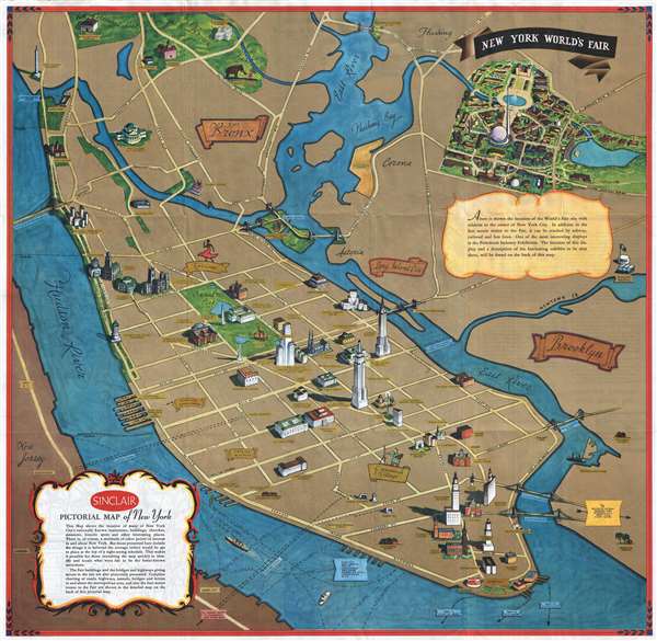

Title
Sinclair Pictorial Map of New York. / New York World's Fair.
1939 (dated) 26.5 x 27.5 in (67.31 x 69.85 cm)
1939 (dated) 26.5 x 27.5 in (67.31 x 69.85 cm)
Description
FOR THE ORIGINAL ANTIQUE MAP, WITH HISTORICAL ANALYSIS, CLICK HERE.
Digital Map Information
Geographicus maintains an archive of high-resolution rare map scans. We scan our maps at 300 DPI or higher, with newer images being 600 DPI, (either TIFF or JPEG, depending on when the scan was done) which is most cases in suitable for enlargement and printing.
Delivery
Once you purchase our digital scan service, you will receive a download link via email - usually within seconds. Digital orders are delivered as ZIP files, an industry standard file compression protocol that any computer should be able to unpack. Some of our files are very large, and can take some time to download. Most files are saved into your computer's 'Downloads' folder. All delivery is electronic. No physical product is shipped.
Credit and Scope of Use
You can use your digial image any way you want! Our digital images are unrestricted by copyright and can be used, modified, and published freely. The textual description that accompanies the original antique map is not included in the sale of digital images and remains protected by copyright. That said, we put significant care and effort into scanning and editing these maps, and we’d appreciate a credit when possible. Should you wish to credit us, please use the following credit line:
Courtesy of Geographicus Rare Antique Maps (https://www.geographicus.com).
How Large Can I Print?
In general, at 300 DPI, you should at least be able to double the size of the actual image, more so with our 600 DPI images. So, if the original was 10 x 12 inches, you can print at 20 x 24 inches, without quality loss. If your display requirements can accommodate some loss in image quality, you can make it even larger. That being said, no quality of scan will allow you to blow up at 10 x 12 inch map to wall size without significant quality loss. For more information, it is best consult a printer or reprographics specialist.
Refunds
If the high resolution image you ordered is unavailable, we will fully refund your purchase. Otherwise, digital images scans are a service, not a tangible product, and cannot be returned or refunded once the download link is used.
Cartographer S
George Annand (June 9, 1890 - September, 1980) was an American graphic artist and cartographer active in New York during the middle part of the 20th century. Annand was born in Croswell, Michigan, the sun of a Scottish immigrant doctor who immigrated to the United States via Canada. He received his early education at a one-room schoolhouse in Croswell before he and his parents relocated to Detroit. It was in Detroit that Annand was first introduced to the arts, enrolling in Art School. Later, as a young man, Annand move to New York City, where he continued his artistic studies at the Art Students League. In 1920 he married a childhood friend, Elizabeth Sinclair, who had been widowed during World War I. He adopted Elizabeth's two children and she and Annand shortly thereafter became pregnant with a third child. With a family to support and another 'bun in the oven' Annand turned to the booming New York advertising industry, taking work with the National Biscuit Company (NABISCO). He did well at NABISCO painting, as he liked to joke 'Fig Newtons in their native habitat.' He also took freelance work designing illustrated book covers. One of his first such jobs was illustrating a cover for C. E. Montague's Right off the Map. Naturally, given the nature of the work, the cover featured a map incorporating pictorial elements with aspects of baroque era cartography - Annand's first pictorial map. The Wall Street Crash of 1929 hit Annand's interests hard and he lost his job a Nabisco. Refusing WPA work for reasons of personal pride, Annand managed to get by on odd illustration contracts for various companies including publishers like Doubleday, Doran, and Charles Scribner, as well as pictorial map work for the Waldorf Astoria Hotel, General Foods, Sinclair Oil, and more. His cartographic work eventually drew the attention of the Chicago based map publishing giant Rand McNally, who commissioned him to produce two of their popular 'Romance Maps.' During and after World War II business began to pick up again and Annand produced a huge corpus of pictorial maps. His style combined decorative elements from 16th century Dutch decorative cartography, fine calligraphy, and more contemporary pictorial work. He wanted his maps are noteworthy for their clarity and the sense of space they convey. Annand was, according to Stephen Horsby in Picturing America: The Golden Age of Pictorial Maps, 'a cartographer's cartographer.' Annand continued to produce pictorial maps until forced to sop due to cataract surgery in 1970. He died 10 years later in 1980, at 90 years old. More by this mapmaker...
Rand, McNally and Co. (fl. 1856 - present) is an American publisher of maps, atlases and globes. The company was founded in 1856 when William H. Rand, a native of Quincy, Massachusetts, opened a print shop in Chicago. Rand hired the recent Irish immigrant Andrew McNally to assist in the shop giving him a wage of 9 USD per week. The duo landed several important contracts, including the Tribune's (later renamed the Chicago Tribune) printing operation. In 1872, Rand McNally produced its first map, a railroad guide, using a new cost effective printing technique known as wax process engraving. As Chicago developed as a railway hub, the Rand firm, now incorporated as Rand McNally, began producing a wide array of railroad maps and guides. Over time, the firm expanded into atlases, globes, educational material, and general literature. By embracing the wax engraving process, Rand McNally was able to dominate the map and atlas market, pushing more traditional American lithographic publishers like Colton, Johnson, and Mitchell out of business. Eventually Rand McNally opened an annex office in New York City headed by Caleb S. Hammond, whose name is today synonymous with maps and atlases, and who later started his own map company, C. S. Hammond & Co. Both firms remain in business. Learn More...
References
Rumsey 8242.003. OCLC 27440854.