Digital Image: 1870 Baur and Bromme Map of the World on Mercator Projection
NeuesteKartederErde-baur-1870_d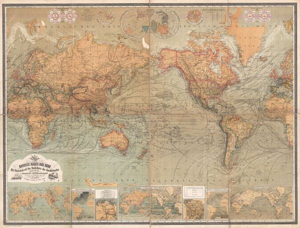

Title
Neueste Karte Der Erde Mit Rucksicht auf das Bedurfniss des Handelstandes sowie fur den Unterricht an Leher-Anstalten.
1870 (undated) 36 x 49 in (91.44 x 124.46 cm)
1870 (undated) 36 x 49 in (91.44 x 124.46 cm)
Description
FOR THE ORIGINAL ANTIQUE MAP, WITH HISTORICAL ANALYSIS, CLICK HERE.
Digital Map Information
Geographicus maintains an archive of high-resolution rare map scans. We scan our maps at 300 DPI or higher, with newer images being 600 DPI, (either TIFF or JPEG, depending on when the scan was done) which is most cases in suitable for enlargement and printing.
Delivery
Once you purchase our digital scan service, you will receive a download link via email - usually within seconds. Digital orders are delivered as ZIP files, an industry standard file compression protocol that any computer should be able to unpack. Some of our files are very large, and can take some time to download. Most files are saved into your computer's 'Downloads' folder. All delivery is electronic. No physical product is shipped.
Credit and Scope of Use
You can use your digial image any way you want! Our digital images are unrestricted by copyright and can be used, modified, and published freely. The textual description that accompanies the original antique map is not included in the sale of digital images and remains protected by copyright. That said, we put significant care and effort into scanning and editing these maps, and we’d appreciate a credit when possible. Should you wish to credit us, please use the following credit line:
Courtesy of Geographicus Rare Antique Maps (https://www.geographicus.com).
How Large Can I Print?
In general, at 300 DPI, you should at least be able to double the size of the actual image, more so with our 600 DPI images. So, if the original was 10 x 12 inches, you can print at 20 x 24 inches, without quality loss. If your display requirements can accommodate some loss in image quality, you can make it even larger. That being said, no quality of scan will allow you to blow up at 10 x 12 inch map to wall size without significant quality loss. For more information, it is best consult a printer or reprographics specialist.
Refunds
If the high resolution image you ordered is unavailable, we will fully refund your purchase. Otherwise, digital images scans are a service, not a tangible product, and cannot be returned or refunded once the download link is used.
Cartographer S
Carl Fredrich Baur (fl. c. 1850 - 1900) was a German map publisher active in Stuttgart during the mid to late 19th century. Baur was little known outside of Germany but nonetheless produced a number of important map most of which had a thematic or historic context. His most notable work is most likely the 1857 Atlas fur Handel und Industrie fur Kaufleute, Fabrikanten und Gewerbetreibende, one of the first industrial and commercial atlases of the 19th century. More by this mapmaker...
Traugott Bromme (1802 - December 4, 1865) was born in Anger Germany. In 1820 he relocated to the United States where he traveled extensively. As an immigrant to the United States he faced many of the challenges that modern immigrants face to this day, language issues, lack of jobs, and strange rules and customs. Nonetheless Bromme prospered, having many adventures including working as a surgeon on a Columbian war-schooner, cruising the West Indies, and being imprisoned in Haiti. In overcoming many of these issues Bromme composed what is most likely his most important work, a handbook for German emigrants, Hand-und Reisebuch fur Auswanderer nach den Vereinigten Staaten von Nord Amerika, Texas, Ober- und Under-Canada, Neu-Braunschweig, Neu Schottland, Santo Homans in Guatemala und de Mosquitokusten. Upon his return to Germany in the late 1840s he became a book and map publisher with a small but important corpus of work. Learn More...
References
U.C. Berkeley, Bancroft Library, G3200 1870 .B3.