Digital Image: 1885 Loggie Wall Map of New Brunswick, Canada
NewBrunswick-loggie-1885_d

Title
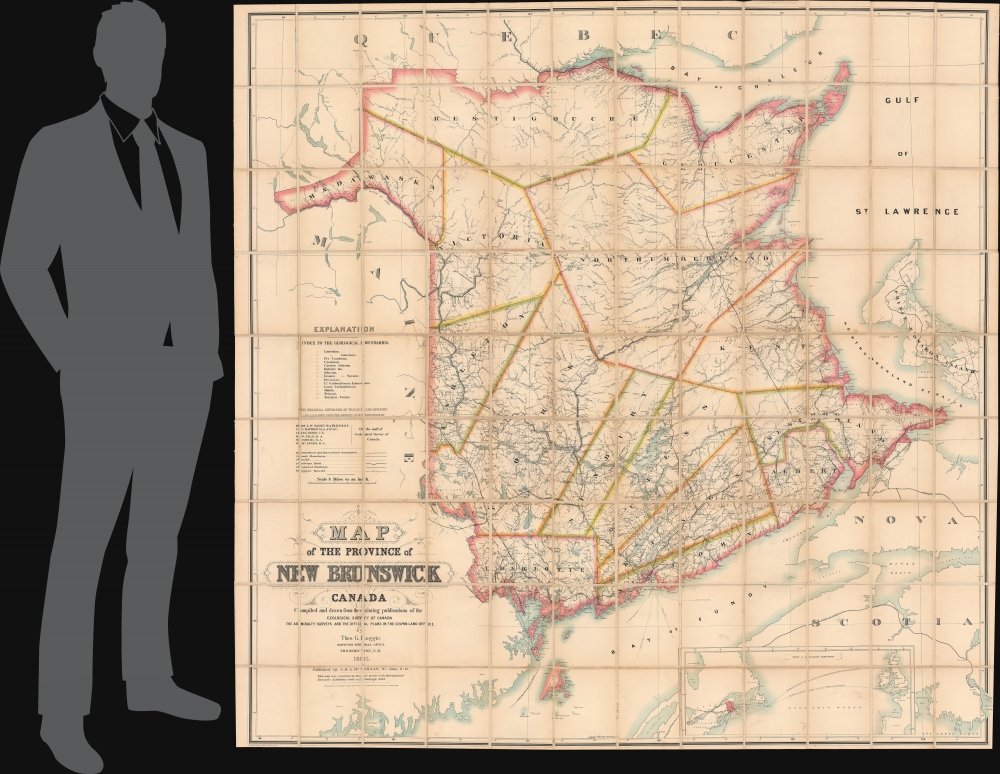
Map of the Province of New Brunswick, Canada.
1885 (dated) 71.75 x 72.25 in (182.245 x 183.515 cm) 1 : 253440
1885 (dated) 71.75 x 72.25 in (182.245 x 183.515 cm) 1 : 253440
Description
FOR THE ORIGINAL ANTIQUE MAP, WITH HISTORICAL ANALYSIS, CLICK HERE.
Digital Map Information
Geographicus maintains an archive of high-resolution rare map scans. We scan our maps at 300 DPI or higher, with newer images being 600 DPI, (either TIFF or JPEG, depending on when the scan was done) which is most cases in suitable for enlargement and printing.
Delivery
Once you purchase our digital scan service, you will receive a download link via email - usually within seconds. Digital orders are delivered as ZIP files, an industry standard file compression protocol that any computer should be able to unpack. Some of our files are very large, and can take some time to download. Most files are saved into your computer's 'Downloads' folder. All delivery is electronic. No physical product is shipped.
Credit and Scope of Use
You can use your digial image any way you want! Our digital images are unrestricted by copyright and can be used, modified, and published freely. The textual description that accompanies the original antique map is not included in the sale of digital images and remains protected by copyright. That said, we put significant care and effort into scanning and editing these maps, and we’d appreciate a credit when possible. Should you wish to credit us, please use the following credit line:
Courtesy of Geographicus Rare Antique Maps (https://www.geographicus.com).
How Large Can I Print?
In general, at 300 DPI, you should at least be able to double the size of the actual image, more so with our 600 DPI images. So, if the original was 10 x 12 inches, you can print at 20 x 24 inches, without quality loss. If your display requirements can accommodate some loss in image quality, you can make it even larger. That being said, no quality of scan will allow you to blow up at 10 x 12 inch map to wall size without significant quality loss. For more information, it is best consult a printer or reprographics specialist.
Refunds
If the high resolution image you ordered is unavailable, we will fully refund your purchase. Otherwise, digital images scans are a service, not a tangible product, and cannot be returned or refunded once the download link is used.
Cartographer S
Thomas George Johnston Loggie (November 12, 1854 - December 23, 1931) was a Canadian draftsman and sportsman. Loggie attended secondary school in Chatham, New Brunswick, and in 1871 started a job as a draftsman with the provincial Department of Lands and Mines. His 1885 'Map of the Province of New Brunswick, Canada' won a bronze medal at the 1884 International Forestry Exhibition in Edinburgh, Scotland. He became deputy surveyor general of New Brunswick in 1908. He received and honorary Master of Science in Forestry from the University of New Brunswick in 1914 and was awarded the Imperial Service Order in 1918. Loggie retired in 1925 after working as a civil servant for fifty-four years. Loggie represented New Brunswick in shooting competitions held at Wimbledon in England three times during the 1870s. He also helped found the Tabusintac Fishing Club, one of the first sporting clubs in Miramichi. More by this mapmaker...
John McMillan (fl. 1822 - c. 2000) was the founder of a publishing company that existed for over 120 years. McMillan immigrated from Belfast with his family, and he established a bookselling business in Saint John in 1822. He had three sons, James, Alexander, and David. In the late 1820s, James left for the United States where he worked as a journeyman printer and operated a bookstore in Indiana. James returned to Saint John in the mid-1840s to help his brothers Alexander and David and his ailing father with the family business, which had added a bindery and a printing office while James was in the U.S. James and Alexander renamed the business J and A McMillan in 1845. James had a son, John McMillan (November 9, 1833 - May 25, 1905), who was born while James was living in Indiana. After finishing school, John returned to the United States and joined the U.S. Navy and served until at least 1854. He returned to Saint John after leaving the Navy and worked in the family business, becoming a partner in May 1866. J and A McMillan became one of the most important publishers in the Maritimes by the 1850s, with some claiming that it was the most distinguished Maritimes publishing firm of the entire 19th century. The McMillan's building burned in the Great Saint John Fire of 1877 and was rebuilt in 1878. By the 1890s, McMillan's publishing business had so greatly diminished that it practically stopped publishing and focused solely on the printing business and selling general office supplies. After John's death in 1905, his son Alexander inherited the business. Alexander ran the business until his death in 1929, at which point the senior employees of J. and A. McMillan took control of the company. Learn More...
Alexander Keith Johnston (December 28, 1804 - July 9, 1871) was a Scottish cartographer and map publisher active in the middle portion of the 19th century. Johnson was born at Kirkhill, near Edinburgh, Scotland. He studied at the University of Edinburgh where he apprenticed as an engraver. Around 1826, in partnership with his brother William, he founded a cartographic printing and engraving firm with the imprint "W. and A. K. Johnston." Johnston made a name for himself in educational geography, publishing numerous maps for use in schools. His brother, William Johnston, eventually left the firm to pursue a career in politics, eventually becoming the Lord Provost of Edinburgh. Alexander's son, who would bear the same name, became a geographer and explorer, suffering an untimely death on the Royal Geographical Society's 1879 expedition to Lake Nyasa. Learn More...