This item has been sold, but you can get on the Waitlist to be notified if another example becomes available, or purchase a digital scan.
1885 Loggie Wall Map of New Brunswick, Canada
NewBrunswick-loggie-1885$2,250.00


Title
Map of the Province of New Brunswick, Canada.
1885 (dated) 71.75 x 72.25 in (182.245 x 183.515 cm) 1 : 253440
1885 (dated) 71.75 x 72.25 in (182.245 x 183.515 cm) 1 : 253440
Description
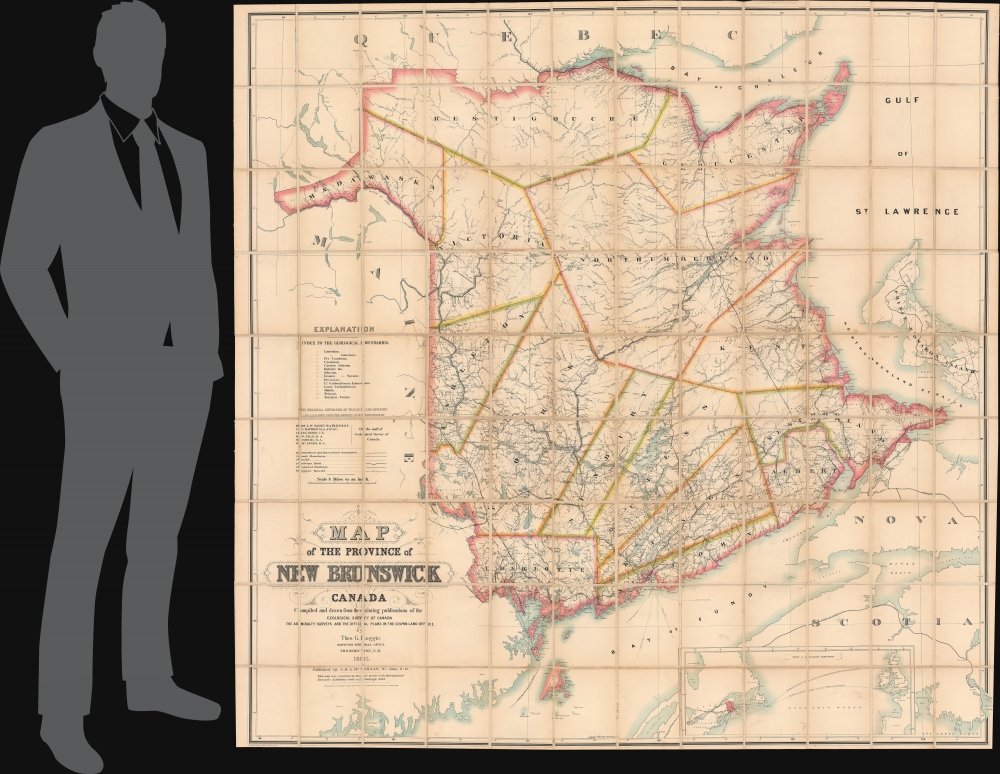
A monumental piece, this is the 1885 Thomas Loggie wall map of New Brunswick, Canada. Awarded the bronze medal at the First International Forestry Exhibition (a world's fair held in Edinburgh in 1884), detail abounds with cities, towns, and villages labeled throughout the province. Several railways crisscross New Brunswick, including the Northern and Western Railway, the New Brunswick Railway, the Caraquette Railway, and the Intercolonial Railway. Major roads appear as well. Rivers, lakes, and other physical features are illustrated. Pale blue dotted and dashed lines labeled alphabetically delineate geological boundaries and correspond with an index along the left side above the title.
Arthurette Colonization Road
Arthurette Colonization Road is labeled to the right of the letter 'A' in Maine. We have been unable to trace the exact history of this colonization road. Colonization roads were created in the 1840s and 1850s in Canada and led settlers to areas for settlement, resembling a modern-day highway network. To this day, streets named 'Colonization Road' can be found in towns in Canada, a painful reminder for First Nation peoples.Publication History and Census
This map was created by Thomas Loggie, engraved by W. and A. K. Johnston, and published by J and A McMillan in 1885. Six examples are cataloged in OCLC and are part of the collections at the Library of Congress, Queen's University, Concordia University, the Bibliotheque et Archives nationales du Québec, the U.K. Public Record Office, and the Staatsbibliothek zu Berlin.CartographerS
Thomas George Johnston Loggie (November 12, 1854 - December 23, 1931) was a Canadian draftsman and sportsman. Loggie attended secondary school in Chatham, New Brunswick, and in 1871 started a job as a draftsman with the provincial Department of Lands and Mines. His 1885 'Map of the Province of New Brunswick, Canada' won a bronze medal at the 1884 International Forestry Exhibition in Edinburgh, Scotland. He became deputy surveyor general of New Brunswick in 1908. He received and honorary Master of Science in Forestry from the University of New Brunswick in 1914 and was awarded the Imperial Service Order in 1918. Loggie retired in 1925 after working as a civil servant for fifty-four years. Loggie represented New Brunswick in shooting competitions held at Wimbledon in England three times during the 1870s. He also helped found the Tabusintac Fishing Club, one of the first sporting clubs in Miramichi. More by this mapmaker...
John McMillan (fl. 1822 - c. 2000) was the founder of a publishing company that existed for over 120 years. McMillan immigrated from Belfast with his family, and he established a bookselling business in Saint John in 1822. He had three sons, James, Alexander, and David. In the late 1820s, James left for the United States where he worked as a journeyman printer and operated a bookstore in Indiana. James returned to Saint John in the mid-1840s to help his brothers Alexander and David and his ailing father with the family business, which had added a bindery and a printing office while James was in the U.S. James and Alexander renamed the business J and A McMillan in 1845. James had a son, John McMillan (November 9, 1833 - May 25, 1905), who was born while James was living in Indiana. After finishing school, John returned to the United States and joined the U.S. Navy and served until at least 1854. He returned to Saint John after leaving the Navy and worked in the family business, becoming a partner in May 1866. J and A McMillan became one of the most important publishers in the Maritimes by the 1850s, with some claiming that it was the most distinguished Maritimes publishing firm of the entire 19th century. The McMillan's building burned in the Great Saint John Fire of 1877 and was rebuilt in 1878. By the 1890s, McMillan's publishing business had so greatly diminished that it practically stopped publishing and focused solely on the printing business and selling general office supplies. After John's death in 1905, his son Alexander inherited the business. Alexander ran the business until his death in 1929, at which point the senior employees of J. and A. McMillan took control of the company. Learn More...
Alexander Keith Johnston (December 28, 1804 - July 9, 1871) was a Scottish cartographer and map publisher active in the middle portion of the 19th century. Johnson was born at Kirkhill, near Edinburgh, Scotland. He studied at the University of Edinburgh where he apprenticed as an engraver. Around 1826, in partnership with his brother William, he founded a cartographic printing and engraving firm with the imprint "W. and A. K. Johnston." Johnston made a name for himself in educational geography, publishing numerous maps for use in schools. His brother, William Johnston, eventually left the firm to pursue a career in politics, eventually becoming the Lord Provost of Edinburgh. Alexander's son, who would bear the same name, became a geographer and explorer, suffering an untimely death on the Royal Geographical Society's 1879 expedition to Lake Nyasa. Learn More...
Condition
Very good. Dissected and mounted on linen in 108 panels.