1774 Cook Benard/ Hawkesworth Chart of New Guinea, New Britain and New Ireland
NewGuineaNewBritain-benard-1774$350.00
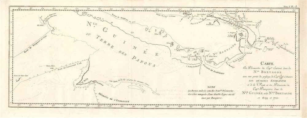

Title
Carte des découvertes du Cap.ne Carteret dans la Nle. Bretagne avec une partie de du passage du Cap.ne Cook à travers les Détroits Endeavour et de la route et des découvertes du Cap.ne Dampierre dans la Nle. Guinée et la Nle. Bretagne en 1699 et 1700.
1774 (undated) 8.5 x 24 in (21.59 x 60.96 cm) 1 : 4777813
1774 (undated) 8.5 x 24 in (21.59 x 60.96 cm) 1 : 4777813
Description
This is a 1774 nautical map of the discoveries of Captain Carteret Captain James Cook in the East Indies, specifically the waters around Papua New Guinea. The earlier track of Captain Dampier (1699 and 1700) is also shown.
Dampier
The track of William Dampier comes from that British captain, explorer and pirate's journey to Australia aboard HMS Roebuck. The chart shows his 1699-1700 route following his visit to Western Australia - arriving at the western tip of New Guinea, then tracing the island's northern shore heading east. Dampier's track then follows the southern coasts of New Britain and New Ireland - which he also named.Carteret
Coming from the east - following a miserable, scurvy-ridden Pacific crossing - Carteret aboard HMS Swallow would cross Dampier's track, charting the Strait of St. George between New Britain and New Ireland (which Dampier had named, but not explored.) He was the first European to chart the archipelago in the Strait.Cook
The chart includes Captain Cook's track, coasting Dolok Island off southwestern New Guinea (here named Cap Walsh) before continuing west across the Arafura sea. The body of water south of New Guinea is named 'Détroits de l'Endeavour' despite that name applying now to the passage between mainland Australia and Prince of Wales Island.Publication History and Census
This map was engraved by Robert Bénard for the 1774 French edition of James Hawkesworth's Relation des voyages entrepris par ordre de Sa Majeste britannique actuellement regnante, an account of Cook's voyages. The separate engraving appears to be neglected by institutional collections, appearing only in the National Library of Australia. The full text, however, is well represented in institutional collections.CartographerS
Robert Bénard (1734 - c. 1785) was a French engraver. Born in Paris, Bénard is best known for supplying a significant number of plates (at least 1,800) for the Encyclopédie published by Diderot and Alembert. He also is remembered for his work with the Académie des Sciences, most notably the Descriptions des Arts et Métiers More by this mapmaker...
John Hawkesworth (c. 1715 - November 16, 1773) was an English born writer and editor born London. Hawkesworth, who is said to have been self educated, succeeded Samuel Johnson as the parliamentary debate compiler for "Gentleman's Magazine". He was a deeply religious and moral map who brilliant defense of morality earned him an LL. D degree from the Archbishop of Canterbury. Hawkesworth went on to publish a series of scholarly books and essays including a 12 volume edition of Jonathan Swift's work. In 1772 Hawkesworth was commissioned by the Admiralty to compile and edit James Cook's journals. The resultant work An Account of the Voyages undertaken ... for making discoveries in the Southern Hemisphere was one of the first ethnographic account of the South Seas and was widely published in England and abroad. Though highly influential, Hawkesworth's work received heavy criticism from scholars who claim that he liberally altered much of the text in the name of morality. Learn More...
Captain James Cook (7 November 1728 - 14 February 1779) is a seminal figure in the history of cartography for which we can offer only a cursory treatment here. Cook began sailing as a teenager in the British Merchant Navy before joining the Royal Navy in 1755. He was posted in America for a time where he worked Samuel Holland, William Bligh, and others in the mapping of the St. Lawrence River and Newfoundland. In 1766 Cook was commissioned to explore the Pacific and given a Captaincy with command of the Endeavour. What followed were three historic voyages of discovery, the highlights of which include the first European contact with eastern Australia, the discovery of the Hawaiian Islands (among many other Polynesian groups), the first circumnavigation of New Zealand, some of the first sightings of Antarctica, the first accurate mapping of the Pacific Northwest, and ultimately his own untimely death at the hands of angry Hawaiians in 1779. The influence of Cook work on the mapping and exploration of the Pacific cannot be understated. Learn More...
Source
Hawkesworth, John Relation des voyages entrepris par ordre de Sa Majeste britannique actuellement regnante. (Paris : Chez Saillant et Nyon) 1774
Condition
Very good condition. Some very faint offsetting, else an excellent example.
References
OCLC 499969976.