1860 Cruchley Pocket Map of London, England
NewPlanofLondon-cruchley-1860$550.00

Title
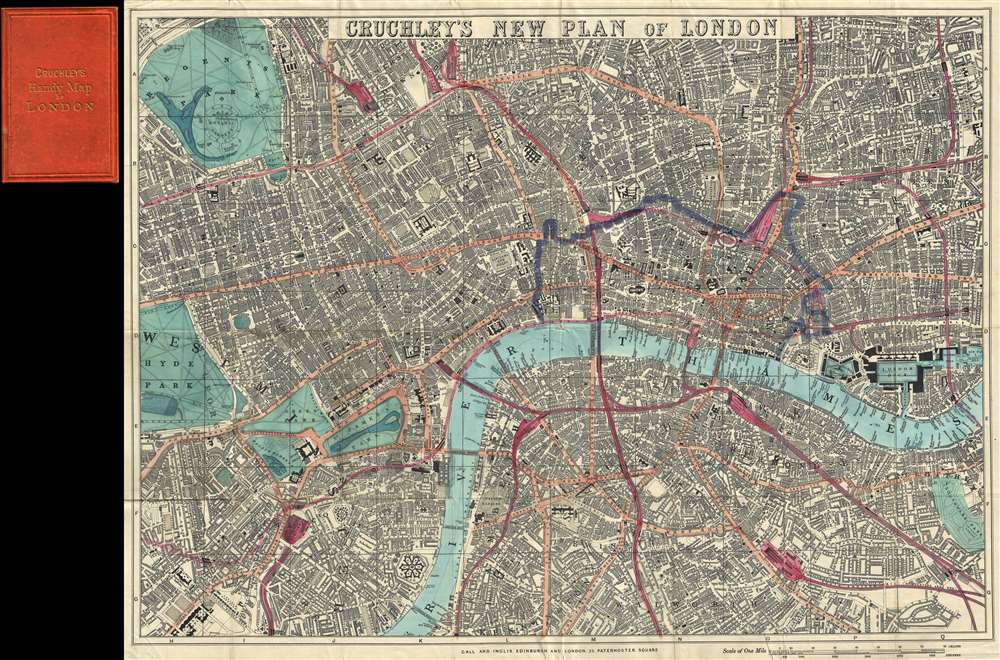
Cruchley's New Plan of London.
1860 (undated) 18.5 x 25.5 in (46.99 x 64.77 cm) 1 : 12672
1860 (undated) 18.5 x 25.5 in (46.99 x 64.77 cm) 1 : 12672
Description
A first-edition example of George Frederick Cruchley's 1860 pocket map of London, England. The map captures the city at the height of the city-wide 19th-century urbanization that coincided with the Industrial Revolution.
A Closer Look
Centered on Blackfriars Bridge, the map covers from Regent's Park to Chelsea Hospital and from Hyde Park to Southwark Park. Streets, bridges, wharves, docks, parks, the imprints of important buildings, and railway stations are identified throughout. The map gives particular attention to the railroads, highlighted in red, that were being developed throughout London at the time. A purple border outlines the City of London.Historical Context: A City of Extremes
London in 1860 was a rapidly growing metropolis at the heart of the British Empire, undergoing an epoch-defining transformation due to the Industrial Revolution. At the time, London's population reached over three million, making it the largest city in the world, with a skyline increasingly defined by new industrial structures and railways. Extensive urbanization of the suburbs and landmark projects like the construction of the London Underground (which began in 1863) aimed to modernize the city - forcing map makers to constantly update maps to keep up with the changes. Alongside this prosperity, there was a growing undercurrent of severe social problems: overcrowded slums, poor sanitation, class inequality, and widespread poverty.Publication History and Census
This map was printed by Gall and Inglis of 25 Paternoster Square for George Frederick Cruchley.CartographerS
George Frederick Cruchley (April 23, 1797 - June 16, 1880) was a London based book and map seller active in the middle part of the 19th century. Cruchley began his cartographic career as an apprentice at the venerable Aaroon Arrowsmith firm. Many of Cruchley's earliest maps bear the words 'From Arrowsmith's' on the imprint. In 1844, Cruchley acquired the massive stock of the important early 19th century firm of John Cary. Cruchley published his own maps as well as reissues of Cary's stock well into the 1870s. He is best known for his detailed plans of London, which in recent years have become increasingly scarce and desirable. Cruchley was based in London on 38 Ludgate Street until 1834 when he moved his offices to 81 Fleet Street. Shortly before his death in 1880 Cruchely auctioned (Hodgson's Auctions, Jan 16, 1877) his entire stock. Many of his map plates were thusly acquired by 'Gall and Inglis' who continued the Cruchley tradition well into the early 20th century. Cruchley's son, also George Frederick (1837 - 1882), continued to work as a book and map seller until his death. More by this mapmaker...
Gall and Inglis' (1810 - 1960) were Edinburgh based publishers. The firm was founded c. 1810 by James Gall. Gall went through a series of partnerships with other publishers including Turnbull, Hay, and finally Robert Inglis. Their publishing work consisted of novels, textbooks, guide, and essays as well as maps. They were also ordinance survey publishers. Learn More...
Condition
Very good. Folds into original binder.
References
Hyde, R., Printed Maps of Victorian London 1851 - 1900, #66.1.