Digital Image: 1874 Canal Commissioners Map of New York State Canals
NewYorkCanals-commissioners-1874_d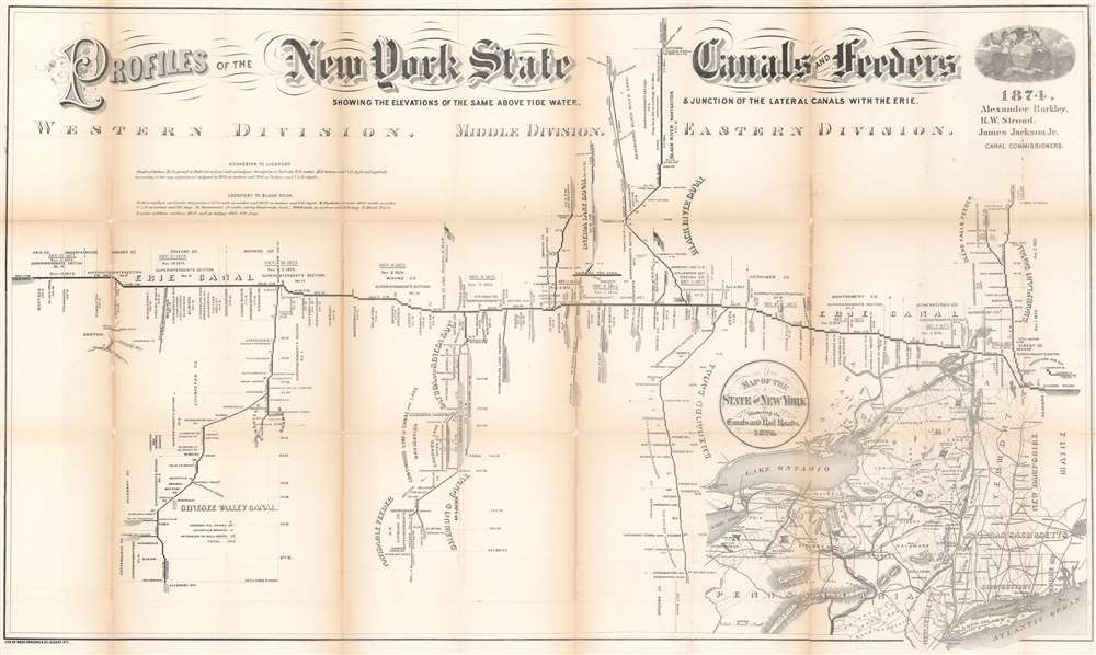

Title
Profiles of the New York State Canals and Feeders Showing the Elevations of the Same Above Tide Water and Junction of the Lateral Canals with the Erie.
1874 (dated) 24.5 x 41 in (62.23 x 104.14 cm) 1 : 633600
1874 (dated) 24.5 x 41 in (62.23 x 104.14 cm) 1 : 633600
Description
FOR THE ORIGINAL ANTIQUE MAP, WITH HISTORICAL ANALYSIS, CLICK HERE.
Digital Map Information
Geographicus maintains an archive of high-resolution rare map scans. We scan our maps at 300 DPI or higher, with newer images being 600 DPI, (either TIFF or JPEG, depending on when the scan was done) which is most cases in suitable for enlargement and printing.
Delivery
Once you purchase our digital scan service, you will receive a download link via email - usually within seconds. Digital orders are delivered as ZIP files, an industry standard file compression protocol that any computer should be able to unpack. Some of our files are very large, and can take some time to download. Most files are saved into your computer's 'Downloads' folder. All delivery is electronic. No physical product is shipped.
Credit and Scope of Use
You can use your digial image any way you want! Our digital images are unrestricted by copyright and can be used, modified, and published freely. The textual description that accompanies the original antique map is not included in the sale of digital images and remains protected by copyright. That said, we put significant care and effort into scanning and editing these maps, and we’d appreciate a credit when possible. Should you wish to credit us, please use the following credit line:
Courtesy of Geographicus Rare Antique Maps (https://www.geographicus.com).
How Large Can I Print?
In general, at 300 DPI, you should at least be able to double the size of the actual image, more so with our 600 DPI images. So, if the original was 10 x 12 inches, you can print at 20 x 24 inches, without quality loss. If your display requirements can accommodate some loss in image quality, you can make it even larger. That being said, no quality of scan will allow you to blow up at 10 x 12 inch map to wall size without significant quality loss. For more information, it is best consult a printer or reprographics specialist.
Refunds
If the high resolution image you ordered is unavailable, we will fully refund your purchase. Otherwise, digital images scans are a service, not a tangible product, and cannot be returned or refunded once the download link is used.
Cartographer
Weed, Parsons and Company (July 25, 1843 - July, 1892) was a New York based printing house based in Albany, active in the second half of the 19th century. The firm was founded by J. B. Weed (???? - June 18, 1851) and John D. Parsons. Weed, the son of Thurlow Weed, previously worked for the Evening Journal. Parsons was a compositor in the printing offices of Packard and Van Benthuysen. Shortly after their startup, the firm received financing from Visscher Ten Eyck, one of the owners of the Evening Journal to dramatically expand their printing operation. Leveraging Parsons' contacts with the state, the firm began receiving lucrative government printing contracts out of Albany. By 1868 they were one of the largest printing concerns in the United States. Their offices were gutted by a major fire on April 7, 1871. The owners rebuilt with new more modern equipment and continued to operate, with heirs taking over the shares of the original owners. They remained in operation until the firm went into receivership in July of 1892. More by this mapmaker...