This item has been sold, but you can get on the Waitlist to be notified if another example becomes available, or purchase a digital scan.
1940 Geographia City Map or Plan of New York City (Upper Manhattan and Bronx)
NewYorkManhattanBronx-gross-1940$75.00

Title
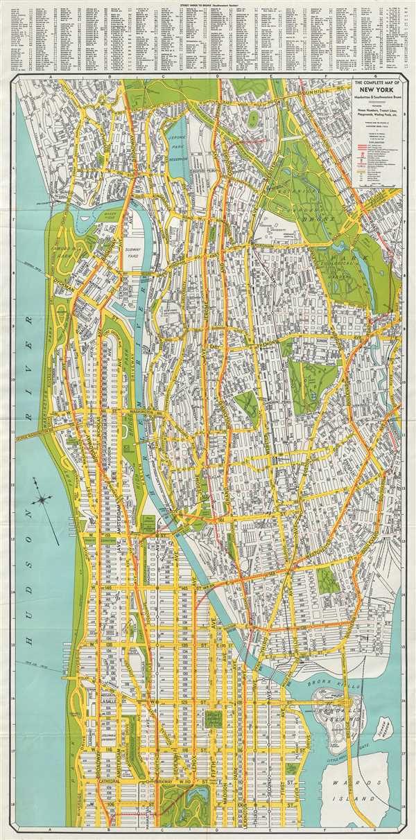
The Complete Map of New York Manhattan and Southwestern Bronx.
1940 (undated) 36 x 18 in (91.44 x 45.72 cm) 1 : 22000
1940 (undated) 36 x 18 in (91.44 x 45.72 cm) 1 : 22000
Description
This is an excellent map of New York City by Alexander Gross dating to c.1940. The map covers the northern portions of the borough of Manhattan from 102nd Street to Inwood. The southwest portion of Bronx is also covered southward from Van Cortlandt Park. Randall’s Island, Ward’s Island and Sunken Meadow are noted as separate land masses.
In 1855, the city of New York would acquire the two islands and the Sunken Meadow marsh which would eventually become one single Island. The map offers extraordinary detail throughout, noting the IRT (Interborough Rapid Transit Company) subway lines, the BMT (Brooklyn-Manhattan Transit Corporation) subway lines, elevated lines, Independent subway lines, ferry lines, bus lines and stations. Parks, streets and important buildings are also identified.
At the time this map was published, New York had earned the reputation of being the most urbanized city in the world. As the world's first megalopolis, New York witnessed large-scale development in its infrastructure even during the Depression era. In fact, some of the New York's tallest skyscrapers and art deco buildings were built during this period.
This map was published under the direction of Alexander Gross and published by the Geographia Map Co.
Cartographer
Geographia, Ltd. (1911 - 1985) was a London-based cartographic publishing firm. The company was founded by Alexander Gross (1879 - 1958), a Hungarian immigrant to the United Kingdom. Geographia Ltd. is best known for its folding pocket maps and globes. Many of his maps were drawn by a mysterious 'Mr. Fountain', of whom we have been able to discover little. Gross ran into financial problems around 1940, likely associated with World War II, and relocated to offices in New York at 11 John Street. There, he issued a large corpus of U.S.-focused maps and city plans. By the 1940s, the branch in the United States had been renamed the Geographia Map Company and experienced rapid growth. By the 1950s, Geographia had published maps of dozens of cities across the United States. In 1987, the British branch was bought out by Harper Collins and continues to produce maps under the Collins Bartholomew imprint. Rand McNally bought the New York-based Geographia Map Company in the late 1980s. However, its original owners repurchased the Geographia Map Company a few years later and still operate the company in Hackensack, New Jersey. Gross's daughter, Phyllis Isobella Gross / Pearsall (1906 - 1996), founded the Geographers' A-Z Map Company in London, the largest independent map publisher in the United Kingdom. In the UK, their offices were originally at 33 Strand, where they published as 'Geographia Designing and Publishing Company Ltd.'. Later, by 1933, they had relocated to 55 Fleet Street, where they remained until at least 1937. By 1942, they relocated to 167 Fleet Street, followed by 114 Fleet Street by 1964. It is of note that many of the Geographia Ltd. maps feature a peculiar dating system wherein the letters in the world CUMBERLAND correspond to the numbers 1234567890, such that a date is rendered by substitution, so A.MU would break out like this A = 8, M = 3, U = 2, so 8.32 or, August 1932. Or, MM.YY e.g. E.MC = 5.31 = May 1931. More by this mapmaker...
Condition
Very good. Minor wear along original fold lines.