Digital Image: 1950 Garbush Map of Manhattan, New York City
NewYorkNorman-garbush-1950_d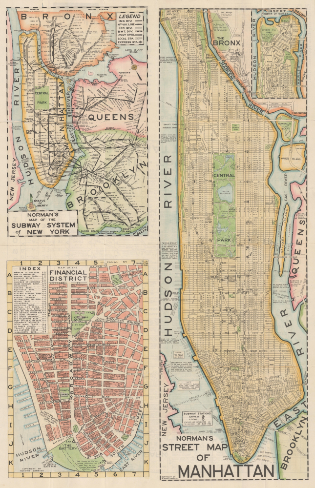


Title
Norman's Simplified Maps of New York City / Norman's Street Map of Manhattan / Norman's Map of the Subway System of New York / Map of the Financial District / Mid-town Manhattan.
1950 (undated) 33.5 x 21.75 in (85.09 x 55.245 cm)
1950 (undated) 33.5 x 21.75 in (85.09 x 55.245 cm)
Description
FOR THE ORIGINAL ANTIQUE MAP, WITH HISTORICAL ANALYSIS, CLICK HERE.
Digital Map Information
Geographicus maintains an archive of high-resolution rare map scans. We scan our maps at 300 DPI or higher, with newer images being 600 DPI, (either TIFF or JPEG, depending on when the scan was done) which is most cases in suitable for enlargement and printing.
Delivery
Once you purchase our digital scan service, you will receive a download link via email - usually within seconds. Digital orders are delivered as ZIP files, an industry standard file compression protocol that any computer should be able to unpack. Some of our files are very large, and can take some time to download. Most files are saved into your computer's 'Downloads' folder. All delivery is electronic. No physical product is shipped.
Credit and Scope of Use
You can use your digial image any way you want! Our digital images are unrestricted by copyright and can be used, modified, and published freely. The textual description that accompanies the original antique map is not included in the sale of digital images and remains protected by copyright. That said, we put significant care and effort into scanning and editing these maps, and we’d appreciate a credit when possible. Should you wish to credit us, please use the following credit line:
Courtesy of Geographicus Rare Antique Maps (https://www.geographicus.com).
How Large Can I Print?
In general, at 300 DPI, you should at least be able to double the size of the actual image, more so with our 600 DPI images. So, if the original was 10 x 12 inches, you can print at 20 x 24 inches, without quality loss. If your display requirements can accommodate some loss in image quality, you can make it even larger. That being said, no quality of scan will allow you to blow up at 10 x 12 inch map to wall size without significant quality loss. For more information, it is best consult a printer or reprographics specialist.
Refunds
If the high resolution image you ordered is unavailable, we will fully refund your purchase. Otherwise, digital images scans are a service, not a tangible product, and cannot be returned or refunded once the download link is used.
Cartographer
Norman Lawrence Garbush (March 7, 1897 - May 10, 1972) was a mostly Minnesota-based cartographer and map publisher. The details of his life are difficult to determine and he remarkably seems to have disappeared from census and other records for several decades. Garbush was raised in Stillwater, Minnesota (near Minneapolis) and received training as a civil engineer and surveyor, producing at least one map of his native region in the 1920s (OCLC 882500843). At some point in the mid-late 1940s, he looks to have relocated to New York City, very likely for military service in the Second World War. Around this time, he began publishing his best known work, 'Norman's Simplified Maps of New York City,' which was issued in several editions (all undated) from roughly the late 1940s to the 1960s. However, Garbush appears to have only lived in the city for a short time, returning to Minnesota by the early 1950s. From there, he continued to publish his New York City maps with local partners, as well as branching out to issue similar maps of Miami, South Florida writ large, Denver, Dallas, and Los Angeles (being an outsider to these places and not knowing colloquial placenames, some of these maps failed to impress locals despite their comprehensiveness). Aside from his independent map publishing, Garbush looks to have worked at the Minnesota Department of Highways in the latter part of his career. More by this mapmaker...
References
OCLC 977357550, 56697551.