This item has been sold, but you can get on the Waitlist to be notified if another example becomes available, or purchase a digital scan.
1909 Hockin Manuscript Map of New Zealand
NewZealand-hockin-1909$1,975.00

Title
New Zealand.
1909 (dated) 16 x 12 in (40.64 x 30.48 cm) 1 : 4170000
1909 (dated) 16 x 12 in (40.64 x 30.48 cm) 1 : 4170000
Description
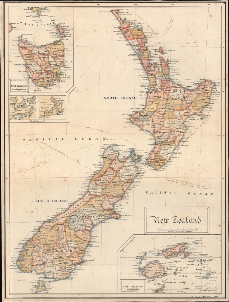
A meticulous manuscript map of New Zealand drawn in 1909 by William Richard Colling Hockin. It was composed soon after New Zealand gained Dominion status within the British Empire, formalizing its independence, and this may have been the occasion that brought New Zealand to the attention of Hockin, then studying in Cornwall to be an electrical engineer. Since we see no other cartographic output from this artist, we must assume this work to be a unique project of leisure and enjoyment; a thoughtful young man's rumination on one of the Empire's newest and most exotic dominions.
Hockin has added a new feature: the shipping routes to Sydney, London, Honolulu, San Francisco, Buenos Aires, and other points, noting the distances between points: 'London to Wellington 16084'.
Work Of Cartographic Art
Perhaps due to Hockin's maturity (he was 21 or 22 in 1909), his work is of a remarkably high quality for this type of map. It is a painstaking copy of the New Zealand map produced by John Bartholomew (from either the 1898 or 1902 edition of The Citizen's Atlas of the World). What it lacks in cartographic originality, Hockin's map has in beauty of execution. Terrain is indicated with neat hachure, and overall, Hockin's lines are superbly precise. His delineations of rivers are particularly well done, very fine upstream, while gracefully thickening downstream. His lettering, too, is neat and attractive; his dedication to orienting his text to the top of the map makes this more legible than the original. While he has adhered scrupulously to the layout of his source's 1898 map, he has chosen to place his map's title in a simple cartouche above the scales, rather than above the top border (perhaps both an aesthetic decision and a practical one, if it was his intention to fill the cardstock with his composition). The map's outline and wash color are more muted and delicate than the somewhat garish Bartholomew, and Hockin's watercolors are light enough not to interfere with the map's legibility: an important trick to have learned.A Closer Look
Hockin's map preserves all of the detail of its source. The North and South Islands of New Zealand are displayed clearly, with regions and districts labeled, outlined, and color-coded. Waterways, mountains, coastal features, and islands are illustrated throughout. The inset maps of Tasmania, Auckland and environs, Dunedin and Otago Harbour, and the Fiji Islands are also drawn from the Bartholomew, and the style of the borders are consistent with that source.Hockin has added a new feature: the shipping routes to Sydney, London, Honolulu, San Francisco, Buenos Aires, and other points, noting the distances between points: 'London to Wellington 16084'.
Publication History and Census
This manuscript map was drawn by William Richard Colling Hockin and is dated 1909. It is a close copy of the Bartholomew map appearing in The Citizen's Atlas of the World. While such student works do appear, we have seen no comparable work focusing on New Zealand.CartographerS
William Richard Colling Hockin (December 30, 1887 - August 31, 1966) Was an English electrician and manager, who served in the Navy during the Great War. Little is known of his youth, but he appears to have been in training as an electrical engineer associated with the Carn Brea coal mines in and around 1908. He married in 1911; his name appeared in the January 1917 Navy List, having been appointed to the Navy for 'temporary service during the War.' He survived the war and raised a family. We see him in Somerset in 1939, employed as a Managing Director of Road Repair. According to newspaper records, he also was an avid tennis and badminton player. As a cartographer, his only known work is a 1909 manuscript map of New Zealand - produced in and around his time as a student. More by this mapmaker...
The Bartholomew Family (fl. c. 1810 - 1920) is clan of map publishers active in London through the 19th century. They represent one of the great names in British cartography. The cartographic story of the Bartholomew family begins with George Bartholomew (January, 8 1784 - October 23, 1871, active from 1797), an engraver in the employ of the Daniel Lizars firm of Edinburgh. George was the first of six generations in the Bartholomew map-making dynasty. It was his son, John Bartholomew Sr. (1805 - April 9, 1861) who ultimately founded John Bartholomew and Sons in 1828. The John Bartholomew firm produced thousands of maps and rose to become one of the largest and most prolific cartography firms in Scotland. John Sr. was succeeded by his son, also John Bartholomew Jr. (1831-93). John George Bartholomew (1860-1920), son of John Bartholomew (1831-93) took control of the firm at its height. John George was a charter member of the Royal Scottish Geographical Society and supported the creation of a National Institute of Geography - a good idea that never took off. John George is also reliably attributed to be the first to bring the term "Antarctica" into popular usage as a denominator for the Southern Continent. In recognition of his work, John George was awarded a warrant from the king and often used the title "Cartographer to the King" on his imprint. Among his friends and admirers he was referred to as the "Prince of Cartography". John (Ian) Bartholomew (1890 - 1962) continued the family business and oversaw publication of the Times Survey Atlas of the World in 1922 and the Mid Century Edition of the Time Atlas of the World from 1955 - 1960. John Christoper Bartholomew (1923 - 2008) continued the family business into a fifth generation and was fascinated by the natural sciences. He spearheaded the publication of many of the most detailed and popular maps of the last century. His brother Robert, a trained printer, became production director. Another brother, Peter, an accountant, started as a managing director and eventually became executive chairman. The John Bartholomew firm has been part of the HarperCollins family of publishers since 1989. The vast archive of maps and atlases produced by the Bartholomew family has since been transferred to the National Library of Scotland where it is currently in the cataloguing process. Learn More...
Condition
Manuscript map, pen, ink and watercolor on heavy card stock. Margins narrow but border complete. Minor foxing.