Digital Image: 1923 Stigand Map of North-West District or Ngamiland, Botswana - Okavango Delta
NgamilandGhanzi-stigand-1923_d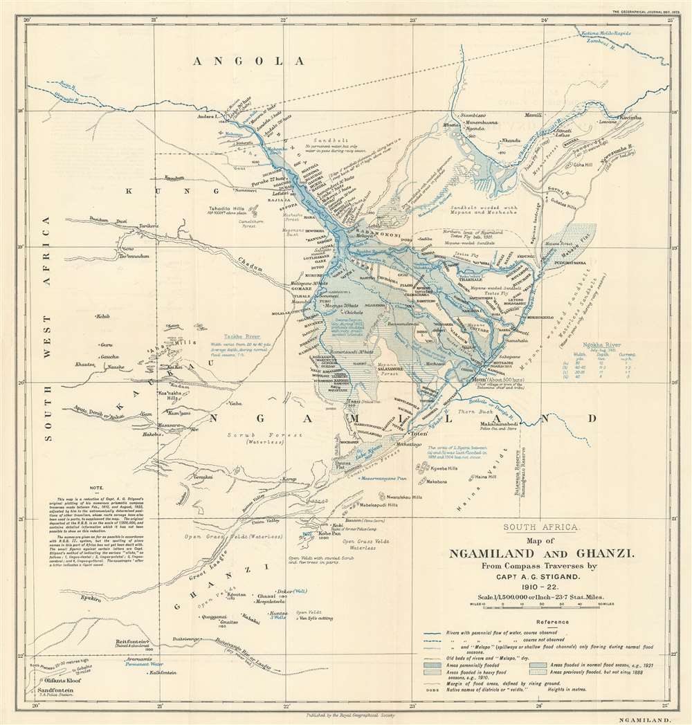

Title
South Africa. Map of Ngamiland and Ghanzi. From Compass Traverses by Capt. A.G. Stigand. 1910 - 1922.
1923 (dated) 15.5 x 14.75 in (39.37 x 37.465 cm) 1 : 1500000
1923 (dated) 15.5 x 14.75 in (39.37 x 37.465 cm) 1 : 1500000
Description
FOR THE ORIGINAL ANTIQUE MAP, WITH HISTORICAL ANALYSIS, CLICK HERE.
Digital Map Information
Geographicus maintains an archive of high-resolution rare map scans. We scan our maps at 300 DPI or higher, with newer images being 600 DPI, (either TIFF or JPEG, depending on when the scan was done) which is most cases in suitable for enlargement and printing.
Delivery
Once you purchase our digital scan service, you will receive a download link via email - usually within seconds. Digital orders are delivered as ZIP files, an industry standard file compression protocol that any computer should be able to unpack. Some of our files are very large, and can take some time to download. Most files are saved into your computer's 'Downloads' folder. All delivery is electronic. No physical product is shipped.
Credit and Scope of Use
You can use your digial image any way you want! Our digital images are unrestricted by copyright and can be used, modified, and published freely. The textual description that accompanies the original antique map is not included in the sale of digital images and remains protected by copyright. That said, we put significant care and effort into scanning and editing these maps, and we’d appreciate a credit when possible. Should you wish to credit us, please use the following credit line:
Courtesy of Geographicus Rare Antique Maps (https://www.geographicus.com).
How Large Can I Print?
In general, at 300 DPI, you should at least be able to double the size of the actual image, more so with our 600 DPI images. So, if the original was 10 x 12 inches, you can print at 20 x 24 inches, without quality loss. If your display requirements can accommodate some loss in image quality, you can make it even larger. That being said, no quality of scan will allow you to blow up at 10 x 12 inch map to wall size without significant quality loss. For more information, it is best consult a printer or reprographics specialist.
Refunds
If the high resolution image you ordered is unavailable, we will fully refund your purchase. Otherwise, digital images scans are a service, not a tangible product, and cannot be returned or refunded once the download link is used.
Cartographer S
Almar Gordon Stigand (1876 - February 26, 1956) was a British soldier and colonial civil servant. Educated at the famous public school in Rugby, Warwickshire, Stigand served in the police force of the Cape Colony from 1896 - 1898. He then entered the colonial civil service of Bechuanaland. He was first posted in Mafikeng and was on active service during the Anglo-Boer War protecting that town. He was transferred to Gaberone in 1902 and became acting assistant civil commissioner there in 1904. He served as the Resident Magistrate of Ngamiland from 1910 - 1914 when he left his post to serve in the British Army. While Resident Magistrate, Stigand explored and mapped much of the Okavango Delta, as well as the Ngamiland and Ghanzi regions, all by compass traverse. He soon became an authority on the region's geography and published several papers on the subject. Stigand participated in the campaign in German South West Africa (modern-day Namibia) in 1914 - 1915, and in March 1916, he arrived in England and was posted to the West Kent Regiment. He also served as a member of the British Military Mission to Rome. Some scholars view his 1923 Geographical Journal article as 'non-professional,' while others see the accompanying map as '[belonging] to a new era of professionalism' and it became a leading example of mapping in the province. His most crucial cartographic work was a two-sheet 'Sketch map of Ngamiland and Ghanzi' published by the Geographical Section of the British General Staff in 1925 when he was serving as Resident Magistrate of Molepolole. More by this mapmaker...
Royal Geographical Society (fl. 1830 - present) is a British Society established in 1830 to promote geographical science and exploration. Originally titled the "Geographical Society of London", the RGS received its royal charter from Queen Victoria in 1859 shortly after absorbing several similar but more regional societies including the African Association, the Raleigh Club and the Palestine Association. The RGS sponsored many of the most important and exciting voyages of exploration ever undertaken, including the exploration of Charles Darwin, David Livingstone, Robert Falcon Scott, Richard F. Burton, John Speke, George Hayward, H. M Stanley, Ernest Shackleton and Sir Edmond Hillary. Today, the RGS remains a leading global sponsor of geographical and scientific studies. The Society is based in Lowther Lodge, South Kensington, London. Learn More...
Source
Stigand, A.G., 'Ngamiland.' The Geographical Journal. Vol. 62, No. 6 (London: Royal Geographical Society) 1923.
References
OCLC 903079345.