Digital Image: 1890 Maulde Railway Poster w/ Map and Vignettes, Normandy and Bretagne
Normandie-maulde-1890_d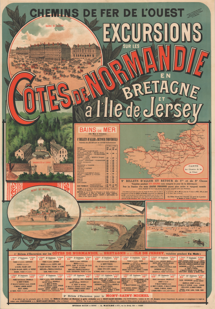


Title
Chemins de Fer de l'Ouest. Excursions sur les Côtes de Normandie en Bretagne et à l'Ile de Jersey.
1890 (undated) 40.5 x 28.25 in (102.87 x 71.755 cm) 1 : 1960000
1890 (undated) 40.5 x 28.25 in (102.87 x 71.755 cm) 1 : 1960000
Description
FOR THE ORIGINAL ANTIQUE MAP, WITH HISTORICAL ANALYSIS, CLICK HERE.
Digital Map Information
Geographicus maintains an archive of high-resolution rare map scans. We scan our maps at 300 DPI or higher, with newer images being 600 DPI, (either TIFF or JPEG, depending on when the scan was done) which is most cases in suitable for enlargement and printing.
Delivery
Once you purchase our digital scan service, you will receive a download link via email - usually within seconds. Digital orders are delivered as ZIP files, an industry standard file compression protocol that any computer should be able to unpack. Some of our files are very large, and can take some time to download. Most files are saved into your computer's 'Downloads' folder. All delivery is electronic. No physical product is shipped.
Credit and Scope of Use
You can use your digial image any way you want! Our digital images are unrestricted by copyright and can be used, modified, and published freely. The textual description that accompanies the original antique map is not included in the sale of digital images and remains protected by copyright. That said, we put significant care and effort into scanning and editing these maps, and we’d appreciate a credit when possible. Should you wish to credit us, please use the following credit line:
Courtesy of Geographicus Rare Antique Maps (https://www.geographicus.com).
How Large Can I Print?
In general, at 300 DPI, you should at least be able to double the size of the actual image, more so with our 600 DPI images. So, if the original was 10 x 12 inches, you can print at 20 x 24 inches, without quality loss. If your display requirements can accommodate some loss in image quality, you can make it even larger. That being said, no quality of scan will allow you to blow up at 10 x 12 inch map to wall size without significant quality loss. For more information, it is best consult a printer or reprographics specialist.
Refunds
If the high resolution image you ordered is unavailable, we will fully refund your purchase. Otherwise, digital images scans are a service, not a tangible product, and cannot be returned or refunded once the download link is used.
Cartographer
Adolphe Charles Maulde (September 14, 1796 - October 21, 1858) was a French bookseller, printer, and publisher based in Paris. He began as a bookseller in 1828 and quickly established himself as a leader in the industry, becoming the director and one of the owners of Affiches Parisiennes and a representative of the Chambre syndicale patronale (a group of Parisian printers and publishers). In 1836, he began printing as well as selling books, going into business with Stanislas Théophile Renou (1805 - 1872). Maulde et Renou became a leading printer of letterpress, sales catalogs, legal memoranda, and short published works, as well as broadsides and posters. In 1857, Renou took over the business and adopted lithographic printing. After Renou's death, his widow evidently took over the business in tandem with a new partner, the company being renamed Vves Renou, Maulde et Cock in 1873, then to Vve Renou et Maulde in 1885. It then became Typographie et lithographie A. Maulde et Cie (often simply reverting to 'Imprimerie Maulde et Renou') in 1888, and then, in 1895, Maulde, Doumenc et Cie, suggesting a new leader of the firm. Under this name, the firm continued to print a wide variety of works (including maps) until about 1920. More by this mapmaker...
References
OCLC 1135260471.