1890 Maulde Railway Poster w/ Map and Vignettes, Normandy and Bretagne
Normandie-maulde-1890$1,500.00


Title
Chemins de Fer de l'Ouest. Excursions sur les Côtes de Normandie en Bretagne et à l'Ile de Jersey.
1890 (undated) 40.5 x 28.25 in (102.87 x 71.755 cm) 1 : 1960000
1890 (undated) 40.5 x 28.25 in (102.87 x 71.755 cm) 1 : 1960000
Description
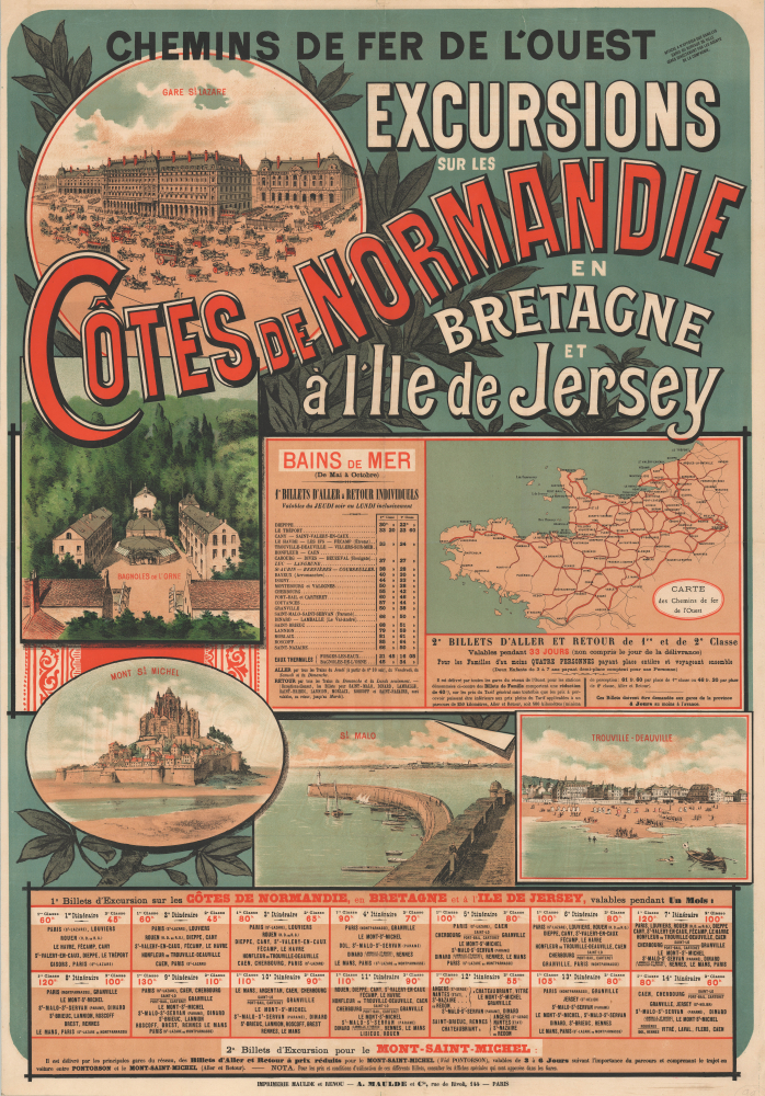
This stunning promotional chromolithograph travel poster of Normandy and Brittany, France, was prepared by A. Maulde et Cie for the Chemins de Fer de l'Ouest (Railroad of the West). Produced in a highly distinctive fin-de-siècle style, it reflects the development of rail infrastructure and the emergence of these areas as tourist destinations in the late 19th century.
The dazzling vignette illustrations include: the Gare St. Lazare in Paris, the terminus of many lines originating in Normandy and Brittany (the other being Gare Montparnasse); Bagnoles de l'Orne, a popular spa resort; the spectacular abbey of Mont St. Michel; the historic walled city (and pirate haven) of St. Malo; and the posh seaside resort towns of Trouville and Deauville near the Seine Estuary, sometimes known as the 'queen of the beaches' or the 'Parisian Riviera.'
Normandy and Brittany became increasingly popular tourist destinations in the late 19th century in large part thanks to the railways, as well as a growing middle class in Paris and other cities, and the championing of the regions in the work of leading writers and artists of the day, such as Victor Hugo (1802 - 1885), Gustave Flaubert (1821 - 1880, who was from Rouen), and Marcel Proust (1871 - 1922, who set much of his masterpiece À la recherche du temps perdu in Normandy's beachside resorts).
Despite these solid bases for revenue and their eye-catching advertisements, such as that seen here, the company ran into financial and operational problems around the turn of the century. In an infamous 1895 derailment, a train running late came into Gare Montparnasse at far too high a speed, plowed through the buffer stop at the end of the track, and right on through the station's wall, leading to the locomotive falling one story to the street below. A photograph of the crash taken by the firm Lévy and Sons became one of the most famous in transportation history, but the incident badly harmed the company's reputation.
A more enduring problem was that passenger traffic on the line was highly seasonal, thriving in the summer months but moribund the rest of the year, with the company's lines mostly passing through sparsely inhabited farmland on the way to beachside resort towns. Thus, in 1908, the company was nationalized and merged into the Chemins de fer de l'État, which itself became part of the newly-formed SNCF (Société nationale des chemins de fer français) in 1938.
In any event, this poster is very rare, as the stamp at top-right explains; 'Poster to be displayed only in stations or city offices managed directly by the company's agents.' Being an ephemeral promotional piece, very few of these posters have survived; we are aware of only one other example, held by the Bibliothèque nationale de France (which dates it c. 1890).
A Closer Look
This striking promotional poster consists of a railway map at right, a series of vignette illustrations, and several tables with information on fares and itineraries. The rail map displays the various lines of the Chemins de fer de l'Ouest network emanating from Paris. Main lines are traced in bold red lines, while secondary lines are sketched in thinner red lines, and the lines of competing railways are traced in black. In addition to rail lines, the Seine and Loire Rivers are illustrated.The dazzling vignette illustrations include: the Gare St. Lazare in Paris, the terminus of many lines originating in Normandy and Brittany (the other being Gare Montparnasse); Bagnoles de l'Orne, a popular spa resort; the spectacular abbey of Mont St. Michel; the historic walled city (and pirate haven) of St. Malo; and the posh seaside resort towns of Trouville and Deauville near the Seine Estuary, sometimes known as the 'queen of the beaches' or the 'Parisian Riviera.'
Chemins de fer de l'Ouest
Chemins de fer de l'Ouest began as the Compagnie de l'Ouest in 1855 when several small railways were merged, including the Paris - Le Pecq line, opened in 1837 as France's first purely passenger rail line. The company's lines served a few distinct purposes and groups of passengers, from daily commuters in Paris' western suburbs to long-distance travelers, the latter including summer tourists heading to resort towns on the English Channel or the Atlantic Coast. Larger cities like Le Havre, Rennes, and Nantes were connected with Paris by the early 1850s, and more cities acquired stops along the lines in the following decades.Normandy and Brittany became increasingly popular tourist destinations in the late 19th century in large part thanks to the railways, as well as a growing middle class in Paris and other cities, and the championing of the regions in the work of leading writers and artists of the day, such as Victor Hugo (1802 - 1885), Gustave Flaubert (1821 - 1880, who was from Rouen), and Marcel Proust (1871 - 1922, who set much of his masterpiece À la recherche du temps perdu in Normandy's beachside resorts).
Despite these solid bases for revenue and their eye-catching advertisements, such as that seen here, the company ran into financial and operational problems around the turn of the century. In an infamous 1895 derailment, a train running late came into Gare Montparnasse at far too high a speed, plowed through the buffer stop at the end of the track, and right on through the station's wall, leading to the locomotive falling one story to the street below. A photograph of the crash taken by the firm Lévy and Sons became one of the most famous in transportation history, but the incident badly harmed the company's reputation.
A more enduring problem was that passenger traffic on the line was highly seasonal, thriving in the summer months but moribund the rest of the year, with the company's lines mostly passing through sparsely inhabited farmland on the way to beachside resort towns. Thus, in 1908, the company was nationalized and merged into the Chemins de fer de l'État, which itself became part of the newly-formed SNCF (Société nationale des chemins de fer français) in 1938.
Chromolithography
Chromolithography, sometimes called oleography, is a color lithographic technique developed in the mid-19th century. The process involved using multiple lithographic stones, one for each color, to yield a rich composite effect. Oftentimes, the process would start with a black basecoat upon which subsequent colors were layered. Some chromolithographs used 30 or more separate lithographic stones to achieve the desired product. Chromolithograph color could also be effectively blended for even more dramatic results. The process became extremely popular in the late 19th and early 20th centuries when it emerged as the dominant method of color printing. The vivid color chromolithography produced made it exceptionally effective for advertising and propaganda imagery.Publication History and Census
This work was printed by A. Maulde et Cie for Chemins de fer de l'Ouest. It is undated, but from the style, content, and name of the company (which became Maulde, Doumenc et Cie in 1895), we can posit a date in the early 1890s. Although not credited here, it is possible that this poster was designed by French-Belgian artist Gustave Fraipont (1849 - 1923), whose credited works include several posters in this style (some with the same exact title) done for Chemins de fer de l'Ouest. Alternatively, it could have been created by other artists employed by the railway around the same time, such as Hugo d'Alési (1849 - 1906) or Lucien Lefèvre (1850 - 1902).In any event, this poster is very rare, as the stamp at top-right explains; 'Poster to be displayed only in stations or city offices managed directly by the company's agents.' Being an ephemeral promotional piece, very few of these posters have survived; we are aware of only one other example, held by the Bibliothèque nationale de France (which dates it c. 1890).
Cartographer
Adolphe Charles Maulde (September 14, 1796 - October 21, 1858) was a French bookseller, printer, and publisher based in Paris. He began as a bookseller in 1828 and quickly established himself as a leader in the industry, becoming the director and one of the owners of Affiches Parisiennes and a representative of the Chambre syndicale patronale (a group of Parisian printers and publishers). In 1836, he began printing as well as selling books, going into business with Stanislas Théophile Renou (1805 - 1872). Maulde et Renou became a leading printer of letterpress, sales catalogs, legal memoranda, and short published works, as well as broadsides and posters. In 1857, Renou took over the business and adopted lithographic printing. After Renou's death, his widow evidently took over the business in tandem with a new partner, the company being renamed Vves Renou, Maulde et Cock in 1873, then to Vve Renou et Maulde in 1885. It then became Typographie et lithographie A. Maulde et Cie (often simply reverting to 'Imprimerie Maulde et Renou') in 1888, and then, in 1895, Maulde, Doumenc et Cie, suggesting a new leader of the firm. Under this name, the firm continued to print a wide variety of works (including maps) until about 1920. More by this mapmaker...
Condition
Very good. Laid down on linen, possibly original.
References
OCLC 1135260471.