This item has been sold, but you can get on the Waitlist to be notified if another example becomes available, or purchase a digital scan.
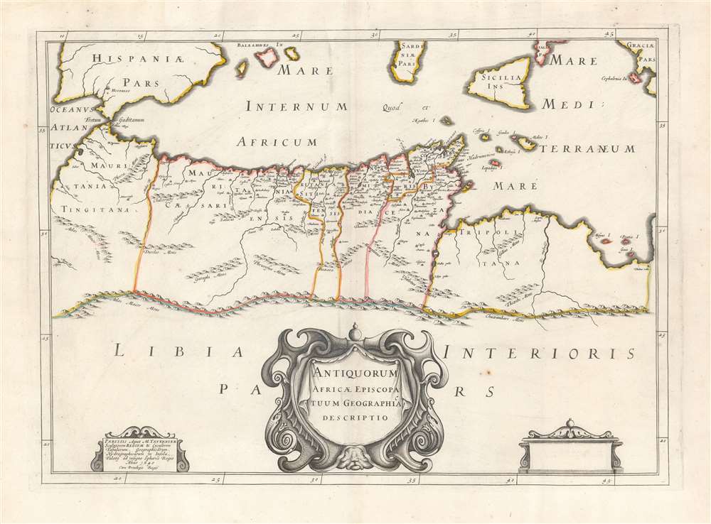
1640 Tavernier Map of North Africa of the Roman Empire
NorthAfrica-tavernier-1640$225.00

Title
Antiquorum Africae Episcopatuum Geographica Descriptio.
1640 (dated) 14.5 x 20 in (36.83 x 50.8 cm) 1 : 10101000
1640 (dated) 14.5 x 20 in (36.83 x 50.8 cm) 1 : 10101000
Description
This scarce 1641 Tavernier map of Northern Africa and the Mediterranean Sea was produced for the first edition of Charles Vialart's Geographica Sacra, to illustrate the African bishoprics of the early Christian church.
The Church in Africa
Vialart's work was meant to be a religious and geographical atlas of the Catholic world, both ancient and modern. Its maps focused on the areas that fell under the Catholic aegis going back to the Roman era. This specific map focused on the reach of the Catholic Church in Roman Africa. Consequently, detail of the map extends only as far south as the Atlas Mountains, which were the limit of Roman understanding in the continent. (Control of Rome's Legionaries was more limited: their practical power extended at most to the Sala Colonia (visible on this map on the Sala Fl on the western coast of the province of Mauritania Tingitana)).A Closer Look
The cities noted, primarily in that province and in Mauritania Caesariensis, are well north of the Atlas Mountains. Part of Spain, the Balearic Islands, Sardinia, and Sicily are all visible, along with Malta and the other islands forming the archipelago between Carthage and Sicily.Publication History and Census
This map was engraved by Melchior Tavernier in 1640 for inclusion in Charles Vialart's 1641 Geographica Sacra, which was also printed in Tavernier's shop. The map was later copied by Nicolas Sanson, and thereafter saw editions printed in Amsterdam by Pierre Mortier and later still by François Halma. Geographica Sacra appears in about thirty institutional collections. The separate map appears less frequently.Cartographer
Melchior Tavernier I (1564 - 1641) was a French engraver of Flemish descent. Born in Antwerp, he was the son of Gabriel Tavernier and father of Melchior Tavernier II (1584 – 1665). He may have studied under Ortelius in Antwerp. His father Gabriel Tavernier is credited for introducing the roller press to Paris. He had the distinction of being Imprimeur en Tailles-douces de la Maison de Sa Majesté. Tavernier's workshop was located near the Pont Marchand, where apparently several other printers, including Gobert and Collet, also maintained businesses. Melchior Tavernier is the brother of the celebrated writer and traveler Jean-Baptiste Tavernier (1605-1689). Tavernier engraved several important maps for figures such as Samuel de Champlain, and others. Melchior Tavernier II's work is difficult to distinguish from that of his son, Melchior Tavernier II. More by this mapmaker...
Source
Vialart, C., Geographica Sacra, (Tavernier) 1641.
Condition
Fine. Generous margins and original outline color.
References
OCLC 796354284. Not in Afriterra. Not in Norwich.