Digital Image: 1640 Tavernier Map of North Africa of the Roman Empire
NorthAfrica-tavernier-1640_d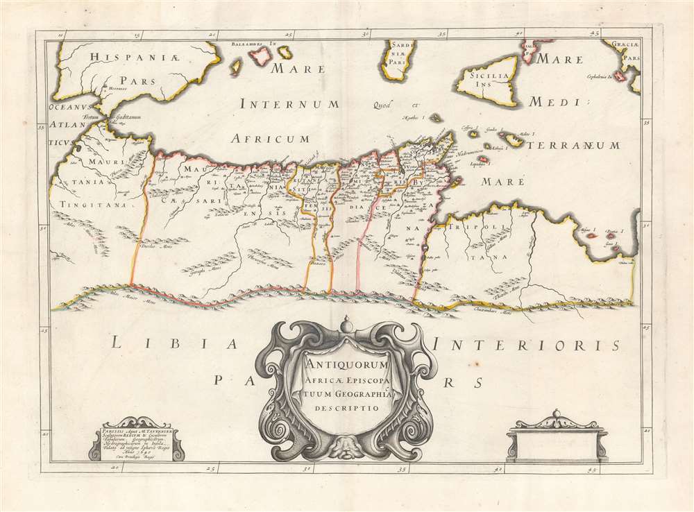

Title
Antiquorum Africae Episcopatuum Geographica Descriptio.
1640 (dated) 14.5 x 20 in (36.83 x 50.8 cm) 1 : 10101000
1640 (dated) 14.5 x 20 in (36.83 x 50.8 cm) 1 : 10101000
Description
FOR THE ORIGINAL ANTIQUE MAP, WITH HISTORICAL ANALYSIS, CLICK HERE.
Digital Map Information
Geographicus maintains an archive of high-resolution rare map scans. We scan our maps at 300 DPI or higher, with newer images being 600 DPI, (either TIFF or JPEG, depending on when the scan was done) which is most cases in suitable for enlargement and printing.
Delivery
Once you purchase our digital scan service, you will receive a download link via email - usually within seconds. Digital orders are delivered as ZIP files, an industry standard file compression protocol that any computer should be able to unpack. Some of our files are very large, and can take some time to download. Most files are saved into your computer's 'Downloads' folder. All delivery is electronic. No physical product is shipped.
Credit and Scope of Use
You can use your digial image any way you want! Our digital images are unrestricted by copyright and can be used, modified, and published freely. The textual description that accompanies the original antique map is not included in the sale of digital images and remains protected by copyright. That said, we put significant care and effort into scanning and editing these maps, and we’d appreciate a credit when possible. Should you wish to credit us, please use the following credit line:
Courtesy of Geographicus Rare Antique Maps (https://www.geographicus.com).
How Large Can I Print?
In general, at 300 DPI, you should at least be able to double the size of the actual image, more so with our 600 DPI images. So, if the original was 10 x 12 inches, you can print at 20 x 24 inches, without quality loss. If your display requirements can accommodate some loss in image quality, you can make it even larger. That being said, no quality of scan will allow you to blow up at 10 x 12 inch map to wall size without significant quality loss. For more information, it is best consult a printer or reprographics specialist.
Refunds
If the high resolution image you ordered is unavailable, we will fully refund your purchase. Otherwise, digital images scans are a service, not a tangible product, and cannot be returned or refunded once the download link is used.
Cartographer
Melchior Tavernier I (1564 - 1641) was a French engraver of Flemish descent. Born in Antwerp, he was the son of Gabriel Tavernier and father of Melchior Tavernier II (1584 – 1665). He may have studied under Ortelius in Antwerp. His father Gabriel Tavernier is credited for introducing the roller press to Paris. He had the distinction of being Imprimeur en Tailles-douces de la Maison de Sa Majesté. Tavernier's workshop was located near the Pont Marchand, where apparently several other printers, including Gobert and Collet, also maintained businesses. Melchior Tavernier is the brother of the celebrated writer and traveler Jean-Baptiste Tavernier (1605-1689). Tavernier engraved several important maps for figures such as Samuel de Champlain, and others. Melchior Tavernier II's work is difficult to distinguish from that of his son, Melchior Tavernier II. More by this mapmaker...
Source
Vialart, C., Geographica Sacra, (Tavernier) 1641.
References
OCLC 796354284. Not in Afriterra. Not in Norwich.