Digital Image: 1698 Louis Hennepin Map of North America
NorthAmerica-hennepin-1698_d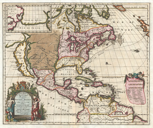

Title
Amerique Septentrionalis Carte d'un tres grand Pays entre le Nouveau Mexique et la Mer Glaciace Dediee a Guilliaume IIIe. Roy de La Grand Bretagne Par le R. P. Louis de Hennepin Mission: Recol: et Not: Apost: Chez c. Specht a Utreght 1698.
1698 (dated) 17.5 x 21 in (44.45 x 53.34 cm)
1698 (dated) 17.5 x 21 in (44.45 x 53.34 cm)
Description
FOR THE ORIGINAL ANTIQUE MAP, WITH HISTORICAL ANALYSIS, CLICK HERE.
Digital Map Information
Geographicus maintains an archive of high-resolution rare map scans. We scan our maps at 300 DPI or higher, with newer images being 600 DPI, (either TIFF or JPEG, depending on when the scan was done) which is most cases in suitable for enlargement and printing.
Delivery
Once you purchase our digital scan service, you will receive a download link via email - usually within seconds. Digital orders are delivered as ZIP files, an industry standard file compression protocol that any computer should be able to unpack. Some of our files are very large, and can take some time to download. Most files are saved into your computer's 'Downloads' folder. All delivery is electronic. No physical product is shipped.
Credit and Scope of Use
You can use your digial image any way you want! Our digital images are unrestricted by copyright and can be used, modified, and published freely. The textual description that accompanies the original antique map is not included in the sale of digital images and remains protected by copyright. That said, we put significant care and effort into scanning and editing these maps, and we’d appreciate a credit when possible. Should you wish to credit us, please use the following credit line:
Courtesy of Geographicus Rare Antique Maps (https://www.geographicus.com).
How Large Can I Print?
In general, at 300 DPI, you should at least be able to double the size of the actual image, more so with our 600 DPI images. So, if the original was 10 x 12 inches, you can print at 20 x 24 inches, without quality loss. If your display requirements can accommodate some loss in image quality, you can make it even larger. That being said, no quality of scan will allow you to blow up at 10 x 12 inch map to wall size without significant quality loss. For more information, it is best consult a printer or reprographics specialist.
Refunds
If the high resolution image you ordered is unavailable, we will fully refund your purchase. Otherwise, digital images scans are a service, not a tangible product, and cannot be returned or refunded once the download link is used.
Cartographer
Antoine Louis Hennepin (May 12, 1626 - December 5, 1704) was a Catholic priest and missionary of the Franciscan Recollect order. Born in 1626 in Ath in the Spanish Netherlands, the son of a butcher. He joined the Franciscan covenant of Béthune (Pas-de-Calais) at 17, where he studied under Father Gabriel de la Ribourde. Latter he transferred to the convent of Maontargis (Loriet), where he completed his religious studies under Father Paul Huet. He entered the priesthood immediacy after. He is best known as an explorer of the interior of North America. After entering the Catholic Church he was assigned to the coast of France, where he remained until 1675. The stories he heard from sailors returning from North America intrigued him to such degree that he himself made the journey across the Atlantic. Hennepin arrived in New France as a Recollect Missionary and was selected as the scribe and chronicler for Robert Cavelier La Salle's 1678 expedition from Fort Frontenac to the Great Lakes. Hennepin, who had a passion for 'pure and severe virtue' and La Salle, who had a passion for 'moral weaknesses' never quite saw eye to eye. Nonetheless, in 1680 La Salle sent Hennepin, along with two woodsmen, to search out the source of the Mississippi. Hennepin travelled down the Illinois River as far as the Mississippi, where he passed present-day Minneapolis. Among the many firsts on this journey was the discovery and naming of St. Anthony Falls, the only cataract on the Mississippi. Hennepin then traveled northwards to Lac des Issatis, or Leach Lake, which he asserted was the source of the Father of Rivers, a term he also claims (falsely) to have coined. Though Leach Lake is a source of the Mississippi it is not generally considered to be the source. On his return journey Hennepin was taken prisoner by a wandering band of Sioux Indians who took him into the Mille Lacs region of Minnesota. Hennepin remained in Sioux custody until September of 1680 when the adventurer Daneil Greysolon Delhut, who had negotiated a peace treaty with the Sioux, ransomed him. In 1681, Hennepin began writing his first book, Description de la Louisiane, which he dedicated to Louis XIV of France, and which described the achievements of the La Salle Expedition. Hennepin's book proved to be an enormous success that significantly impact on the cartographic history of America. It is also contains the first European image of Niagara Falls. Ten years later La Salle was assassinated in modern day Texas by Pierre Duhaut. Meanwhile, Hennepin, perhaps seeing an opportunity for self-aggrandizement, fled to England where he published another book, Nouvelle Decouverte d'un tres grand Pays Situe dans L'Amerique, dedicated to William III of England. This book reaffirmed, with some controversy, Hennepin's own contribution to the discovery of North America. The false claims in Decouverte include, among other absurdities, spurious assertion that Hennepin explored the entire length of the Mississippi River. Like the first, Hennepin's second book also proved enormously popular and was influential in the mis-mapping of the Mississippi far westward of its actual location for the next 50 years. Decouverte also earned Hennepin the enmity of the French Crown and Louis XIV ordered that he be arrested if he ever attempted to return to New France. He later published a third, less important work that reasserted some of the content of the first two. Louis Hennepin died in Rome in 1705. More by this mapmaker...
Source
Hennepin, Louis, Nouvelle Decouverte d'un tres grand Pays, situe dans L'Amerique, entre le Nouveau Mexique et la Mer Glaciale, , (Utrecht), 1698 (Second edition). Also: Independent Issues, as here.