This item has been sold, but you can get on the Waitlist to be notified if another example becomes available, or purchase a digital scan.
1698 Louis Hennepin Map of North America
NorthAmerica-hennepin-1698$3,000.00

Title
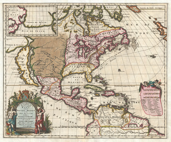
Amerique Septentrionalis Carte d'un tres grand Pays entre le Nouveau Mexique et la Mer Glaciace Dediee a Guilliaume IIIe. Roy de La Grand Bretagne Par le R. P. Louis de Hennepin Mission: Recol: et Not: Apost: Chez c. Specht a Utreght 1698.
1698 (dated) 17.5 x 21 in (44.45 x 53.34 cm)
1698 (dated) 17.5 x 21 in (44.45 x 53.34 cm)
Description
A map that fundamentally impacted the cartographic history of America, this is the 1698 Friar Hennepin map of North America. Covering all of North America from the Equator to the Arctic, this map is remarkable on a number of levels including its depiction of California as an Island, the addition of Terre de Iesso in the extreme northwest, the presence of Lake Apalache in the southeast, the inclusion of Lake Parima and El Dorado in South America, and the suggestion of a Northwest Passage. However, it is best known for its remarkable and highly influential rendering of the Great Lakes and the Mississippi Valley.
In 1679 the French lord René-Robert Cavelier de La Salle set out from Fort Frontenac, on Lake Ontario, to explore the Great Lakes and eventually make his way into the Mississippi River. La Salle was of the belief that the Mississippi connected to other water routes that would eventually lead to the Pacific. His scribe and chronicler on this expedition was a Dutch Friar of the Franciscan Recollect order, Antoine Louis Hennepin. Hennepin, who had a passion for 'pure and severe virtue' and La Salle, who had a passion for 'moral weaknesses' never quite saw eye to eye. Nonetheless, the expedition sailed (and were the first to do so) through Lake Ontario, Lake Erie, and Lake Huron into Lake Michigan, then followed the St. Joseph River to what is today South Bend Indiana, where they constructed Fort Crevecoeur, present day Peoria, Illinois. At this point the explorers parted ways with La Salle returning on foot to Frontenac to resupply and Hennepin continuing onward via the Illinois River to the Mississippi.
Hennepin attempted to explore southwards towards the mouth of the Mississippi but, in his own words, 'the nations did not give us the time to navigate up and down this river.' Instead he traveled northward past St. Anthony Falls and modern day Minneapolis to Lac des Issatis (Leech Lake), a source of the Mississippi. From here Hennepin attempted a return to Fort Crevecoeur, but was instead captured by a band of wandering Sioux who took him to the Mille Lacs region of Minnesota, near Lake Superior. Hennepin remained in Sioux custody until the adventurer Daneil Greysolon Delhut, who had negotiated a peace treaty with the Sioux, ransomed him.
Hennepin and La Salle never met again. La Salle went on to explore the length of the Mississippi, named Louisiana, claimed it for France, and established a short lived colony near Matagorda Bay, Texas. Hennepin, who had enough adventure, returned to France where he published an enormously popular book, Description de la Louisiane. This book featured a map that depicted a speculative course of the Mississippi, but did not suggest any exploration of the southward path of the River beyond it conjunction with the Illinois.
Ten years later La Salle was been assassinated in modern day Texas by Pierre Duhaut. Meanwhile, Hennepin, perhaps seeing an opportunity for self-aggrandizement, fled to England (it is William III of England who's arms appear in the title cartouche of this map) where he published another book, Nouvelle Decouverte d'un tres grand Pays Situe dans L'Amerique and another map – this one. In his second major work Hennepin suggested that, for fear of La Salle, he had hidden the full extent of his explorations:
Though partially fictional, Hennepin's narratives were enormously popular and influential. Firstly, they established that the Mississippi did indeed flow into the Gulf of Mexico. Secondly, Hennepin mapped the course of the Mississippi far west of its actual location, putting its mouth somewhere near modern day Corpus Christi. This was a curious choice for, even La Salle, who founded a colony on Matagorda Bay, knew to look for the Mississippi to the east. Nonetheless, Hennepin maps the mouth of the Mississippi to the west of La Salle's colony; a decision would ultimately expand the French claims in Louisiana dramatically. Though the mouth of the Mississippi was finally discovered in 1699 by Pierre Le Moyne d'Iberville, the French maintained their claim to the enormous Louisiana. Over one hundred years later, when the fledgling United States acquired the vast Louisiana Territory from Napoleon Bonaparte, Hennepin's map and La Salle's claims prompted some to suggest that Louisiana included (or at least should have) Texas, leading to the Mexican-American war and the U.S. Annexation of Texas.
Hennepin's representation of the Great Lakes is also a significant advance over that of Sanson. The lakes are slowly beginning to take on a somewhat realistic form though territorially are significantly larger than life. Hennepin was a major proponent of the idea that a navigable water route to the Pacific was available via the inland waterways. On this map he suggests two such routes, one up the Missouri and then down the Tecon into the Gulf of California and another via the Mer Glacial and the Hudson Bay.
In accordance with prevalent theory of the period, California is depicted as an island. The idea of an insular California first appeared as a work of fiction in Garci Rodriguez de Montalvo's c. 1510 romance Las Sergas de Esplandian, where he writes
In the extreme northwest, just above insular California and in an inset in the upper left quadrant, we come across a mysterious land labeled 'Terre de Iesso.' Though Yesso or Jesso is a name traditionally associated with Hokkaido (which here is drawn as part of mainland Asia), this land mass is more commonly called Gama or Gamaland. Gama was supposedly discovered in the 17th century by a mysterious figure known as Jean de Gama. Various subsequent navigators claim to have seen this land and it appeared on numerous maps well into the late 18th century. At times it was associated with Hokkaido, in Japan, and at other times with the mainland of North America. Hennepin curiously maps it as a large insular landmass dividing America and Asia, which strongly advocates for his belief that access to the wealth of Japan and China was but a step away from the western shores of North America.
This map extends southward just beyond the Equator to the Amazon River just taking in enough territory to include Lake Parima, near modern day Guyana and northern Brazil. Parima and the city of Manoa, here called 'Dorado Mancael', was first identified by Sr. Walter Raleigh in 1595. Raleigh does not visit the city of Manoa (which he believes is El Dorado) himself due to the onset of the rainy season, however he describes the city, based on indigenous accounts, as resting on a salt lake over 200 leagues wide. This lake, though no longer mapped as such, does have some basis in fact. Parts of the Amazon were, at the time, dominated by a large and powerful indigenous trading nation known as the Manoa. The Manoa traded the length and breadth of the Amazon. The onset of the rainy season inundated the great savannahs of the Rupununi, Takutu, and Rio Branco or Parima Rivers. This inundation briefly connected the Amazon and Orinoco river systems, opening an annual and well used trade route for the Manoans. The Manoans who traded with the Incans in the western Amazon, had access to gold mines on the western slopes of the Andes, and so, when Raleigh saw gold rich Indian traders arriving in Guyana, he made the natural assumption for a gold hungry European in search of El Dorado. When he asked the Orinocans where the traders were from, they could only answer, 'Manoa.' Thus did Lake Parime or Parima and the city of Manoa begin to appear on maps in the early 17th-century. The city of Manoa and Lake Parima would continue to be mapped in this area until about 1800.
This map was issued in several editions and numerous different states. The first edition, first state was issued in 1697 in Utrecht by Chez G. Broedelet. This was black and white map that was issued in conjunction with Nouvelle Decouverte d'un tres grand Pays Situe dans L'Amerique. Subsequent editions of Nouvelle Decouverte were later published in Amsterdam, Utrecht, and Leiden by A. v. Someren, Ches Pierre van der As, and Chez C. Specht. This example is the second edition by Specht. It is identifiable as such by some of the cartographic detail in Florida, the enlargement of the scale cartouche to accommodate a list of European possessions in America in the lower right, and the addition of the text 'Amerique Septentrionale' at the top of the title. All examples of this map that were issued in conjunction with Hennepin's book were issued without color. This example is thusly exceptionally rare due to its early highly detailed color work that includes gold leafing to highlight important cities and the Tropic of Cancer. It is our belief that this is one of the few examples of this map prepared by Specht independently and elaborately colored for issue in composite atlases.
In 1679 the French lord René-Robert Cavelier de La Salle set out from Fort Frontenac, on Lake Ontario, to explore the Great Lakes and eventually make his way into the Mississippi River. La Salle was of the belief that the Mississippi connected to other water routes that would eventually lead to the Pacific. His scribe and chronicler on this expedition was a Dutch Friar of the Franciscan Recollect order, Antoine Louis Hennepin. Hennepin, who had a passion for 'pure and severe virtue' and La Salle, who had a passion for 'moral weaknesses' never quite saw eye to eye. Nonetheless, the expedition sailed (and were the first to do so) through Lake Ontario, Lake Erie, and Lake Huron into Lake Michigan, then followed the St. Joseph River to what is today South Bend Indiana, where they constructed Fort Crevecoeur, present day Peoria, Illinois. At this point the explorers parted ways with La Salle returning on foot to Frontenac to resupply and Hennepin continuing onward via the Illinois River to the Mississippi.
Hennepin attempted to explore southwards towards the mouth of the Mississippi but, in his own words, 'the nations did not give us the time to navigate up and down this river.' Instead he traveled northward past St. Anthony Falls and modern day Minneapolis to Lac des Issatis (Leech Lake), a source of the Mississippi. From here Hennepin attempted a return to Fort Crevecoeur, but was instead captured by a band of wandering Sioux who took him to the Mille Lacs region of Minnesota, near Lake Superior. Hennepin remained in Sioux custody until the adventurer Daneil Greysolon Delhut, who had negotiated a peace treaty with the Sioux, ransomed him.
Hennepin and La Salle never met again. La Salle went on to explore the length of the Mississippi, named Louisiana, claimed it for France, and established a short lived colony near Matagorda Bay, Texas. Hennepin, who had enough adventure, returned to France where he published an enormously popular book, Description de la Louisiane. This book featured a map that depicted a speculative course of the Mississippi, but did not suggest any exploration of the southward path of the River beyond it conjunction with the Illinois.
Ten years later La Salle was been assassinated in modern day Texas by Pierre Duhaut. Meanwhile, Hennepin, perhaps seeing an opportunity for self-aggrandizement, fled to England (it is William III of England who's arms appear in the title cartouche of this map) where he published another book, Nouvelle Decouverte d'un tres grand Pays Situe dans L'Amerique and another map – this one. In his second major work Hennepin suggested that, for fear of La Salle, he had hidden the full extent of his explorations:
This is where I would like all the world to know the mystery of this discovery that I have hidden until now so as not to inflict sorrow on Sieur de La Salle, who wanted all the glory and secret knowledge of this discovery for himself alone. This is why he sacrificed several persons to prevent them from publishing what they had seen and from foiling his secret plans.In his second enormously popular work; Hennepin claimed that he had explored the full length of the Mississippi before La Salle. Hennepin's fanciful and inaccurate account of this voyage as well as his claim of discovering the mouth of the Mississippi have been refuted as spurious by Andrew Ellicott and others. The simple fact is, despite his claims, Hennepin did not have enough time to navigate the length of the Mississippi. Most likely Hennepin drew the details of his narrative from the work of the missionaries Jacques Marquette and Louis Joliet, who had been active in the region several decades earlier.
Though partially fictional, Hennepin's narratives were enormously popular and influential. Firstly, they established that the Mississippi did indeed flow into the Gulf of Mexico. Secondly, Hennepin mapped the course of the Mississippi far west of its actual location, putting its mouth somewhere near modern day Corpus Christi. This was a curious choice for, even La Salle, who founded a colony on Matagorda Bay, knew to look for the Mississippi to the east. Nonetheless, Hennepin maps the mouth of the Mississippi to the west of La Salle's colony; a decision would ultimately expand the French claims in Louisiana dramatically. Though the mouth of the Mississippi was finally discovered in 1699 by Pierre Le Moyne d'Iberville, the French maintained their claim to the enormous Louisiana. Over one hundred years later, when the fledgling United States acquired the vast Louisiana Territory from Napoleon Bonaparte, Hennepin's map and La Salle's claims prompted some to suggest that Louisiana included (or at least should have) Texas, leading to the Mexican-American war and the U.S. Annexation of Texas.
Hennepin's representation of the Great Lakes is also a significant advance over that of Sanson. The lakes are slowly beginning to take on a somewhat realistic form though territorially are significantly larger than life. Hennepin was a major proponent of the idea that a navigable water route to the Pacific was available via the inland waterways. On this map he suggests two such routes, one up the Missouri and then down the Tecon into the Gulf of California and another via the Mer Glacial and the Hudson Bay.
In accordance with prevalent theory of the period, California is depicted as an island. The idea of an insular California first appeared as a work of fiction in Garci Rodriguez de Montalvo's c. 1510 romance Las Sergas de Esplandian, where he writes
Know, that on the right hand of the Indies there is an island called California very close to the side of the Terrestrial Paradise; and it is peopled by black women, without any man among them, for they live in the manner of Amazons.Baja California was subsequently discovered in 1533 by Fortun Ximenez, who had been sent to the area by Hernan Cortez. When Cortez himself traveled to Baja, he must have had Montalvo's novel in mind, for he immediately claimed the 'Island of California' for the King. By the late 16th and early 17th century ample evidence had been amassed, through explorations of the region by Francisco de Ulloa, Hernando de Alarcon and others, that California was in fact a peninsula. However, by this time other factors were in play. Francis Drake had sailed north and claimed 'New Albion' near modern day Washington or Vancouver for England. The Spanish thus needed to promote Cortez's claim on the 'Island of California' to preempt English claims on the western coast of North America. The significant influence of the Spanish crown on European cartographers caused a major resurgence of the Insular California theory. Shortly after this map was made Eusebio Kino, a Jesuit missionary, traveled overland from Mexico to California, proving conclusively the peninsularity of California.
In the extreme northwest, just above insular California and in an inset in the upper left quadrant, we come across a mysterious land labeled 'Terre de Iesso.' Though Yesso or Jesso is a name traditionally associated with Hokkaido (which here is drawn as part of mainland Asia), this land mass is more commonly called Gama or Gamaland. Gama was supposedly discovered in the 17th century by a mysterious figure known as Jean de Gama. Various subsequent navigators claim to have seen this land and it appeared on numerous maps well into the late 18th century. At times it was associated with Hokkaido, in Japan, and at other times with the mainland of North America. Hennepin curiously maps it as a large insular landmass dividing America and Asia, which strongly advocates for his belief that access to the wealth of Japan and China was but a step away from the western shores of North America.
This map extends southward just beyond the Equator to the Amazon River just taking in enough territory to include Lake Parima, near modern day Guyana and northern Brazil. Parima and the city of Manoa, here called 'Dorado Mancael', was first identified by Sr. Walter Raleigh in 1595. Raleigh does not visit the city of Manoa (which he believes is El Dorado) himself due to the onset of the rainy season, however he describes the city, based on indigenous accounts, as resting on a salt lake over 200 leagues wide. This lake, though no longer mapped as such, does have some basis in fact. Parts of the Amazon were, at the time, dominated by a large and powerful indigenous trading nation known as the Manoa. The Manoa traded the length and breadth of the Amazon. The onset of the rainy season inundated the great savannahs of the Rupununi, Takutu, and Rio Branco or Parima Rivers. This inundation briefly connected the Amazon and Orinoco river systems, opening an annual and well used trade route for the Manoans. The Manoans who traded with the Incans in the western Amazon, had access to gold mines on the western slopes of the Andes, and so, when Raleigh saw gold rich Indian traders arriving in Guyana, he made the natural assumption for a gold hungry European in search of El Dorado. When he asked the Orinocans where the traders were from, they could only answer, 'Manoa.' Thus did Lake Parime or Parima and the city of Manoa begin to appear on maps in the early 17th-century. The city of Manoa and Lake Parima would continue to be mapped in this area until about 1800.
This map was issued in several editions and numerous different states. The first edition, first state was issued in 1697 in Utrecht by Chez G. Broedelet. This was black and white map that was issued in conjunction with Nouvelle Decouverte d'un tres grand Pays Situe dans L'Amerique. Subsequent editions of Nouvelle Decouverte were later published in Amsterdam, Utrecht, and Leiden by A. v. Someren, Ches Pierre van der As, and Chez C. Specht. This example is the second edition by Specht. It is identifiable as such by some of the cartographic detail in Florida, the enlargement of the scale cartouche to accommodate a list of European possessions in America in the lower right, and the addition of the text 'Amerique Septentrionale' at the top of the title. All examples of this map that were issued in conjunction with Hennepin's book were issued without color. This example is thusly exceptionally rare due to its early highly detailed color work that includes gold leafing to highlight important cities and the Tropic of Cancer. It is our belief that this is one of the few examples of this map prepared by Specht independently and elaborately colored for issue in composite atlases.
Cartographer
Antoine Louis Hennepin (May 12, 1626 - December 5, 1704) was a Catholic priest and missionary of the Franciscan Recollect order. Born in 1626 in Ath in the Spanish Netherlands, the son of a butcher. He joined the Franciscan covenant of Béthune (Pas-de-Calais) at 17, where he studied under Father Gabriel de la Ribourde. Latter he transferred to the convent of Maontargis (Loriet), where he completed his religious studies under Father Paul Huet. He entered the priesthood immediacy after. He is best known as an explorer of the interior of North America. After entering the Catholic Church he was assigned to the coast of France, where he remained until 1675. The stories he heard from sailors returning from North America intrigued him to such degree that he himself made the journey across the Atlantic. Hennepin arrived in New France as a Recollect Missionary and was selected as the scribe and chronicler for Robert Cavelier La Salle's 1678 expedition from Fort Frontenac to the Great Lakes. Hennepin, who had a passion for 'pure and severe virtue' and La Salle, who had a passion for 'moral weaknesses' never quite saw eye to eye. Nonetheless, in 1680 La Salle sent Hennepin, along with two woodsmen, to search out the source of the Mississippi. Hennepin travelled down the Illinois River as far as the Mississippi, where he passed present-day Minneapolis. Among the many firsts on this journey was the discovery and naming of St. Anthony Falls, the only cataract on the Mississippi. Hennepin then traveled northwards to Lac des Issatis, or Leach Lake, which he asserted was the source of the Father of Rivers, a term he also claims (falsely) to have coined. Though Leach Lake is a source of the Mississippi it is not generally considered to be the source. On his return journey Hennepin was taken prisoner by a wandering band of Sioux Indians who took him into the Mille Lacs region of Minnesota. Hennepin remained in Sioux custody until September of 1680 when the adventurer Daneil Greysolon Delhut, who had negotiated a peace treaty with the Sioux, ransomed him. In 1681, Hennepin began writing his first book, Description de la Louisiane, which he dedicated to Louis XIV of France, and which described the achievements of the La Salle Expedition. Hennepin's book proved to be an enormous success that significantly impact on the cartographic history of America. It is also contains the first European image of Niagara Falls. Ten years later La Salle was assassinated in modern day Texas by Pierre Duhaut. Meanwhile, Hennepin, perhaps seeing an opportunity for self-aggrandizement, fled to England where he published another book, Nouvelle Decouverte d'un tres grand Pays Situe dans L'Amerique, dedicated to William III of England. This book reaffirmed, with some controversy, Hennepin's own contribution to the discovery of North America. The false claims in Decouverte include, among other absurdities, spurious assertion that Hennepin explored the entire length of the Mississippi River. Like the first, Hennepin's second book also proved enormously popular and was influential in the mis-mapping of the Mississippi far westward of its actual location for the next 50 years. Decouverte also earned Hennepin the enmity of the French Crown and Louis XIV ordered that he be arrested if he ever attempted to return to New France. He later published a third, less important work that reasserted some of the content of the first two. Louis Hennepin died in Rome in 1705. More by this mapmaker...
Source
Hennepin, Louis, Nouvelle Decouverte d'un tres grand Pays, situe dans L'Amerique, entre le Nouveau Mexique et la Mer Glaciale, , (Utrecht), 1698 (Second edition). Also: Independent Issues, as here.
Condition
Very good condition. Upper margin extended. Verso reinforcement on centerfold.
References
McCorkle, B., New England in Early Printed Maps 1513-1800: An Illustrated Carto-Bibliography, 697.2. McLaughlin, G., The Mapping of California as an Island: An Illustrated Checklist, 124-3. Goss, J., The Mapping of North America: Three Centuries of Map-Making 1500-1860, #47. Tooley, R. V., The Mapping of America, p. 125. Winsor, Justin, Narrative and Critical History of America, vol IV, pp. 247-256. Cumming, W. P., The Exploration of North America, 1640 - 1776, pl. 79. Karpinski, L. C., Maps of Famous Cartographers Depicting North America, p.100. Kaufman, K., The Mapping of the Great Lakes in the Seventeenth Century: Twenty-Two Maps from the George S. and Nancy B. Parker Collection, #20.