
This item below is out of stock, but another example (left) is available. To view the available item, click "Details."
Details
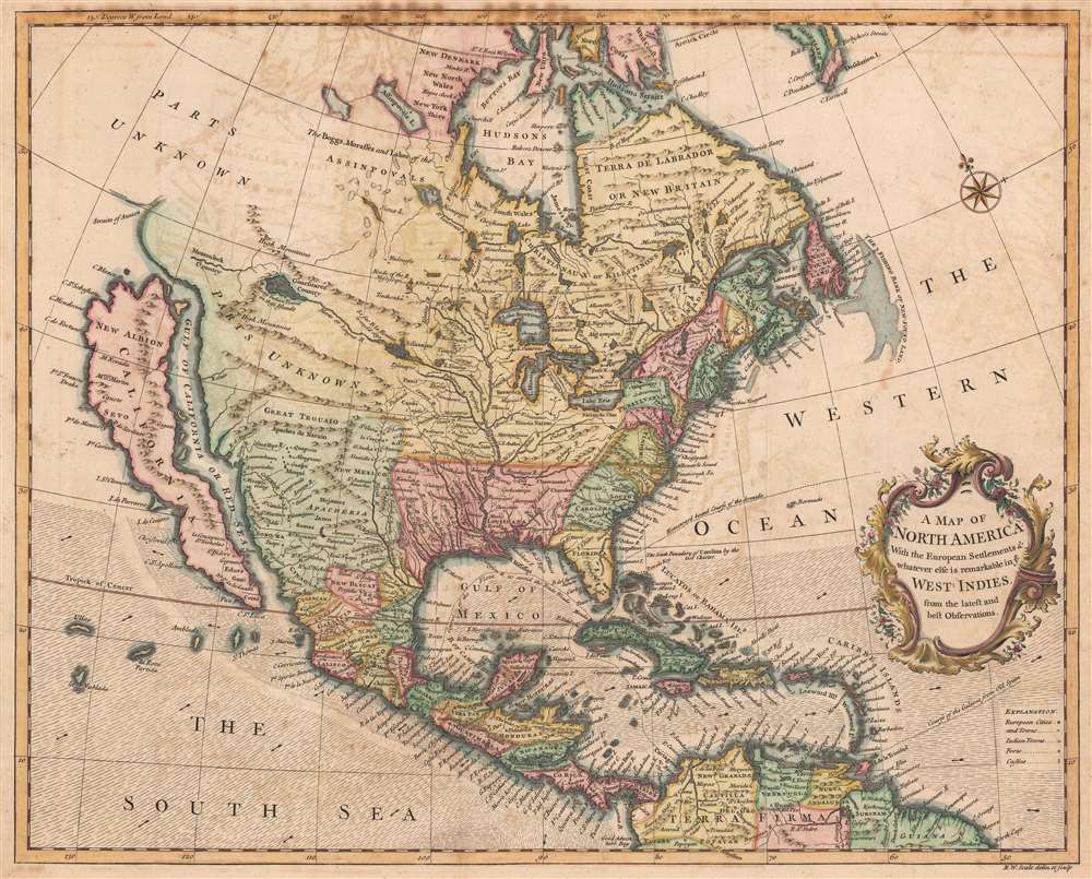
1745 Seale Map of North America w/Insular California
$1,950.00
1745 Seale Map of North America w/Insular California
NorthAmerica-seale-1745-2$550.00

Title
A Map of North America With the European Settlements and whatever else is remarkable in ye West Indies from the latest and best Observations.
1745 (undated) 15 x 18.5 in (38.1 x 46.99 cm) 1 : 20000000
1745 (undated) 15 x 18.5 in (38.1 x 46.99 cm) 1 : 20000000
Description
An uncommon 1745 by Richard W. Seale map of North America with California as an island. The map offers much of interest, including a fascinating mapping of the sources of the Mississippi River, California as an island, and the apocryphal geography of the Baron Lahontan.
Insular California here follows the 1635 Second Sanson model based upon the supposed discoveries of Luke Foxe in 1631-1632. Foxe never got close to California, but the map accompanying his 1635 narrative nonetheless introduced new cartography, particularly a modification of the northern part of Insular California that included several new bays identified as Talaago and R. de Estiete, as well as a peninsula from the mainland identified as Agubela de Cato. Foxe provides no basis for the new cartography, but it was embraced by Sanson in 1656 and had a lasting impact on subsequent mappings of Insular California, including that of Hendrick Doncker, Herman Moll, and, as here, Richard W. Seale. The present example is late in the history of mapping California in insular form and is one of the last maps to do so.
Lahontan was a French nobleman who was sent to America in 1683 with the Troupes de la Marine. After several failed military campaigns against English and Iroquois fortifications around the Great Lakes, Lahontan and his troops integrated with the local Algonquin Indians, living with them for several years. During this time, Lahontan embarked upon an expedition on a river he referred to as the Rivière Longue. Though many consider his tale fanciful, it may have some basis in truth. Lahontan claims to have followed the river for a reasonable distance to a mountain range. Beyond the mountains, he was told by his American Indian guides, lay another river that flows westward and has an outlet into a salt sea. There are many debates regarding this. Some consider it an early reference to the Missouri - Columbia River network later explored by Lewis and Clark, while others believe he may have stumbled upon an early description of the Great Salt Lake.
A Closer Look
Coverage embraces North America from Atlantic to Pacific, Baffin Bay to the Spanish Main, and Central America and the West Indies. Oceanic depths, winds, and currents are illustrated via stippling, shading, annotation, and arrows. A rococo title cartouche appears at right center.California as an Island
The idea of an insular California first appeared as a work of fiction in Garci Rodriguez de Montalvo's c. 1510 romance Las Sergas de Esplandian, where he writesKnow, that on the right hand of the Indies there is an island called California very close to the side of the Terrestrial Paradise; and it is peopled by black women, without any man among them, for they live in the manner of Amazons.Baja California was subsequently discovered in 1533 by Fortun Ximenez, who had been sent to the area by Hernan Cortez. When Cortez himself traveled to Baja, he must have had Montalvo's novel in mind, for he immediately claimed the 'Island of California' for the Spanish King. By the late 16th and early 17th century, ample evidence had been amassed, through explorations of the region by Francisco de Ulloa, Hernando de Alarcon, and others, that California was, in fact, a peninsula. However, by this time, other factors were in play. Francis Drake had sailed north and claimed 'New Albion' (identified here on the northwest coast of California Island) near modern-day Washington or Vancouver for England. The Spanish thus needed to promote Cortez's claim on the 'Island of California' to preempt English claims on the western coast of North America. The significant influence of the Spanish crown on European cartographers caused a major resurgence of the Insular California theory. Just before this map was made, Eusebio Kino, a Jesuit missionary, traveled overland from Mexico to California, conclusively proving the peninsularity of California.
Insular California here follows the 1635 Second Sanson model based upon the supposed discoveries of Luke Foxe in 1631-1632. Foxe never got close to California, but the map accompanying his 1635 narrative nonetheless introduced new cartography, particularly a modification of the northern part of Insular California that included several new bays identified as Talaago and R. de Estiete, as well as a peninsula from the mainland identified as Agubela de Cato. Foxe provides no basis for the new cartography, but it was embraced by Sanson in 1656 and had a lasting impact on subsequent mappings of Insular California, including that of Hendrick Doncker, Herman Moll, and, as here, Richard W. Seale. The present example is late in the history of mapping California in insular form and is one of the last maps to do so.
The Apocryphal Geography of the Baron Lahontan
This map is perhaps more interesting because of its embrace of the apocryphal geography of the Baron Louis-Armand de Lom d'Arce de Lahontan. Lahonan's geography here, including the Longue River, Gnacsitares country, and Mozemleck country, identifies the source of the Mississippi River as in a series of supposed lakes in the then-unexplored American northwest.Lahontan was a French nobleman who was sent to America in 1683 with the Troupes de la Marine. After several failed military campaigns against English and Iroquois fortifications around the Great Lakes, Lahontan and his troops integrated with the local Algonquin Indians, living with them for several years. During this time, Lahontan embarked upon an expedition on a river he referred to as the Rivière Longue. Though many consider his tale fanciful, it may have some basis in truth. Lahontan claims to have followed the river for a reasonable distance to a mountain range. Beyond the mountains, he was told by his American Indian guides, lay another river that flows westward and has an outlet into a salt sea. There are many debates regarding this. Some consider it an early reference to the Missouri - Columbia River network later explored by Lewis and Clark, while others believe he may have stumbled upon an early description of the Great Salt Lake.
Teguayo: A Kingdom of Gold
Great Teguaio (Teguayo) appears in the unmapped region to the west of Santa Fe. Teguayo was believed to be one of the Kingdoms of Gold presumed to be found in the unexplored American west. The name Teguayo first appears in the Benevides Memorial, where it is described as a kingdom of great wealth to rival Quivara, another mythical kingdom which curiously does not appear on this map. The idea was later popularized in Europe by the nefarious Spaniard and deposed governor of New Mexico, the Count of Penalosa. Penalosa, imagining himself a later day Pizzaro leading an army of conquest in the new world, promoted the Teguayo legend to the royalty of Europe. Originally Teguayo was said to lie west of the Mississippi and north of the Gulf of Mexico, but for some reason, the French cartographer D'Anville situated it further to the west - Seale here follows D'Anville's model.Publication History and Census
This map was included in the 1744/45 Tindal translation of Paul Rapin de Thoyras' French language Histoire d'Angleterre, published between 1724 and 1727. Tindal translated it into English in 1744, republishing the work, for the first time with maps, as Tindal's Continuation of Mr. Rapin's History of England. We note a dozen examples of the separate map cataloged in institutional collections worldwide.Cartographer
Richard William Seale (December 1703 - May 25, 1762) was an English a mapmaker and engraver active in London during the middle part of the 18th century. Seale was the son of Richard and Elizabeth Seale. Richard, his father, was a member of the Stationers Company, suggesting that printing and engraving must have been a family trade. Nonetheless, he did not learn the trade from his father, but rather from Samuel Parker of Clerkenwell, to whom he was apprenticed in 1719. Seale was extremely active as an engraver and publisher from about 1740 until his death in 1762. His cartographic corpus is vast; including pieces engraved for most other notable English cartographers of his period: Willdey, Baron, Toms, Rocque, Basire, Bowles, Benning, among others. In addition to cartographic work, Seale also produce numerous architectural engravings. More by this mapmaker...
Source
Rapin de Thoyras, M., The History of England, trans by N. Tindal, (London) 1745.
Condition
Very good. Transference. Verso repair to a fold separation.
References
McLaughlin, G., The Mapping of California as an Island: An Illustrated Checklist, 228. OCLC 785838378.