This item has been sold, but you can get on the Waitlist to be notified if another example becomes available, or purchase a digital scan.
1845 Tanner Map of North Carolina
NorthCarolina-tanner-1845$175.00

Title
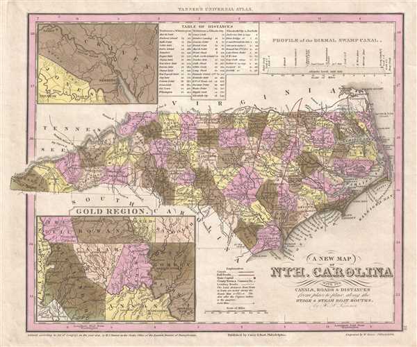
A New Map of Nth. Carolina with its Canals, Roads and Distances from place to place, along the Stage and Steam Boat Routes.
1845 (dated 1841) 11.5 x 14 in (29.21 x 35.56 cm) 1 : 2500000
1845 (dated 1841) 11.5 x 14 in (29.21 x 35.56 cm) 1 : 2500000
Description
This is an 1845 Henry Schenck Tanner map North Carolina published by Edward L. Carey and Abraham Hart. The map depicts the region from Tennessee, North Carolina, and South Carolina to Cape Hatteras and from Virginia to South Carolina. Featuring an inset map of the Carolina Gold Region in the lower left corner, this map propagates the longstanding American desire to strike it rich.
The Carolina Gold Rush
The first 'find' of the Carolina Gold Rush was made in 1799, by a 12-year-old boy name Conrad Reed. He found a 17-pound gold nugget while playing in Meadow Creek on his family's farm in Cabarrus County (depicted at the center of the inset map). As his father, John Reed, was unfamiliar with his son's find and what it was worth, the nugget spent the next several years as the family's door stop. In 1802, when Reed showed the rock to the local jeweler, the jeweler, who instantly recognized it as gold, offered Reed $3.50 for it. Still unaware of the rock's value, Reed agreed to the jeweler's offer. Eventually Reed learned of the value of the resource on his land and set up a partnership with several other men. As news of the discovery spread locally through newspapers, local landowners began searching for gold on their own land, since most of the land in the area was owned privately, establishing shallow surface mines on their property. By the 1830s, most of these surface deposits had been depleted, thus mining operations had been replaced by much more technical lode mining. With this development came a wave of immigrants from the Cornwall region of England. The people of Cornwall had been miners for decades, but the copper and tin deposits of the region had become exhausted. When word of the bonanza going on in North Carolina reached Cornwall, many miners immigrated to the region and brought their expertise with them. They built mines and taught the local Carolina miners their trade, which, in turn, helped drive the success of the much larger gold rush in California in 1849.
A Closer Look at the Map
A highly detailed map, counties are labeled throughout the state and shaded different colors to allow for easy differentiation. Myriad towns and cities are labeled, including Raleigh, Chapel Hill, New Bern (Newbern), Charlotte, Wilmington, and Asheville. A detailed depiction of the road network is illustrated as well, with the distances between cities and towns noted. Pamlico Sound and Albemarle Sound are both labeled, along with Roanoke Island and several locations in the Outer Banks.
An inset map of the region around New Bern (Newbern), North Carolina is situated in the upper-left corner and labels the Neuse River, the Trent River, the town of Trenton, and Fort Barnwell. At the time, New Bern was the largest city in North Carolina and played a critical role in the Triangle Trade in sugar, slaves, and desired goods. A table of distances between New Bern and Wilmington, Elizabeth City, and Norfolk, Virginia is located next to the inset map. A profile view of the Dismal Swamp Canal is situated in the upper right corner. The Dismal Swamp Canal was the longest continuously operating manmade canal in the United States, opening in 1805 and, after repairs due to storm damage in 2016, reopened in November 2017, only to be closed again.
This map was published in the 1845 edition of Carey and Hart's publication of Tanner's A New Universal Atlas.
CartographerS
Henry Schenck Tanner (1786 - May 18, 1858) was one of the preeminent American map engravers and publishers of the early 19th century - what is considered to be the "Golden Age of American Map Publishing". Born in New York City but based in Philadelphia, Tanner's forty plus year career was almost entirely focused on cartographic work. His earliest map work appears in conjunction with another important map publisher, John Melish. Early in his career, Tanner partnered with his brother Benjamin, to engrave extensively for Melish as well as other Philadelphia publishers including Lucas Fielding (Baltimore), A. Bourne, Jason Torey, Samuel Harrison, and Samuel Lewis, among others. In 1818 Tanner convinced his fellow publishers and partners to finance the compilation of a New American Atlas. The atlas was sold by subscription and slowly emerged between 1819 and 1823. The New American Atlas, possibly the pinnacle of 19th century American cartography and was commended in its day as "one of the most splendid works of the kind ever executed in this country". It was subsequently republished in several updated editions until about 1839. Tanner had by this time become the most active and influential map publisher in the United States. Around 1832, recognizing the market for a less cost prohibitive atlas, Tanner began work on the smaller format New Universal Atlas. This popular and important atlas went through numerous editions before being bought out by Carey and Hart, and then, in 1846, by S. A. Mitchell, who would rise to become the preeminent publisher of the next generation. In addition to these important atlases, Tanner also issued numerous extremely important and influential travelers guides, state maps, wall maps, and pocket maps. He should not be confused with his brother, also an America map engraver, the New Yorker Benjamin Tanner. More by this mapmaker...
Edward L. Carey (April 7, 1805 - June 16, 1845) was an American publisher, aesthete, art lover, and the co-founder, along with Abraham Hart, of the prominent publishing firm Carey and Hart. Carey was the son of American publisher Mathew Carey (1760 - 1839) and Bridget Flahaven Carey. He initially worked for his brother, Henry Charles Carey who, along with relative and partner Isaac Lea, purchased their father's publishing house in 1822, rebranding it as Carey and Lea. Eventually, Edward Carey became a junior partner in the firm, acquiring half of the shares belonging to Lea, and the imprint briefly changed to Carey, Lea, and Carey. On November 1, 1829, Edward Carey detached himself from his brother's firm and formed a partnership with Abraham Hart (1810 - 1885), an employee of Carey, Hart, and Carey. This firm, known as Carey and Hart, was successful for twenty-five years, publishing works by Henry Wadsworth Longfellow, William Cullen Bryant, and Eliza Leslie. Carey suffered from declining health during the last three years of his life. According to William Gilmore Sims, Carey died 'after suffering for some years from a tedious affliction of the spine.' Carey died on June 16, 1845 at the age of 40. Before his death, he was elected President of the Academy of Fine Arts, but declined the position due to his health. Learn More...
Abraham Hart (December 15, 1810 - July 22, 1885) was an American publisher of Jewish-Dutch descent based in Philadelphia. As a boy, Hart became an employee of the publishing firm Carey, Lea, and Carey. In 1829, when Edward Carey (1805 - 1845) left his older brother Mathew Carey's firm, Edward and Hart joined forces, forming Carey and Hart. This firm became very well-known and was successful for twenty-five years, publishing works by Henry Wadsworth Longfellow, William Cullen Bryant, and Eliza Leslie. Hart married Rebecca Cohen Isaacks in 1831. Carey died at the age of 40 in 1845, but Hart continued the publishing firm until he retired in 1854, which marked the end of the Carey and Hart imprint. After retiring, Hart involved himself with industrial enterprises, and served both the Centennial Button-hole Machine Company and the American Button-hole Machine Company in an executive capacity. Hart was also an active member of the Jewish community in Philadelphia, serving for a time as president of the Jewish Congregation Mickvéh Israel, and assisting in Jewish educational and charitable enterprises. Learn More...
Source
Tanner, H.S., A New Universal Atlas Contaning Maps of the various Empires, Kingdoms, States and Republics of the World. With a special map of each of the United States, Plans of Cities etc. Comprehended in seventy sheets and forming a series of One Hunderd and Seventeen Maps Plans and Sections (Philadelphia: Carey and Hart) 1844.
A New Universal Atlas was, for close to twenty-five years in the mid-nineteenth century, the predominant American atlas and formed the foundation of one of the longest running atlas editions in American history, published from at least 1836 until at least 1859. Henry S. Tanner published editions of A New Universal Atlas in 1836, 1839, and 1842, when the plates were acquired by the firm Carey and Hart. Carey and Hart published editions of the atlas from 1843 through 1845, when Samuel Augustus Mitchell bought the plates from Carey and Hart. Mitchell published editions under the imprint Mitchell's Universal Atlas from 1846 until 1849, when he sold the copyright to Thomas, Cowperthwait and Company, which published the atlas from 1850 until 1854. The 1855 edition of the atlas was published by Cowperthwait, DeSilver and Butler, and then by Charles DeSilver from 1855 until at least 1858. Cushing and Bailey published the last editions of the atlas from 1858 until at least 1859.
Condition
Very good. Even overall toning. Blank on verso.
References
Rumsey 5363.019.