1595 First Edition Mercator Map of the Arctic (1st Map of the North Pole)
NorthPole-mercator-1595$30,000.00

Title
Septentrionalium Terrarum descriptio.
1595 (undated) 15 x 16 in (38.1 x 40.64 cm) 1 : 40000000
1595 (undated) 15 x 16 in (38.1 x 40.64 cm) 1 : 40000000
Description
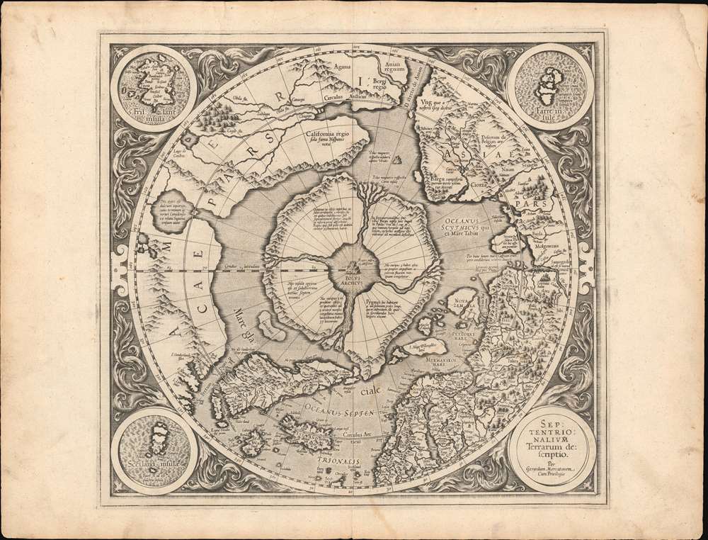
This is the first edition, first state of Gerard Mercator's seminal 1595 map of the Arctic, the great cartographer's most interesting and important atlas map. In this first edition, it is the scarcest of Mercator's atlas maps and a holy grail for any Arctic collector. For all its flaws and inaccuracies, it is a schematized interpretation of factual voyages between Norway, England, Iceland, Greenland, and Labrador (Markland).
In the fourteenth century, at the court of King Håkan Magnusson (1340 - 1380) in Norway, Cnoyen met and interviewed eight travelers from northern regions. One, a priest, even carried an astrolabe. Historian E. G. Taylor ('A letter dated 1577 from Mercator to John Dee.' Imago Mundi 13:56–68) believed Cnoyen's voyagers were Norse settlers from 'Greenland, or even . . . a group from Markland (Labrador).' The combination of concrete voyager's reports with the tantalizing, remote voyages of a legendary king helped cement Mercator's formulation of the Arctic as he presented here.
Lake Conibas, the attached bay and its rivers first appeared on the 1575 André Thevet map of America. (The system also appears, in slightly different form, on the 1593 De Jode Americae Pars Borealis.) To include it here, Mercator bisected his 'Bergi regio,' moving that placename to the south. In doing so, he created a new peninsula north of the Arctic Circle, and it is this to which he applied the California text. (It appears unlikely that even the Spanish knew about this region, since it was probably entirely the creation of Mercator.)
On the other hand, Conibaz and its attendant rivers represent an important passage of explorers' information to Mercator. Thevet is known to have met with Jacques Cartier (1491 - 1557), who explored the Saint Lawrence River and interacted with the Iroquoians. The term Conibaz may relate to 'Cornibotz' (Wampum shells). Cartier's report via Thevet appears to have been informed by his conversations with the Iroquois, and this reflects factual indigenous reports of the North American interior. Conibaz has been associated by some scholars with Great Salt Lake, Lake Ontario, or even the Great Lakes in general. Thus Mercator, and other cartographers had general knowledge of great inland lakes of North America long before Europeans actually encountered them.
Still, Mercator's application of the term 'California' to a region north of the Arctic circle is baffling. The 1595 America uses the word only to refer to the tip of the Baja Peninsula; it does not appear prominently in his 1569 world map. (Ortelius's 1570 America would apply the name to the tip of Baja; his edited 1587 America used the term for the entire peninsula.) No other map of which we are aware uses the term as it appears here. The 1593 De Jode, although it includes Thevet's bay and Lake Conibaz, more appropriately places California to the south. It may be that Mercator was simply referring to the whole of Spain's discoveries on the West Coast as 'California,' and including the Arctic regions among them, but why then did he not do so in any other map?
Context of this Polar Projection
Mercator's Arctic projection has its roots in a magnificent 1569 wall map of the world in which Mercator first introduces his revolutionary projection. The difficulty with the Mercator Projection is that it dramatically inflates the appearance of size it draws near to the poles: its application to the polar regions themselves would result in an infinitely tall map. Mercator therefore included a polar projection, very similar to the map shown here, in the lower-left corner of his wall map. Mercator produced the present map, expanded and updated from his wall map, for inclusion in the first edition of his Atlas, published posthumously in 1595. As such, it is the first specific separate map of the Arctic.Taking it from the Top
At the North Pole, Mercator depicts a large black rock, the Rupes Nigra, surrounded by a great whirlpool fed by four powerful rivers - 'the Indrawing Seas'. These divide a massive continent-sized landmass into four distinct islands. When the English polymath John Dee wrote to Mercator asking about his sources for this map, Mercator returned the following letter which survives in his own hand (April 20, 1577, British Library):In the midst of the four countries is a Whirl-pool, into which there empty these four indrawing Seas which divide the North. And the water rushes round and descends into the Earth just as if one were pouring it through a filter funnel. It is four degrees wide on every side of the Pole, that is to say eight degrees altogether. Except that right under the Pole there lies a bare Rock in the midst of the Sea. Its circumference is almost 33 French miles, and it is all of magnetic Stone (…) This is word for word everything that I copied out of this author years ago.The author to which Mercator referred is the Dutch traveler Jacobus Cnoyen van Tsertoghenbosche, whose report combined firsthand encounters with interpretations of an enigmatic lost work, the Inventio Fortunata (Fortunate Discoveries). This 14th century work, now largely forgotten, was a well-known resource for cartographers of the 15th and 16th centuries. The mysterious author may have been Nicholas of Lynn, Thomas Kingsbury, or Hugh of Ireland. The work told of a Minorite monk from Oxford who traveled extensively in northern lands, including Iceland, Greenland, Norway, and possibly even Labrador. The Inventio also cited far older lost works, the Principio Gestorum Arturi and the Leges Anglorum Londoniis Collectae, which contributed a chapter to the legend of King Arthur, casting him as a 6th century Arctic explorer, and describing Arthurian conquests of Iceland, Greenland, the Faeroes, parts of Norway, and even the North Pole.
King Arthur - Arctic Explorer
The Inventio described Arthur's invading Arctic army as consisting of some 4000 men on 12 ships. He sent the army into one of these 'indrawing seas', apparently the only way to bypass the 'Encircling Arctic Mountains'. According to John Dee, in Arthur's time there were cities lying beyond those mountains. Perhaps unsurprisingly, no further report of this momentous invasion appears in Arthurian record.In the fourteenth century, at the court of King Håkan Magnusson (1340 - 1380) in Norway, Cnoyen met and interviewed eight travelers from northern regions. One, a priest, even carried an astrolabe. Historian E. G. Taylor ('A letter dated 1577 from Mercator to John Dee.' Imago Mundi 13:56–68) believed Cnoyen's voyagers were Norse settlers from 'Greenland, or even . . . a group from Markland (Labrador).' The combination of concrete voyager's reports with the tantalizing, remote voyages of a legendary king helped cement Mercator's formulation of the Arctic as he presented here.
The Magnetic North
The black rock at the pole, the Rupes Nigra, also came to Mercator from Cnoyen, who reported that it was made of magnetic stone (an explanation the wonders of the compass). Mercator, however, did not ascribe to Rupes Negra the magnetic properties claimed by Cnoyen. Instead, Mercator placed a different magnetic rock to the north of the Strait of Anian, and it was this that he identified as the magnetic pole: an attempt to explain the correct observation that the geographic pole and the magnetic pole were not the same.Perilous Waters
The placement, both by medieval scholars and Mercator, of violent currents and whirlpools in the northern waters was neither isolated nor fanciful. The Lofoten Maelstrom on the coast of Norway inspired many early legends, for example. The explorers John Davis and Martin Frobisher both believed the strong currents that they encountered corresponded to Mercator's polar rivers and their descriptions reflected such:This place seemeth to have a marvellous great indrafte, and draweth in to it most of the drift ice and other things which doe flote in the sea (George Best - Martin Frobisher's Lieutenant)It is hard to know exactly what these navigators witnessed, but there can be no doubt that Arctic currents in Davis's Strait are powerful and erratic. Mercator was not in doubt: at the southern opening of Davis Strait, he noted in English, 'a furious over fall.'
which inlet or gulfe this afternoone and in the night we passed over: where to our great admiration we saw the sea falling down into the gulfe with a mighty overfal and roaring, and with divers circular motions like whirle-pooles. (James Davis)
Indigenous Peoples
Throughout the map are references to remote Indigenous populations. These include the Samoyed people of Siberia (described here as cannibals), and the Zolotaya Baba or 'Golden Woman,' an idol worshipped by indigenes on the Ob River. This probably derives from Sigismund von Herberstein's (1486 - 1566) 1557 map of Muscovy which included the idol. Ir is very likely that Herberstein's book informed Mercator's geography for Siberia, as did the small map of Maciej Miechowita (1457 - 1523). Further north, the Latin text on the island north of Norway notes 'Here live pygmies, at most 4 feet tall, who are like those in Greenland called Scraelings.' This may derive again from Cnoyen, but from his report of Norse travelers: the name 'Scraeling,' referring to the Inuit of Greenland, was a Viking term. It also appeared in the Sagas referring to abortive Viking efforts to colonize Vinland. Placing the Inuit on that particular Arctic island, neighboring Greenland, would be a reasonable assumption; after all, Mercator notes the presence of Scraelings in Greenland as well.Zeno anf Frisland
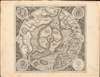
The difficulty Mercator confronted in presenting a map of such remote regions is not just that the sources available to him were few, but that they could not be confirmed - resulting in the perpetuation of geographical information that was arguably concocted deceptively. Hence, his inclusion of the imaginary island of Frisland, which appears between Greenland and Iceland. Mercator's delineation of this region is drawn from the 1558 map of Nicolo Zeno the younger, informed by the purported explorations of his ancestors Nicolo and Antonio Zeno. The brothers Zeno allegedly explored the coasts of Greenland and Labrador in the 14th century, and as such were held forth as a Venetian discovery of America. Modern historical consensus has been that Nicolo the Younger's map was a hoax, with a minority of dissenters considering it a confused re-telling of a legitimate voyage. Some archival evidence places the Zeno brothers in Venice at the time they were supposedly at sea; it is possible that they never voyaged at all. Nevertheless, in the 16th century Zeno's map was accepted as legitimate. Warts and all, it represented the first attempt at mapping the remote north Atlantic, and so its many phantom islands - notably Frisland - would be included on the maps of Mercator and other cartographers well into the 17th century. Mercator thought Frisland important enough that he assigned one of three detail maps to it: the other two roundels portray the Shetland Islands and the Faroe Islands, respectively. (Iceland was afforded a full map to itself, so it is no outrage that it was not shown in greater detail here.)Drawing on Thevet and Cartier
Mercator's mapping of North America is unique among his works. It features the 'Lago de Conibaz', a large lake with a central island and a river emptying far to the west into a great bay north of the Strait of Anian. The land directly south of the bay is named 'Bergi Regio,' while that to the north bears an astonishing Latin text reading (in translation), 'California region, known only to the Spanish.' This system bears no similarity to any other Mercator map of which we are aware. Mercator's 1569 world map obscured this whole area under a cartouche; its Arctic inset lacks Conibaz and its attached bay. Likewise, neither his 1595 America sive India Nova nor his son Rumold's 1587 world map include them. In all of these other maps, the whole region north of Anian Regnum was collectively referred to as Bergi regio, and the California reference appearing here is repeated nowhere else.Lake Conibas, the attached bay and its rivers first appeared on the 1575 André Thevet map of America. (The system also appears, in slightly different form, on the 1593 De Jode Americae Pars Borealis.) To include it here, Mercator bisected his 'Bergi regio,' moving that placename to the south. In doing so, he created a new peninsula north of the Arctic Circle, and it is this to which he applied the California text. (It appears unlikely that even the Spanish knew about this region, since it was probably entirely the creation of Mercator.)
On the other hand, Conibaz and its attendant rivers represent an important passage of explorers' information to Mercator. Thevet is known to have met with Jacques Cartier (1491 - 1557), who explored the Saint Lawrence River and interacted with the Iroquoians. The term Conibaz may relate to 'Cornibotz' (Wampum shells). Cartier's report via Thevet appears to have been informed by his conversations with the Iroquois, and this reflects factual indigenous reports of the North American interior. Conibaz has been associated by some scholars with Great Salt Lake, Lake Ontario, or even the Great Lakes in general. Thus Mercator, and other cartographers had general knowledge of great inland lakes of North America long before Europeans actually encountered them.
Still, Mercator's application of the term 'California' to a region north of the Arctic circle is baffling. The 1595 America uses the word only to refer to the tip of the Baja Peninsula; it does not appear prominently in his 1569 world map. (Ortelius's 1570 America would apply the name to the tip of Baja; his edited 1587 America used the term for the entire peninsula.) No other map of which we are aware uses the term as it appears here. The 1593 De Jode, although it includes Thevet's bay and Lake Conibaz, more appropriately places California to the south. It may be that Mercator was simply referring to the whole of Spain's discoveries on the West Coast as 'California,' and including the Arctic regions among them, but why then did he not do so in any other map?
Revelations in Central Asia
Opposite the American side of the Strait of Anian, is the Asian land of Gog, which appears bound in a tight ring of mountains. Gog and Magog, Biblical nations from the Book of Revelations, were associated by many Europeans with the Tartars. It was believed that Alexander the Great walled off the Kingdom of Gog and Magog behind a mountain range. Many early maps, following up on this legend as well as references from the journals of Marco Polo, place either Gog or Magog in the northeastern extreme of Asia behind an impenetrable mountain range.Publication History and Census
This first state of Mercator's Arctic map was introduced in the 1595 first edition of Mercator's Atlas sive cosmographicae… It bears the elder Mercator's imprint, and is attributed to him. (We note that the composition of this map, with its circular cartouche and insets, and acanthus borders, is reminiscent of the 1595 America sive India Nova, which was engraved by Mercator's grandson Michael.) Jodocus Hondius, having acquired the Atlas in 1606, significantly altered and updated the plate. Examples of the Mercator/ Hondius second plate remained in the atlas until 1634, and various editions of that version of the map appear on the market from time to time. This 1595 first state is virtually unobtainable.CartographerS
Gerard Mercator (March 5, 1512 - December 2, 1594) is a seminal figure in the history of cartography. Mercator was born near Antwerp as Gerard de Cremere in Rupelmonde. He studied Latin, mathematics, and religion in Rupelmonde before his Uncle, Gisbert, a priest, arranged for him to be sent to Hertogenbosch to study under the Brothers of the Common Life. There he was taught by the celebrated Dutch humanist Georgius Macropedius (Joris van Lanckvelt; April 1487 - July 1558). It was there that he changed him name, adapting the Latin term for 'Merchant', that is 'Mercator'. He went on to study at the University of Louvain. After some time, he left Louvain to travel extensively, but returned in 1534 to study mathematics under Gemma Frisius (1508 - 1555). He produced his first world map in 1538 - notable as being the first to represent North America stretching from the Arctic to the southern polar regions. This impressive work earned him the patronage of the Emperor Charles V, for whom along with Van der Heyden and Gemma Frisius, he constructed a terrestrial globe. He then produced an important 1541 globe - the first to offer rhumb lines. Despite growing fame and imperial patronage, Mercator was accused of heresy and in 1552. His accusations were partially due to his Protestant faith, and partly due to his travels, which aroused suspicion. After being released from prison with the support of the University of Louvain, he resumed his cartographic work. It was during this period that he became a close fried to English polymath John Dee (1527 - 1609), who arrived in Louvain in 1548, and with whom Mercator maintained a lifelong correspondence. In 1552, Mercator set himself up as a cartographer in Duisburg and began work on his revised edition of Ptolemy's Geographia. He also taught mathematics in Duisburg from 1559 to 1562. In 1564, he became the Court Cosmographer to Duke Wilhelm of Cleve. During this period, he began to perfect the novel projection for which he is best remembered. The 'Mercator Projection' was first used in 1569 for a massive world map on 18 sheets. On May 5, 1590 Mercator had a stroke which left him paralyzed on his left side. He slowly recovered but suffered frustration at his inability to continue making maps. By 1592, he recovered enough that he was able to work again but by that time he was losing his vision. He had a second stroke near the end of 1593, after which he briefly lost speech. He recovered some power of speech before a third stroke marked his end. Following Mercator's death his descendants, particularly his youngest son Rumold (1541 - December 31, 1599) completed many of his maps and in 1595, published his Atlas. Nonetheless, lacking their father's drive and genius, the firm but languished under heavy competition from Abraham Ortelius. It was not until Mercator's plates were purchased and republished (Mercator / Hondius) by Henricus Hondius II (1597 - 1651) and Jan Jansson (1588 - 1664) that his position as the preeminent cartographer of the age was re-established. More by this mapmaker...
Jodocus Hondius (October, 14 1563 - February 12, 1612) was an important Dutch cartographer active in the late 16th and early 17th centuries. His common name, Jodocus Hondius is actually a Latinized version of his Dutch name, Joost de Hondt. He is also sometimes referred to as Jodocus Hondius the Elder to distinguish him from his sons. Hondius was a Flemish artist, engraver, and cartographer. He is best known for his early maps of the New World and Europe, for re-establishing the reputation of the work of Gerard Mercator, and for his portraits of Francis Drake. Hondius was born and raised in Ghent. In his early years he established himself as an engraver, instrument maker and globe maker. In 1584 he moved to London to escape religious difficulties in Flanders. During his stay in England, Hondius was instrumental in publicizing the work of Francis Drake, who had made a circumnavigation of the world in the late 1570s. In particular, in 1589 Hondius produced a now famous map of the cove of New Albion, where Drake briefly established a settlement on the west coast of North America. Hondius' map was based on journal and eyewitness accounts of the trip and has long fueled speculation about the precise location of Drake's landing, which has not yet been firmly established by historians. Hondius is also thought to be the artist of several well-known portraits of Drake that are now in the National Portrait Gallery in London. In 1593, Hondius returned to Amsterdam, where he remained until the end of his life. In 1604, he purchased the plates of Gerard Mercator's Atlas from Mercator's grandson. Mercator's work had languished in comparison to the rival atlas, Theatrum Orbis Terrarum by Ortelius. Hondius republished Mercator's work with 36 additional maps, including several which he himself produced. Despite the addition of his own contributions, Hondius recognizing the prestige of Mercator's name, gave Mercator full credit as the author of the work, listing himself as the publisher. Hondius' new edition of Mercator revived the great cartographer's reputation and was a great success, selling out after a year. Hondius later published a second edition, as well as a pocket version called the Atlas Minor. The maps have since become known as the "Mercator/Hondius series". Between 1605 and 1610 Hondius was employed by John Speed to engrave the plates for Speed's The Theatre of the Empire of Great Britaine. Following Hondius' death in 1612, his publishing work in Amsterdam was continued by his widow and two sons, Jodocus II and Henricus. Later his family formed a partnership with Jan Jansson, whose name appears on the Atlasas co-publisher after 1633. Eventually, starting with the first 1606 edition in Latin, about 50 editions of the Atlas were released in the main European languages. In the Islamic world, the atlas was partially translated by the Turkish scholar Katip Çelebi. The series is sometimes called the 'Mercator/Hondius/Jansson' series because of Jansson's later contributions. Hondius' is also credited with a number of important cartographic innovations including the introduction of decorative map borders and contributions to the evolution of 17th century Dutch wall maps. The work of Hondius was essential to the establishment Amsterdam as the center of cartography in Europe in the 17th century. Learn More...
Source
Mercator, G., Atlantis Pars Altera, (Rumold Mercator) 1595.
Mercator's Atlas is one of the most important works in the history of cartography. Although in fact Ortelius was the first to publish a proper atlas, the Teatrum Orbis Terrarum, Mercator's work the first book to employ the term Atlas for a collection of maps. The term is derived both from the mythical titan, Atlas, who was forced to bear the world upon his shoulders, and the Libyan king, philosopher, and astronomer of the same name that, so the legend goes, constructed the first globe. Mercator dedicated the final 25 years of his life to compile the Atlas. He published two parts during his lifetime in 1585 and 1589, but the final part published posthumously by his son Rumold Mercator, in 1595. The map plates for the Atlas were later acquired by Jodocus Hondius who published the most complete and well known edition in 1606. It was Jodocus who popularized the Atlas and who did the most to elevate Gerard Mercator's name.
Condition
Very good. Generous margins. Minor corner reinstatement upper right - limited out outer margin.
References
OCLC 956283416. Rumsey 10805.001. Taylor, E.G.R. (1956). 'A Letter Dated 1577 from Mercator to John Dee', Imago Mundi 13: 56–68. Van der Krogt, P. C. J., Koeman's Atlantes Neerlandici, 0020:1A. Verner, Coolie and Stuart-Stubbs, B., The North Part of America, p. 142-187. National Library of Australia, 1628 MAP RM 150. Ginsberg, William B., Printed Maps of Scandinavia and the Arctic, 1482-1601, 33.3. Kershaw, K., Early Printed Maps of Canada, 23C. Costa, B. F., 'Arctic Exploration', Journal of the American Geographical Society of New York, Vol 12, p. 159-192. Pool, J., 'Spitsbergen: Early Exploration and Mapping', IMCOS Journal, vol 121, 35-42. Burden, P., The Mapping of North America, #88. Shirley, Rodney W., The Mapping of the World: Early Printed World Maps 1472-1700, #119. Van Duzer, C., 'The Mythic Geography of the Northern Polar Regions: Inventio fortunata and Buddhist Cosmology', Culturas Populares, Revista Electronica 2 (2006). Brooke-Hitching, E., The Phantom Atlas: The Greatest Myths, Lies and Blunders on Maps (London: Simon and Schuster, 2016). Ruggles, R. I., 'The Cartographic Lure of the Northwest Passage: Its Real and Imaginary Geography,' in Meta Incognita: A Discourse of Discovery; Martin Frobisher’s Arctic Expeditions, 1576-1578, edited by Thomas H. B. Symons (Hull, Quebec: Canadian Museum of Civilization, 1999), vol. I, 179-256.