Digital Image: 1820 David Smith and Franz Pluth Map of Ontario, Canada
OberCanada-pluth-1820_d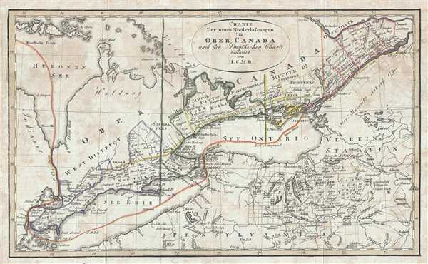

Title
Charte Der neuen Niederlassungen in Ober Canada nach der Smythchen Charte reducirt von I.C.M.R.
1820 (undated) 7.5 x 12.5 in (19.05 x 31.75 cm) 1 : 2600000
1820 (undated) 7.5 x 12.5 in (19.05 x 31.75 cm) 1 : 2600000
Description
FOR THE ORIGINAL ANTIQUE MAP, WITH HISTORICAL ANALYSIS, CLICK HERE.
Digital Map Information
Geographicus maintains an archive of high-resolution rare map scans. We scan our maps at 300 DPI or higher, with newer images being 600 DPI, (either TIFF or JPEG, depending on when the scan was done) which is most cases in suitable for enlargement and printing.
Delivery
Once you purchase our digital scan service, you will receive a download link via email - usually within seconds. Digital orders are delivered as ZIP files, an industry standard file compression protocol that any computer should be able to unpack. Some of our files are very large, and can take some time to download. Most files are saved into your computer's 'Downloads' folder. All delivery is electronic. No physical product is shipped.
Credit and Scope of Use
You can use your digial image any way you want! Our digital images are unrestricted by copyright and can be used, modified, and published freely. The textual description that accompanies the original antique map is not included in the sale of digital images and remains protected by copyright. That said, we put significant care and effort into scanning and editing these maps, and we’d appreciate a credit when possible. Should you wish to credit us, please use the following credit line:
Courtesy of Geographicus Rare Antique Maps (https://www.geographicus.com).
How Large Can I Print?
In general, at 300 DPI, you should at least be able to double the size of the actual image, more so with our 600 DPI images. So, if the original was 10 x 12 inches, you can print at 20 x 24 inches, without quality loss. If your display requirements can accommodate some loss in image quality, you can make it even larger. That being said, no quality of scan will allow you to blow up at 10 x 12 inch map to wall size without significant quality loss. For more information, it is best consult a printer or reprographics specialist.
Refunds
If the high resolution image you ordered is unavailable, we will fully refund your purchase. Otherwise, digital images scans are a service, not a tangible product, and cannot be returned or refunded once the download link is used.
Cartographer S
Sir David William Smith (Smyth) (September 4, 1764 - May 9, 1837) was a British army officer, surveyor, public servant, and politician. Born in Salisbury, England to parents John Smith, a career soldier, and Anne Waylen. Smith was commissioned as an ensign in the 5th Foot (later the Northumberland Regiment) in 1779. Following his marriage to Anne O’Reilly in 1788, Smith rejoined the regiment at its post in Detroit in 1790, when the regiment was under the command of his father. Due to his efficiency on the Hesse land board and because he thought the 5th the best-administered regiment in the newly-created province of Upper Canada, Lieutenant Governor John Graves Simcoe made Smith the unauthorized offer of the post of acting deputy surveyor general for the province. The Secretary of State, Henry Dundas, believed that the job could be handled by the three assistant surveyors employed at the time and that they could be directed by the surveyor general at Quebec, thus Smith’s unclear status. Smith accepted, even though the job would be without salary or fees until Smith was confirmed as Surveyor General of Upper Canada on January 1, 1798. Upon receiving this confirmation, Smith immediately resigned from the army. At that point Smith received back salary not only to September 28, 1792, the date of his commission from Simcoe, but also from July 1, 1792, when his service actually began. Smith served as Surveyor General of Upper Canada from 1792 until he left in July 1802. Smith used his position as surveyor to accrue more than 20,000 acres in 21 townships, believed to be some of the best land in the province. He also served as a member of the House of Assembly from August 27 1792 until his departure from Upper Canada, having been elected three times. Even though Smith was a valued member of the administration of Upper Canada (one official was quoted as saying 'Six months of [Smith's] labor is of greater benefit to the Province than as many years of many others), he was denied his request in 1804 to return to the province and become a member of the Legislative Council, due to his unpopularity among some of the large landowners. Upon this refusal, and the fact that he had remarried while in England, Smith gave notice that he was resigning all of his Upper Canadian appointments, the command of the militia, and a list two pages long of minor offices and commissions. Smith issued A short topographical description of his majesty's province of Upper Canada, in North America; to which is annexed a provincial gazetteer in 1799 to accompany A Map of the province of Upper Canada, describing all the new settlements…from Quebec to Lake Huron, which he compiled. The description was reissued with a new map in 1813. More by this mapmaker...
Franz Pluth (1800 - 1871) was an engraver based in Prague, the capital of the Kingdom of Bohemia, then part of the Habsburg Austrian Empire. Pluth was born in Prague and most likely died in Zbraslav. He was active as a map engraver until at least 1848. His work is similar in style to that of Karl Ferdinand Weiland, a prolific German engraver, with whom he may have worked. Learn More...
Source
Linder, F. L., Neueste Länder - und Völkerkunde, ein geographisches Lesebuch für alle Stände. , (Prague) 1820.
Linder's book is typically dated 1820, but contains maps dated between 1816 and 1825.
References
OCLC 163166140.