This item has been sold, but you can get on the Waitlist to be notified if another example becomes available, or purchase a digital scan.
1752 Vaugondy Map of the Ancient World in Hemispheres
OrbisVetus-vaugondy-1757$500.00

Title
Orbis Vetus in utraque continente juxta mentem Sansonianam distinctus, nec non observationibus astonimicis redactus.
1752 (dated) 20 x 28.5 in (50.8 x 72.39 cm) 1 : 70000000
1752 (dated) 20 x 28.5 in (50.8 x 72.39 cm) 1 : 70000000
Description
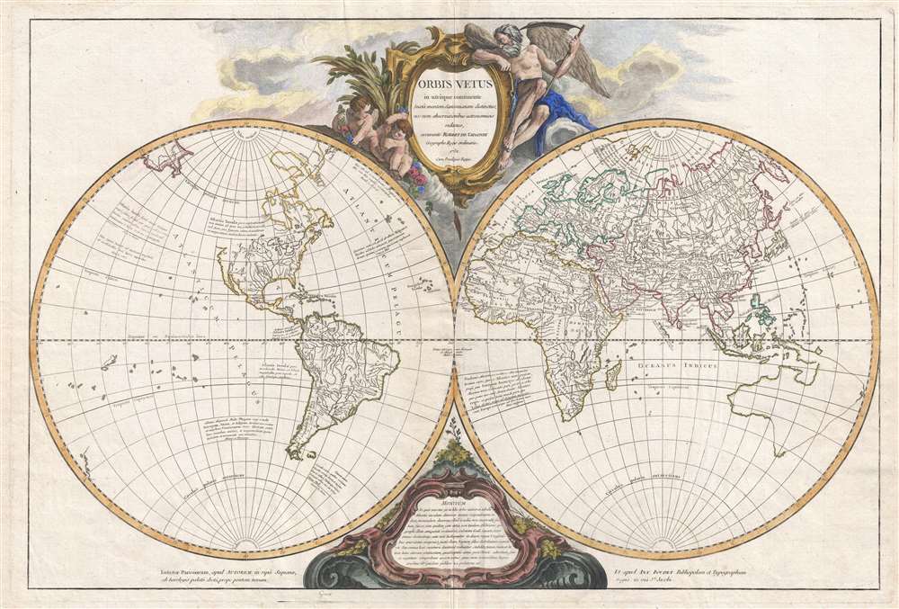
This is a striking and impressive 1752 map of the world as known by the Ancients by Gilles Robert de Vaugondy. The map depicts the entire world embraced in two hemispherical projections separated by the Vaugondy firm's distinctive bold cartouche work. This map is a curious work following somewhat on Sanson in that it attempts to express the New World (Americas) within the context of Hellenic tradition. All of the place names in the New World are drawn from ancient Greek mythology with Latin quotations by Plato (Critias and Timaeus), Lucius Annaeus Seneca (Medea, et al), Theopompus, and Claudius Aelianus annotating the Western Hemisphere. The New World itself is identified as 'Atlantis Insula' referring to the lost island civilization first brought to light in Plato's Critias and Timaeus.
Vaugondy identifies two cities in the Americas, Machimo or Bellatrix, which is situated on the site of modern-day Mexico City or Aztec Tenochtitlan, and Eusebes, located at the site the ancient Inca capital of Cusco, Peru. Machimos and Eusebes were, according to Theopompus, the two greatest cities of Hyperborea. Hyperborea itself was mythic sometimes utopic continent inhabited by giants, gods, centaurs, and other beasts of legend. The inhabitants of Machimos were warlike, dominated their neighbors, and rich in gold and other treasures - a not inaccurate descriptions of the Aztec Empire. However, Theopompus also suggests that they were also invulnerable to iron - alas if Vaugondy's placement of Machimos is to be believed history has proven otherwise. The Eusebes, on the other hand were a peaceful and pious people more commonly associated with the utopian Hyperborea. It is said that the Eusebes were free from all disease, though alas, if they were indeed the Inca, history again seems counter to legend.
Aside from the map's curious integration with mythic antiquity, the map is consistent with cartographic conventions of the period. The northwestern part of America is left blank and is fully unknown. South America features a large central lake, an unlabeled apocryphal Lago de Xarayes, at the northern terminus of the Paraguay River. Some of the rivers in Patagonia extend from the Atlantic through the Andes nearly to the shores of the Pacific - suggestive of hopeful dreams of an easy river transit through the continent. Central Africa follows on the Ptolemaic model, with the White Nile terminating in dual lakes at the foot of the Montes Luna (Mountains of the Moon). It is noteworthy that the at least one of these lakes is highly similar in form to Lake Malawi or Lake Tanganyika, though ostensibly these lakes had been neither seen nor heard of by Europeans until the mid-19th century. Australia is vaguely represented with a speculative ghosted eastern coastline that connecting it with Tanzania and New Guinea. New Zealand appears embryonically in the lower left quadrant, but is unlabeled. In the South Pacific, various island groups are presented based upon early Spanish expeditions, such as that of Quiros, but are highly speculative and inaccurate.
Elaborate allegorical cartouche work of a rococo ethic occupies the regions between the Hemispheres. The upper cartouche features the map's title surrounded by allegorical representations of Father Time as a winged bearded angel and two putti. The lower cartouche features a textual explanation of the map in Latin. All in all, a fascinating presentation and one of the highlights of Vaugondy and Boudet's impressive 1757 Atlas Universale.
Cartographer
Robert de Vaugondy (fl. c. 1716 - 1786) was French may publishing from run by brothers Gilles (1688 - 1766) and Didier (c. 1723 - 1786) Robert de Vaugondy. They were map publishers, engravers, and cartographers active in Paris during the mid-18th century. The father and son team were the inheritors to the important Nicolas Sanson (1600 - 1667) cartographic firm whose stock supplied much of their initial material. Graduating from Sanson's maps, Gilles, and more particularly Didier, began to produce their own substantial corpus. The Vaugondys were well-respected for the detail and accuracy of their maps, for which they capitalized on the resources of 18th-century Paris to compile the most accurate and fantasy-free maps possible. The Vaugondys compiled each map based on their own geographic knowledge, scholarly research, journals of contemporary explorers and missionaries, and direct astronomical observation. Moreover, unlike many cartographers of this period, they took pains to reference their sources. Nevertheless, even in 18th-century Paris, geographical knowledge was limited - especially regarding those unexplored portions of the world, including the poles, the Pacific Northwest of America, and the interiors of Africa, Australia, and South America. In these areas, the Vaugondys, like their rivals De L'Isle and Buache, must be considered speculative or positivist geographers. Speculative geography was a genre of mapmaking that evolved in Europe, particularly Paris, in the middle to late 18th century. Cartographers in this genre would fill in unknown lands with theories based on their knowledge of cartography, personal geographical theories, and often dubious primary source material gathered by explorers. This approach, which attempted to use the known to validate the unknown, naturally engendered rivalries. Vaugondy's feuds with other cartographers, most specifically Phillipe Buache, resulted in numerous conflicting papers presented before the Academie des Sciences, of which both were members. The era of speculative cartography effectively ended with the late 18th-century explorations of Captain Cook, Jean Francois de Galaup de La Perouse, and George Vancouver. After Didier died, his maps were acquired by Jean-Baptiste Fortin, who in 1787 sold them to Charles-François Delamarche (1740 - 1817). While Delamarche prospered from the Vaugondy maps, he defrauded Vaugondy's window Marie Louise Rosalie Dangy of her rightful inheritance and may even have killed her. More by this mapmaker...
Source
Robert de Vaugondy, G., Atlas Universel, (Paris: Antoine Boudet) 1752.
The Atlas Universel was the crowning glory of the Robert de Vaugondy firm's atlas production. The atlas was revolutionary on many levels and exemplified the Vaugondy credo commode, complet, univorme, et suive (convenient, complete, uniform, and easy to use). The atlas thus consisted of a wide corpus of maps, both modern and historical, was of moderate height and width, and featured maps of uniform style and structure. They partnered with Antoine Boudet, a shrewd businessman and publisher with whom they had worked previously, to produce the 1752 first edition. To minimize his fiscal risk, Boudet sold the atlas first by subscription using a large prospectus, receiving in the process over 1100 pre-orders. The first edition appeared in 1752 and contained beautifully produced maps with elaborate freshly designed allegorical cartouche work, generally by Pierre-Edme Babel, Pierre Philippe Choffard, and Charles Nicholas Cochin. Most of the maps were engraved by the Delahaye firm, the payment for whose services ultimately led to legal disputes. Despite proving a popular work of astounding quality, the Atlas Universal received harsh criticism from fellow cartographers, particularly Philipppe Buache. Ever at odds with the Vaugondys, Buache's critical perspective may have been influenced more by political maneuvering than academic affront. The atlas was issued in multiple editions between 1752 and 1788. Later editions, issued after 1786, were taken over by Charles Delamarche, who inherited the Robert de Vaugondy firm and assumed Boudet's publication rights.
Condition
Very good. Minor wear along original fold lines. Original platemarks visible. Minor spotting. Print crease across western hemisphere.
References
Rumsey, 3353.001. Pedley, Mary Sponberg Belle et Utile: The Work of the Robert de Vaugondy Family of Mapmakers, 13. Fordham, Studies in Cartobibligraphy p. 165.