Digital Image: 1882 Emrick and Binger View of First Rate Ship of the Line, Royal Navy
OurBritishNavy-emrikbinger-1882_d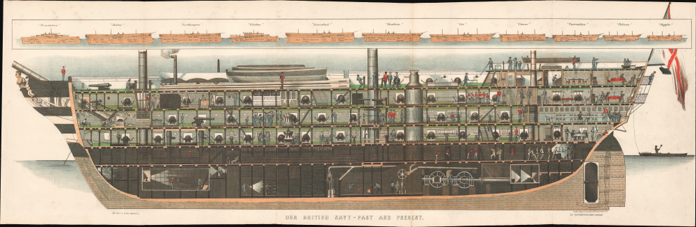


Title
Our British Navy - Past and Present.
1882 (undated) 11.5 x 35.25 in (29.21 x 89.535 cm)
1882 (undated) 11.5 x 35.25 in (29.21 x 89.535 cm)
Description
FOR THE ORIGINAL ANTIQUE MAP, WITH HISTORICAL ANALYSIS, CLICK HERE.
Digital Map Information
Geographicus maintains an archive of high-resolution rare map scans. We scan our maps at 300 DPI or higher, with newer images being 600 DPI, (either TIFF or JPEG, depending on when the scan was done) which is most cases in suitable for enlargement and printing.
Delivery
Once you purchase our digital scan service, you will receive a download link via email - usually within seconds. Digital orders are delivered as ZIP files, an industry standard file compression protocol that any computer should be able to unpack. Some of our files are very large, and can take some time to download. Most files are saved into your computer's 'Downloads' folder. All delivery is electronic. No physical product is shipped.
Credit and Scope of Use
You can use your digial image any way you want! Our digital images are unrestricted by copyright and can be used, modified, and published freely. The textual description that accompanies the original antique map is not included in the sale of digital images and remains protected by copyright. That said, we put significant care and effort into scanning and editing these maps, and we’d appreciate a credit when possible. Should you wish to credit us, please use the following credit line:
Courtesy of Geographicus Rare Antique Maps (https://www.geographicus.com).
How Large Can I Print?
In general, at 300 DPI, you should at least be able to double the size of the actual image, more so with our 600 DPI images. So, if the original was 10 x 12 inches, you can print at 20 x 24 inches, without quality loss. If your display requirements can accommodate some loss in image quality, you can make it even larger. That being said, no quality of scan will allow you to blow up at 10 x 12 inch map to wall size without significant quality loss. For more information, it is best consult a printer or reprographics specialist.
Refunds
If the high resolution image you ordered is unavailable, we will fully refund your purchase. Otherwise, digital images scans are a service, not a tangible product, and cannot be returned or refunded once the download link is used.
Cartographer
Emrik & Binger (fl. 1857 - 1927) was a Dutch lithography firm based in Haarlem. The firm was founded by Charles Binger (February 25, 1830 - February 14, 1916) and David Ozer Emrik (May 23, 1809 - December 27, 1883) in 1857. The older Emrik handled the administrative and financial aspects of the firm while Binger focues on the technical side and production. Binger married Emrik's daughter, Jeanette, further binding the two partners. Their earliest known work is a business card dating to 1858. In the early 1860s they began to embrace the new science of photography and won several awards for their work at various expositions and were highly successful. Emrik died in December of 1883. Charles Binger continued to manage the firm on his own, but passed the firm's management on to his son Maurice, and the sons of David Emrik, Orest David Herman and David, in 1896. The firm continued to operate until about 1927. More by this mapmaker...
Source
The Boy's Own Journal (London), November 1882.
References
National Maritime Museum ZBA2192. BM 1977,U.606.