Digital Image: 1931 Herrmann Zionist Bird's Eye View Map of Israel / Palestine
Palastina-herrmann-1931_d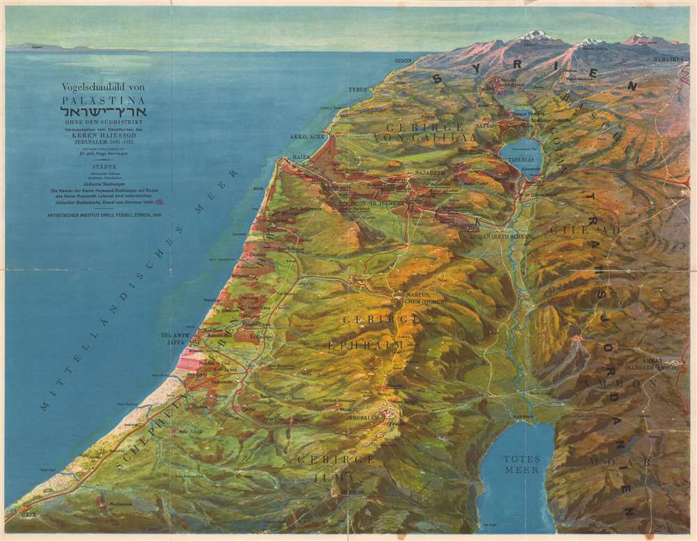

Title
Vogelschaubild von Palästina ארץ - ישראל Ohne den Süddistrikt.
1931 (dated) 15 x 19.25 in (38.1 x 48.895 cm)
1931 (dated) 15 x 19.25 in (38.1 x 48.895 cm)
Description
FOR THE ORIGINAL ANTIQUE MAP, WITH HISTORICAL ANALYSIS, CLICK HERE.
Digital Map Information
Geographicus maintains an archive of high-resolution rare map scans. We scan our maps at 300 DPI or higher, with newer images being 600 DPI, (either TIFF or JPEG, depending on when the scan was done) which is most cases in suitable for enlargement and printing.
Delivery
Once you purchase our digital scan service, you will receive a download link via email - usually within seconds. Digital orders are delivered as ZIP files, an industry standard file compression protocol that any computer should be able to unpack. Some of our files are very large, and can take some time to download. Most files are saved into your computer's 'Downloads' folder. All delivery is electronic. No physical product is shipped.
Credit and Scope of Use
You can use your digial image any way you want! Our digital images are unrestricted by copyright and can be used, modified, and published freely. The textual description that accompanies the original antique map is not included in the sale of digital images and remains protected by copyright. That said, we put significant care and effort into scanning and editing these maps, and we’d appreciate a credit when possible. Should you wish to credit us, please use the following credit line:
Courtesy of Geographicus Rare Antique Maps (https://www.geographicus.com).
How Large Can I Print?
In general, at 300 DPI, you should at least be able to double the size of the actual image, more so with our 600 DPI images. So, if the original was 10 x 12 inches, you can print at 20 x 24 inches, without quality loss. If your display requirements can accommodate some loss in image quality, you can make it even larger. That being said, no quality of scan will allow you to blow up at 10 x 12 inch map to wall size without significant quality loss. For more information, it is best consult a printer or reprographics specialist.
Refunds
If the high resolution image you ordered is unavailable, we will fully refund your purchase. Otherwise, digital images scans are a service, not a tangible product, and cannot be returned or refunded once the download link is used.
Cartographer
Dr. Hugo Hermann (1887 - 1940) was a Czech author, journalist, and Zionist activist primarily remembered for his political activism, but he was also an gifted analyst of German and Italian literature. Born in Moravská Trebová in what was then Austria-Hungary, Herrmann grew up in an assimilated German-speaking Jewish home. He attended universities in both Prague and Vienna and studied German and Romance philology. It was during his time as a student that he developed an interest in Zionism. Hermann served as secretary of the Zionist Organization of Bohemia from 1909 though 1912, and held the position of chairman of the Bar Kochba Association, a Zionist group in Prague, from 1909 until 1910. After completing his dissertation, Hermann briefly taught at a gymnasium before becoming the editor of Selbstwehr (Self-Defense), a Zionist political and literary weekly in Prague. He also served as editor in chief of the Jüdische Rundschau (Jewish Review), the main newspaper of the German Zionist Organization, from 1913 until the beginning of World War I. In 1925, Hermann wrote Eine werdende Welt (An Emerging World) describing his impressions after his first trip to Palestine. He later published works discussing the Arab Question in Palestine, a textbook on Palestine, and a work entitled Palästine Wie es wirklich its (Palestine as It Really Is). He moved to Palestine in 1934 and published two works while living there. His final publication, a semiautobiographical work, continues to be regarded as one of the best sources for the study of recent generations of rural Jews in Bohemia and Moravia. Hermann died in Jerusalem. More by this mapmaker...