1861 Vandermaelen / du Graty Map of Paraguay
Paraguay-vandermaelen-1861$950.00
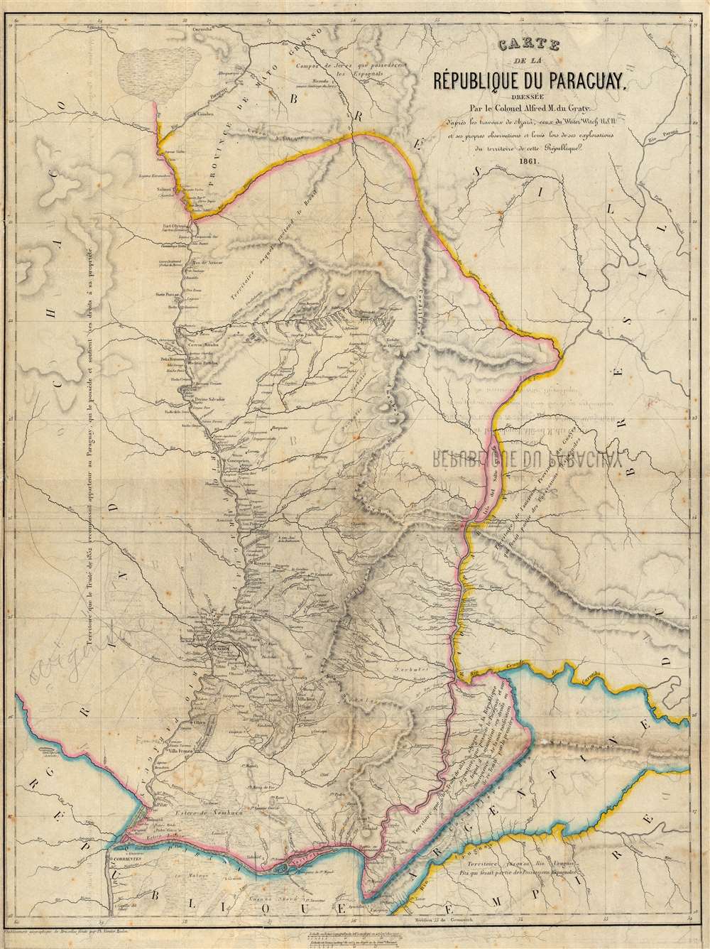

Title
Carte de la République du Paraguay, Dressée Par le Colonel Alfred M. du Graty.
1861 (dated) 26 x 20 in (66.04 x 50.8 cm) 1 : 1570000
1861 (dated) 26 x 20 in (66.04 x 50.8 cm) 1 : 1570000
Description
A scarce 1861 Philippe Vandermaelen map of the Republic of Paraguay. The map was built upon the groundbreaking 1809 work by Spanish military engineer Félix de Azara, updated from contemporaneous sources: the reports of the riverine exploration of the United States Navy and the travels of the Belgian noble and military adventurer Baron Alfred Louis Hubert Ghislain Marbais du Graty.
Surveys and Gunboat Diplomacy
One source credited in the map is the USN Water Witch. This U.S. Navy gunboat's 1855 cruise would not have shed much light on this region because its progress was arrested at the mouth of the Paraná, having come under fire by Paraguayan forces at Fort Itaipu. The engagement resulted in the death of helmsman Samuel Chaney, the curtailment of the surveying mission on the Paraná, and an international falling-out between Paraguay and the United States, which would not be resolved until the return in 1858 of Water Witch to Paraguay, this time in company of a full squadron successfully tasked to exact an apology and an indemnity over the 1855 incident.The Belgian Military Adventurer
The map also credits the efforts of Baron Alfred Marbais du Graty, who fought in the service of Argentinian General Justo José de Urquiza during the 1851 'Platine War' and served as part of the Urquiza government to 1861 or early 1862. Du Graty's military service took him along the Paraná River, and his specialty as a naturalist - Paraguay's meliponiculture - further developed his familiarity with the Republic. Following the decline of the Argentine Urquiza presidency, du Graty returned to Belgium to serve as Paraguay's Charge d'Affaires. During his tenure as a diplomat on behalf of the Republic, he wrote the book for which this map was intended.Conflicting Territorial Claims
The borders of Paraguay and her neighbors were subject to overlapping claims between that country, Bolivia, and the Argentine Confederation. These claims were central to treaties and wars between the neighboring countries. A July 19, 1852, treaty between the Argentine Confederation and Paraguay (following the 1851-52 Platine War) was written to dispose of two areas: the Misiones region (southeast of the Paraná River), assigned to Argentina, and the area west of the Paraguay River, assigned to Paraguay. Both these areas are marked on the map. There is an explanation that the Misiones, despite belonging to Argentina by the treaty, were administered and claimed by Paraguay. Pencil notation between the Rio Vermejo and the Rio Pilcomayo identifies that area - known as Formosa - as 'Argentine.' The claims to these territories remained sticking points in the political relations of the La Plata, but not so much as did the rights for travel on the rivers - over which Paraguay jealously exercised control.Publication History and Census
The map was printed by Vandermaelen for inclusion in du Graty's 1862 La République du Paraguay. While the volume is well-represented in institutional collections, the map is not always present. We find only one example of the separate map, located in the Bibliothèque National de France.CartographerS
Philippe Marie Guillaume Vandermaelen (December 23, 1795 - May 29, 1869) was a Flemish cartographer active in Brussels during the first part of the 19th century. Vandermaelen is created with "one of the most remarkable developments of private enterprise in cartography," namely his remarkable six volume Atlas Universel de Geographie. Vandermaelen was born in Brussels in 1795 and trained as a globe maker. It was no doubt his training as a globe maker that led him see the need for an atlas rendered on a universal scale in order that all bodies could be understood in relation to one another. In addition to his great work Vandermaelen also produced a number of globes, lesser maps, a highly detailed 250 sheet map of Belgium, and several regional atlases. More by this mapmaker...
Alfred Marbais du Graty (December 5, 1823 - March 20, 1891) was a Belgian naturalist, geographer and historian. He was born to the aristocracy in Belgium, and was educated in Brussels at military school, thereafter beginning a military career. He was assigned as an attaché to the Belgian delegation to Rio de Janeiro in 1850. In 1851 following year he served as an artillery sergeant major to General Justo José de Urquiza, fighting against the Caudillo Juan Manuel de Rosas. Urquiza enlisted him into the Entre Ríos army, a san artillery sergeant major. De Rosas had been leading an expansionist movement, which was then countered by Brazil's support of Uruguay in its struggle against Argentina; Du Graty's support of De Rosa's enemy Urquiza during this so-called 'Platine War' appears to have been in concert with Brazil's efforts. Du Graty's service took place on the Paraná River, as well as the 1852 Battle of Caseros. His efforts were rewarded: he was two years later numbered among the naturalists and thinkers invited by Urquiza to survey the Argentinian Entre Rios province in 1853; after Urquiza became President, he appointed Du Graty in 1854 to be his aide-de-camp and promoted to Colonel. Du Graty would parlay his military successes to the benefit of science: He created the National Museum in Paraná to which he was appointed director; he worked there until 1857. Thereafter he contracted for the exploitation of mines in Catamarca, northwestern Argentina. He would administer these personally, and would in 1855 promote Argentine mining at the International Exhibition in Paris. He held elected office in the Argentine province of Tucumán from 1856 to 1858. He became an Argentine citizen in 1858. Du Graty began a career in journalism, both as an editor of El Nacional Argentino a governmental organ. At the turn of Urquiza's fortunes in the 1861 battle of Pavón, Du Graty returned to Belgium, where the Paraguayan government would designate him Charge d'Affaires. He wrote several books: the 1858 a Confederación Argentina and the 1861 a República del Paraguay. Before his death, he would go on to serve in Belgium as Undersecretary of State in the Ministries of Finance and Foreign Relations, and would become and was the Founding Director of the National Museum.
A naturalist, du Graty was also forward in Paraguay's meliponiculture, the study of the care and keeping of stingless bees. Learn More...
Source
Marbais du Graty, Alfred, La République du Paraguay, (Bruxelles, Muquardt) 1862.
Condition
Good. Archivally backed, with some mends at margins and junctures of folds. Some offsetting, and pencil notation. Original outline color.
References
Rumsey 122499.022. OCLC 494820530.