Digital Image: 1660 Nicolas Berey View Map of Paris, France
Paris-berey-1660_d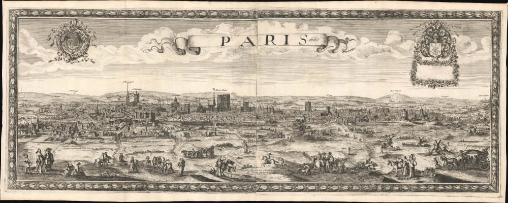


Title
Paris 1660.
1660 (dated) 17 x 42.75 in (43.18 x 108.585 cm)
1660 (dated) 17 x 42.75 in (43.18 x 108.585 cm)
Description
FOR THE ORIGINAL ANTIQUE MAP, WITH HISTORICAL ANALYSIS, CLICK HERE.
Digital Map Information
Geographicus maintains an archive of high-resolution rare map scans. We scan our maps at 300 DPI or higher, with newer images being 600 DPI, (either TIFF or JPEG, depending on when the scan was done) which is most cases in suitable for enlargement and printing.
Delivery
Once you purchase our digital scan service, you will receive a download link via email - usually within seconds. Digital orders are delivered as ZIP files, an industry standard file compression protocol that any computer should be able to unpack. Some of our files are very large, and can take some time to download. Most files are saved into your computer's 'Downloads' folder. All delivery is electronic. No physical product is shipped.
Credit and Scope of Use
You can use your digial image any way you want! Our digital images are unrestricted by copyright and can be used, modified, and published freely. The textual description that accompanies the original antique map is not included in the sale of digital images and remains protected by copyright. That said, we put significant care and effort into scanning and editing these maps, and we’d appreciate a credit when possible. Should you wish to credit us, please use the following credit line:
Courtesy of Geographicus Rare Antique Maps (https://www.geographicus.com).
How Large Can I Print?
In general, at 300 DPI, you should at least be able to double the size of the actual image, more so with our 600 DPI images. So, if the original was 10 x 12 inches, you can print at 20 x 24 inches, without quality loss. If your display requirements can accommodate some loss in image quality, you can make it even larger. That being said, no quality of scan will allow you to blow up at 10 x 12 inch map to wall size without significant quality loss. For more information, it is best consult a printer or reprographics specialist.
Refunds
If the high resolution image you ordered is unavailable, we will fully refund your purchase. Otherwise, digital images scans are a service, not a tangible product, and cannot be returned or refunded once the download link is used.
Cartographer
Nicolas Berey (1610 - June 30, 1665) was a French publisher of maps and views active in Paris in the first half of the 17th century. There is some confusion regarding Berey, as the name was used simultaneously by both father and son, who operated out of the same location and died within two years of one another. For our purposes, they will be distinguished as Nicolas I Berey and the son as Nicolas II Berey (1640 - December 1667). The elder Berey, Nicolas I, was born in 1610, likely in Chaource, France. From at least 1644, he established himself in the print trade with a shop in the print dealer's district on Quai des Augustins in Paris, with the sign Les Deux Globes (The Two Globes), signing his work as A Paris chez Nicolas Berey proche les Augustins. The younger Berey, Nicolas II, was born in Paris in 1640 and live only until December 1667, dying at just 27 of unknown causes. Both men held the designation Enlumineur de la Reine. When Nicholas II died, ownership and management of Les Deux Globes passed to Nicholas I's daughter, Jeanne, who was married to Alexis-Hubert Jaillot (c. 1632 - 1712). Jumpstarting from the substantial Berey base, and republishing many of their works, Jaillot became a publishing tour de force, dominating the French map publishing trade for decades. More by this mapmaker...