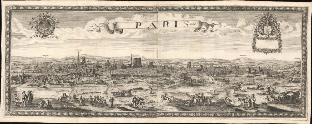
1660 Nicolas Berey View Map of Paris, France
Paris-berey-1660$22,000.00


Title
Paris 1660.
1660 (dated) 17 x 42.75 in (43.18 x 108.585 cm)
1660 (dated) 17 x 42.75 in (43.18 x 108.585 cm)
Description
This is the only known example of Nöel Cochin and Nicolas Berey's 1660 view of Paris - the earliest known large-format view of Paris published in Paris (an earlier large view was issued in Amsterdam). This view is likely a proof state or perhaps a study for a larger view of the same issued two years later in 1662 (c.f. Boutier #105).
Prominent landmarks visible in the scene, moving from left to right, include:
In the foreground are lively illustrations of Parisian aristocrats, merchants, and citizens enjoying leisure time in the rural outskirts. In a nod of acknowledgment to Matthäus Merian (1593 - 1650), whose 1638 view Parys doubtless inspired this much grander work, Cochin follows suit and incorporates himself among those in the foreground, a seated artist sketching this very image.
A Closer Look
The panoramic view looks southeast on Paris from Charonne to the northwest, part of the modern-day 20th Arrondissement, located just south of the famous Cimetière du Père-Lachaise. Coverage extends from the Faubourg and Abbaye de Saint-Antoine in the southeast to the hills of Montmartre in the northwest.Prominent landmarks visible in the scene, moving from left to right, include:
- Faubourg Saint-Antoine
- Faubourg Saint-Marceau
- Les Cordeliers
- Faubourg Saint-Jacques
- The Bastille
- Former cathedral of Saint-Étienne
- The Sorbonne
- Notre-Dame
- Church of Saint-Gervais
- The Louvre
- Old Grosse Tour of the Temple
- Montmartre
In the foreground are lively illustrations of Parisian aristocrats, merchants, and citizens enjoying leisure time in the rural outskirts. In a nod of acknowledgment to Matthäus Merian (1593 - 1650), whose 1638 view Parys doubtless inspired this much grander work, Cochin follows suit and incorporates himself among those in the foreground, a seated artist sketching this very image.
Publication History and Census
This view was engraved and printed in 1660. As such, it must be considered the first large-scale view of Paris printed in Paris. The view was drawn by Noël Cochin and published by Nicolas Berey, likely the elder. Scratch marks and plate haze suggest this is an early strike off the plate, and in fact, the blank rectangular floral frame in the upper right strongly suggests it is an incomplete proof - typically, there would be a dedication here. This is further underscored by this piece's unique rarity, this being the only known example. Berey reintroduced the image in a new double-sized, though more crudely engraved, plate in 1662, with an elaborate surround. Although also rare, that larger view is known in 3 states and about 6 examples, making it, compared to the present view, relatively common.Cartographer
Nicolas Berey (1610 - June 30, 1665) was a French publisher of maps and views active in Paris in the first half of the 17th century. There is some confusion regarding Berey, as the name was used simultaneously by both father and son, who operated out of the same location and died within two years of one another. For our purposes, they will be distinguished as Nicolas I Berey and the son as Nicolas II Berey (1640 - December 1667). The elder Berey, Nicolas I, was born in 1610, likely in Chaource, France. From at least 1644, he established himself in the print trade with a shop in the print dealer's district on Quai des Augustins in Paris, with the sign Les Deux Globes (The Two Globes), signing his work as A Paris chez Nicolas Berey proche les Augustins. The younger Berey, Nicolas II, was born in Paris in 1640 and live only until December 1667, dying at just 27 of unknown causes. Both men held the designation Enlumineur de la Reine. When Nicholas II died, ownership and management of Les Deux Globes passed to Nicholas I's daughter, Jeanne, who was married to Alexis-Hubert Jaillot (c. 1632 - 1712). Jumpstarting from the substantial Berey base, and republishing many of their works, Jaillot became a publishing tour de force, dominating the French map publishing trade for decades. More by this mapmaker...
Condition
Fine. Original folds.