1931 Leconte and Guilmin Pictorial Map of Paris / Map of Colonial Exposition
ParisExpositionColoniale-leconteguilmin-1931$350.00

Title
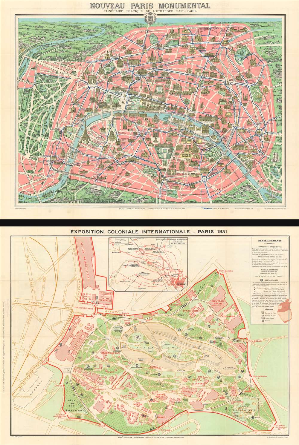
Nouveau Paris Monumental. / Exposition Coloniale Internationale - Paris 1931.
1931 (dated) 21 x 27.75 in (53.34 x 70.485 cm)
1931 (dated) 21 x 27.75 in (53.34 x 70.485 cm)
Description
This is a 1931 Leconte and Guilmin pictorial map of Paris with a map of the 1931 Paris International Colonial Exposition on the verso.
Even though it was billed as an 'international exposition', and numerous European countries and the United States had pavilions there, the exposition's stated goal was to impress upon the French people the glory of their empire and that it worked for them, while emphasizing the French colonial philosophy of the 'civilizing mission'. This meant that, by far, the exposition's focus was on French colonies, with areas devoted to French Indochina, Algeria, Tunisia, Madagascar, and Morocco. The French also imported colonial people to inhabit these pavilions, to give them a more 'local' feel. In the end, this exposition was one of the most successful in French history, with over 8 million visitors and a profit of over 33 million francs.
Nouveau Paris Monumental
The pictorial map of Paris depicts the city from the Bois de Boulogne to the Bois de Vincennes, where the Colonial Exposition was being held. Parisian suburbs are labeled on all four sides, some of which are marked by houses and other buildings drawn in profile. The highlight of the map is, of course, Paris's many wonderful buildings drawn in profile, providing the tourist with a beautiful and practical souvenir. The Louvre, the Arc de Triomphe, the Eiffel Tower, Sacre-Coeur, and many other sites throughout Paris are highlighted. Paris's many churches and cathedrals, including Notre Dame and St. Germain-des-Près, are celebrated, as are the city's incredible parks, the Jardin du Luxembourg, the Jardin des Plantes, and the Parc des Buttes-Chaumont. The city's subway network is also illustrated, with the lines and the stations shown in blue.The 1931 Paris International Colonial Exposition
The 1931 Paris International Colonial Exposition was a project nearly 25 years in the making. Planning for the exposition began in 1906, and, between opposition from the rest of France to yet another exposition being held in Paris, and the First World War, the exposition was not opened until May 1931. Held in the Bois de Vincennes and constructed around Daumesnil Lake, the exposition was the largest world's fair ever attempted in Paris, covering over 500 acres. The 1931 Paris International Colonial Exposition also has the distinction of being one of the few, if not the only, international exposition held in Paris that did not feel crowded. It was also an architectural marvel, with reconstructions of indigenous architecture from all over the world presented to the French people. Among these were monumental thatched-roof buildings designed by French architects after African huts and a reconstruction of Angkor Wat. A railroad encircled the whole exposition, allowing visitors to ride around the outside and view the architecture in relative comfort.Even though it was billed as an 'international exposition', and numerous European countries and the United States had pavilions there, the exposition's stated goal was to impress upon the French people the glory of their empire and that it worked for them, while emphasizing the French colonial philosophy of the 'civilizing mission'. This meant that, by far, the exposition's focus was on French colonies, with areas devoted to French Indochina, Algeria, Tunisia, Madagascar, and Morocco. The French also imported colonial people to inhabit these pavilions, to give them a more 'local' feel. In the end, this exposition was one of the most successful in French history, with over 8 million visitors and a profit of over 33 million francs.
Publication History
This map was published by Leconte and Guilmin and printed by the Imprimerie Dufrénoy in 1931. The map of the Paris International Colonial Exposition was created by L. Bergelin. Monumental maps of Paris had been published in various forms beginning in the 1880s.CartographerS
L. Guilmin (fl. c. 1890 - c. 1933) was a French map and book publisher active in the late 18th and early 19th century. Guilmin has a large corpus of work, but remains personally obscure. His maps begin appearing in the 1890s and continue to appear until the 1930s. He is sometimes associated with A. Leconte and L. Joly, two other prominent Parisian publishers of the period. At various time he had offices at 90 Boulevard Voltaire, 63 Boulevard Voltaire, and 38 Rue Sainte-Croix-de-la-Bretonnerie. More by this mapmaker...
André Leconte (fl. 1880 - 1930) was a Paris based guidebook and map publisher active in the latter part of the 19th and early 20th centuries. He is one of the publishers of the attractive art nouveau style "Nouveau Paris Monumental" series. Leconte is often associated with L. Guilmin, another Paris based map publisher of the same period. Early in World War II (1939 - 1945) the firm published anti-German propaganda, but briefly shut down operations during the occupation. Leconte's name appears on maps and guidebooks of Paris well after his death (though we can't date this event with any precision) to about 1980. Learn More...
Eugène Dufrenoy (January 21, 1834 - 190x), aka Dufrenois, was a French printer, lithographer, and engraver active in Paris during the second half of the 19th and the early 20th centuries. Dufrénoy born in Bourg-la-Reine, in what is today the southern suburbs of Paris. He was based, for at least part of his career, at 34 Rue du Four, Paris. In 1881 Dufrénoy acquired a large space at 49 Rue du Montparnasse. This space still operates as a printshop with Dufrénoy's old presses as IDEM Paris. ˜ Learn More...
L. Bergelin (fl. c. 1930 - c. 1972) was a French cartographer active during the mid-20th century. He produced school wall maps, world maps, and city plans, notably of Paris. From 1838, he also worked on the Peugeot road atlas beginning. Learn More...
Condition
Very good. Even overall toning. Light wear along original fold lines.Area of discoloration where previously attached to cardboard binder. Pictorial map of Paris on recto and map or plan of 1931 Colonial Exposition on verso.