Digital Image: 1870 Beers Map of Pawtucket, Rhode Island
PawtucketRhodeIsland-beers-1870_d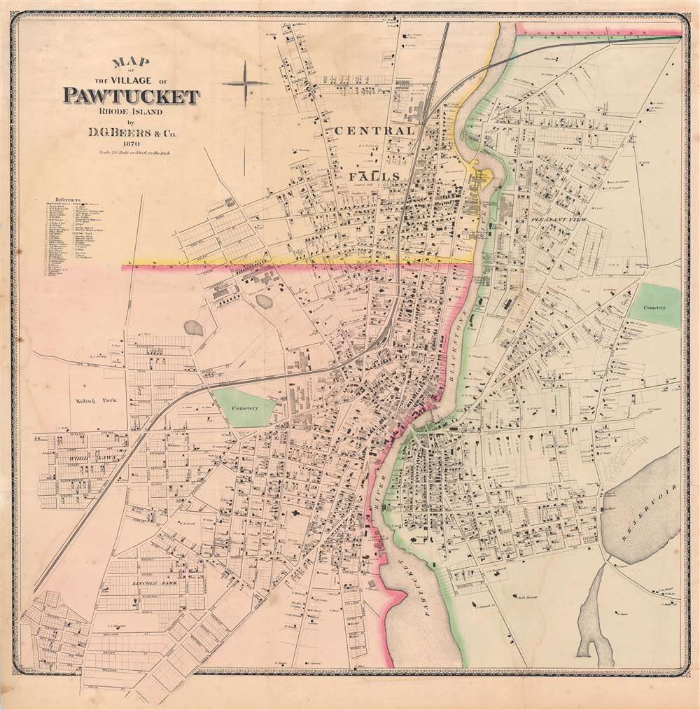

Title
Map of the Village of Pawtucket Rhode Island.
1870 (dated) 33 x 32.5 in (83.82 x 82.55 cm) 1 : 3960
1870 (dated) 33 x 32.5 in (83.82 x 82.55 cm) 1 : 3960
Description
FOR THE ORIGINAL ANTIQUE MAP, WITH HISTORICAL ANALYSIS, CLICK HERE.
Digital Map Information
Geographicus maintains an archive of high-resolution rare map scans. We scan our maps at 300 DPI or higher, with newer images being 600 DPI, (either TIFF or JPEG, depending on when the scan was done) which is most cases in suitable for enlargement and printing.
Delivery
Once you purchase our digital scan service, you will receive a download link via email - usually within seconds. Digital orders are delivered as ZIP files, an industry standard file compression protocol that any computer should be able to unpack. Some of our files are very large, and can take some time to download. Most files are saved into your computer's 'Downloads' folder. All delivery is electronic. No physical product is shipped.
Credit and Scope of Use
You can use your digial image any way you want! Our digital images are unrestricted by copyright and can be used, modified, and published freely. The textual description that accompanies the original antique map is not included in the sale of digital images and remains protected by copyright. That said, we put significant care and effort into scanning and editing these maps, and we’d appreciate a credit when possible. Should you wish to credit us, please use the following credit line:
Courtesy of Geographicus Rare Antique Maps (https://www.geographicus.com).
How Large Can I Print?
In general, at 300 DPI, you should at least be able to double the size of the actual image, more so with our 600 DPI images. So, if the original was 10 x 12 inches, you can print at 20 x 24 inches, without quality loss. If your display requirements can accommodate some loss in image quality, you can make it even larger. That being said, no quality of scan will allow you to blow up at 10 x 12 inch map to wall size without significant quality loss. For more information, it is best consult a printer or reprographics specialist.
Refunds
If the high resolution image you ordered is unavailable, we will fully refund your purchase. Otherwise, digital images scans are a service, not a tangible product, and cannot be returned or refunded once the download link is used.
Cartographer
Daniel Glover Beers (October 19, 1841 - February 12, 1913) was an American farmer, surveyor, and mapmaker active in Connecticut. He is the brother of Silas Norman Beers (September 3, 1837 - May 12, 1873), son of Charles Henry Beers (November 3, 1813 - March 5, 1892), and nephew of Frederick William Beers (August 17, 1839 - September 8, 1933), all prominent mapmakers. D. G. Beer's name appears on the imprint of several Beers maps, including the large 1860 wall map of Philadelphia and vicinity, with Dunning Jackson Lake (1836 - 1915). In 1865 he partnered with one 'Pomeroy' of Rochester, New York to publish an Atlas of Delaware under the imprint of 'Pomeroy and Beers'. This business dissolved in 1880, after which he published independently as 'D. G. Beers and Co.' In the same year he patented a folding canvas canopy for covered wagons, a business that became extremely prosperous. More by this mapmaker...
Source
Beers, D. G., Atlas of the state of Rhode Island and Providence Plantations, (Philadelphia: D. G. Beers and Co.) 1870.
References
OCLC 1032335725. University of Southern Maine, Osher Map Library, G3774.P3 1870 B4.