This item has been sold, but you can get on the Waitlist to be notified if another example becomes available, or purchase a digital scan.
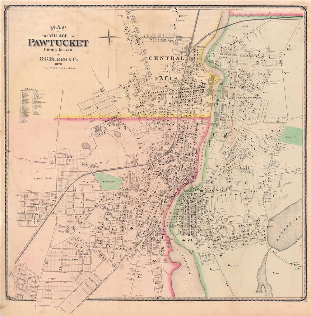
1870 Beers Map of Pawtucket, Rhode Island
PawtucketRhodeIsland-beers-1870$475.00


Title
Map of the Village of Pawtucket Rhode Island.
1870 (dated) 33 x 32.5 in (83.82 x 82.55 cm) 1 : 3960
1870 (dated) 33 x 32.5 in (83.82 x 82.55 cm) 1 : 3960
Description
A striking large-scale 1870 map of Pawtucket, Rhode Island by Daniel Glover Beers. The map details the town of Pawtucket on both sides of the Pawtucket and Blackstone rivers, just north of Providence and Narragansett Bay. The meticulously detailed map names every street and building lot, in many cases offering building footprints and naming property owners.
Publication History and Census
This map was prepared by Daniel Glover Beers for publication in his 1870 Atlas of the state of Rhode Island and Providence Plantations. It was one of several large-scale folding maps included with the atlas, the compilation of existing maps and unique survey work performed by Beers himself. It is likely the best map of Pawtucket to appear in the late 19th century. While the Beers atlas is well represented institutionally, the separate map is named only at the Osher Map Library, University of Southern Maine. It is scarce to the market.Cartographer
Daniel Glover Beers (October 19, 1841 - February 12, 1913) was an American farmer, surveyor, and mapmaker active in Connecticut. He is the brother of Silas Norman Beers (September 3, 1837 - May 12, 1873), son of Charles Henry Beers (November 3, 1813 - March 5, 1892), and nephew of Frederick William Beers (August 17, 1839 - September 8, 1933), all prominent mapmakers. D. G. Beer's name appears on the imprint of several Beers maps, including the large 1860 wall map of Philadelphia and vicinity, with Dunning Jackson Lake (1836 - 1915). In 1865 he partnered with one 'Pomeroy' of Rochester, New York to publish an Atlas of Delaware under the imprint of 'Pomeroy and Beers'. This business dissolved in 1880, after which he published independently as 'D. G. Beers and Co.' In the same year he patented a folding canvas canopy for covered wagons, a business that became extremely prosperous. More by this mapmaker...
Source
Beers, D. G., Atlas of the state of Rhode Island and Providence Plantations, (Philadelphia: D. G. Beers and Co.) 1870.
Condition
Good. Minor wear on old fold lines. Minor dampstaining. Several large closed near invisible tears near center and at edges repaired and reinforced on verso.
References
OCLC 1032335725. University of Southern Maine, Osher Map Library, G3774.P3 1870 B4.