Digital Image: 1838 J. Riegel Pictorial Map of Philadelphia, showing Fire Companies
PhiladelphiaFireCompanies-riegel-1938-2_d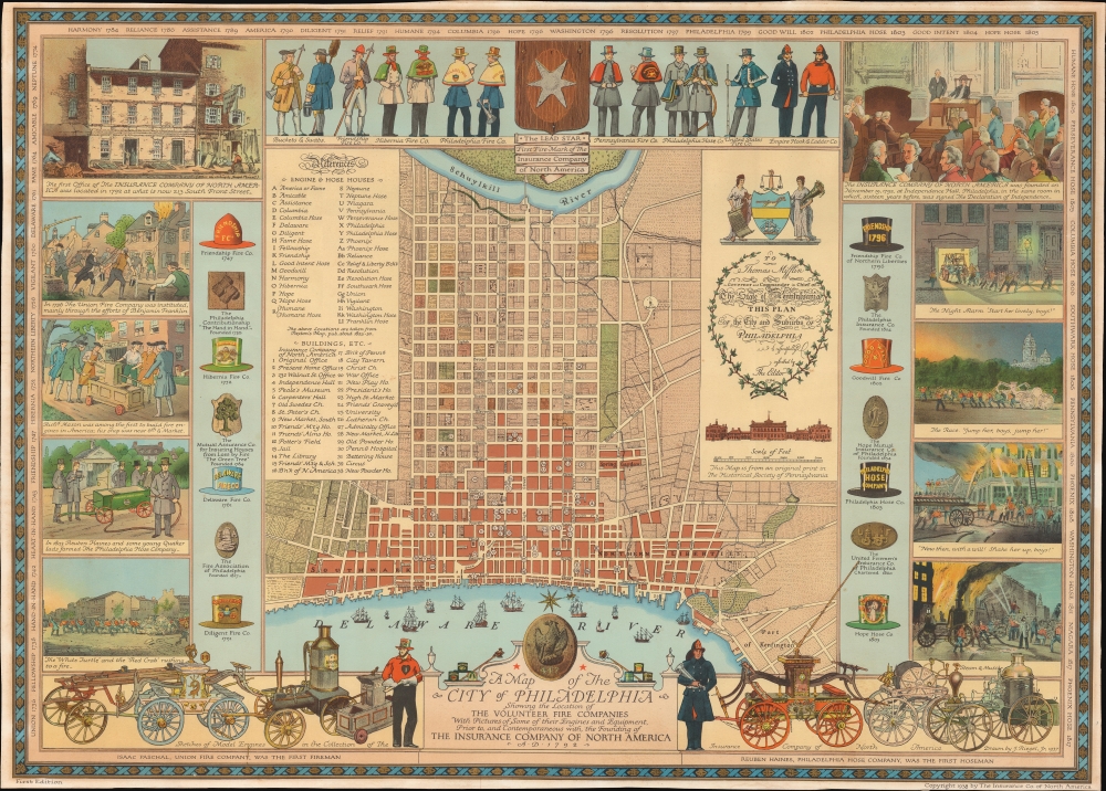


Title
A Map of the City of Philadelphia Showing the Location of the Volunteer Fire Companies with Pictures of Some of their Engines and Equipment, Prior to, and Contemporaneous with, the Founding of the Insurance Company of North America.
1938 (dated) 21.5 x 30 in (54.61 x 76.2 cm) 1 : 12500
1938 (dated) 21.5 x 30 in (54.61 x 76.2 cm) 1 : 12500
Description
FOR THE ORIGINAL ANTIQUE MAP, WITH HISTORICAL ANALYSIS, CLICK HERE.
Digital Map Information
Geographicus maintains an archive of high-resolution rare map scans. We scan our maps at 300 DPI or higher, with newer images being 600 DPI, (either TIFF or JPEG, depending on when the scan was done) which is most cases in suitable for enlargement and printing.
Delivery
Once you purchase our digital scan service, you will receive a download link via email - usually within seconds. Digital orders are delivered as ZIP files, an industry standard file compression protocol that any computer should be able to unpack. Some of our files are very large, and can take some time to download. Most files are saved into your computer's 'Downloads' folder. All delivery is electronic. No physical product is shipped.
Credit and Scope of Use
You can use your digial image any way you want! Our digital images are unrestricted by copyright and can be used, modified, and published freely. The textual description that accompanies the original antique map is not included in the sale of digital images and remains protected by copyright. That said, we put significant care and effort into scanning and editing these maps, and we’d appreciate a credit when possible. Should you wish to credit us, please use the following credit line:
Courtesy of Geographicus Rare Antique Maps (https://www.geographicus.com).
How Large Can I Print?
In general, at 300 DPI, you should at least be able to double the size of the actual image, more so with our 600 DPI images. So, if the original was 10 x 12 inches, you can print at 20 x 24 inches, without quality loss. If your display requirements can accommodate some loss in image quality, you can make it even larger. That being said, no quality of scan will allow you to blow up at 10 x 12 inch map to wall size without significant quality loss. For more information, it is best consult a printer or reprographics specialist.
Refunds
If the high resolution image you ordered is unavailable, we will fully refund your purchase. Otherwise, digital images scans are a service, not a tangible product, and cannot be returned or refunded once the download link is used.
Cartographer
Jacob Riegel Jr. (October 26, 1889 – June 13, 1959) was an artist known for his pictorial maps. Riegel was born in Philadelphia. Like his father before him he attended Princeton University from which he graduated in 1912. During World War I, Riegel joined the Army Sanitary Corps, and after basic training at Fort McPherson, was sent abroad with the rank of Sergeant. In 1916 he joined the art department at the Philadelphia lithography and printing firm of John Louis Ketterlinus and Company. Riegel produced artwork for greeting cards, book plates, armorial crests, and of course, pictorial maps. HIs art became quite popular, enough that c. 1930, he contracted the Engle Press of Philadelphia to reproduce his work upon request. Riegel lived at 6003 Wayne Avenue, and later at 55 Schoolhouse Lane, both in Germantown, PA. He is interred at Laurel Hill Cemetery in Philadelphia PA. More by this mapmaker...
References
Rumsey 8134.000. OCLC 51309468.