This item has been sold, but you can get on the Waitlist to be notified if another example becomes available, or purchase a digital scan.
1838 J. Riegel Pictorial Map of Philadelphia, showing Fire Companies
PhiladelphiaFireCompanies-riegel-1938-2$375.00


Title
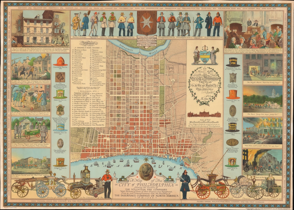
A Map of the City of Philadelphia Showing the Location of the Volunteer Fire Companies with Pictures of Some of their Engines and Equipment, Prior to, and Contemporaneous with, the Founding of the Insurance Company of North America.
1938 (dated) 21.5 x 30 in (54.61 x 76.2 cm) 1 : 12500
1938 (dated) 21.5 x 30 in (54.61 x 76.2 cm) 1 : 12500
Description
A first edition 1938 pictorial map of the city of Philadelphia celebrating that city's 19th century volunteer fire companies and the Insurance Company of North America. Volunteer Fire Companies, active throughout the 19th century, were powerful players in Philadelphia's social, political, and even criminal organizations.
A Closer Look
Based upon a 1937 drawing by J. Riegel, the map focuses on the downtown area of modern Philadelphia between the Delaware River and the Schuylkill River and is derived from a historic map dating to 1794. Riegel has identified the sites of various Engine and Hose Houses throughout. Surrounding the map are illustrations of fire companies at work, including renderings of their costumes and logos. Along the bottom are sketches of historic fire engines, apparently all drawn from models in the collection of the Insurance Company of America. In the upper left the first offices of the 'Insurance Company of North America' are illustrated. In the upper right is an illustration of that same company's 1792 founding in Independence Hall - suggesting a connection between the company and patriotism.Philadelphia's Volunteer Fire Companies
In the 19th century, Philadelphia's firefighting efforts were dominated by volunteer fire companies, which served as far more than mere emergency responders. These entities doubled as social clubs and political organizations, sometimes exhibited gang-like behavior. Their passionate rivalries occasionally resulted in street 'wars,' leading to instances where companies would clash with one another at the scene of a fire rather than 'firefighting'. Despite their fervor and dedication, the inefficiencies and dangers of such unregulated competition prompted the city to transition towards a more structured, professional firefighting system by the latter part of the century.Insurance Company of North America
The Insurance Company of North America (INA), established in 1792 in Philadelphia, is the oldest stock insurance company in the United States. A testament to American enterprise in the post-Revolutionary era, the INA offered fire, marine, and life policies. As the nation's commercial activities expanded, so did INA's influence and reach, playing a pivotal role in underwriting American mercantile and territorial expansion. Over the centuries, through mergers and acquisitions, the INA became a part of larger insurance entities, eventually merging with Connecticut General Life Insurance Company in 1982 to form CIGNA, a global health services organization.Publication History and Census
This map was drawn in 1937 by Jacob Riegel Jr. and published in 1938 by the 'Insurance Company of North America'. It is the first and likely only edition.Cartographer
Jacob Riegel Jr. (October 26, 1889 – June 13, 1959) was an artist known for his pictorial maps. Riegel was born in Philadelphia. Like his father before him he attended Princeton University from which he graduated in 1912. During World War I, Riegel joined the Army Sanitary Corps, and after basic training at Fort McPherson, was sent abroad with the rank of Sergeant. In 1916 he joined the art department at the Philadelphia lithography and printing firm of John Louis Ketterlinus and Company. Riegel produced artwork for greeting cards, book plates, armorial crests, and of course, pictorial maps. HIs art became quite popular, enough that c. 1930, he contracted the Engle Press of Philadelphia to reproduce his work upon request. Riegel lived at 6003 Wayne Avenue, and later at 55 Schoolhouse Lane, both in Germantown, PA. He is interred at Laurel Hill Cemetery in Philadelphia PA. More by this mapmaker...
Condition
Very good. Wide margins. Backed on archival tissue.
References
Rumsey 8134.000. OCLC 51309468.