Digital Image: 1948 John Pictorial City Plan or Map of Miami, Florida
PictorialPlesurmapMiami-john-1948_d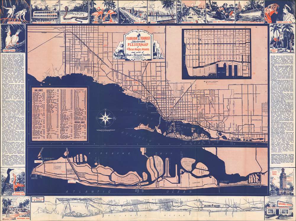


Title
Florida Tourist Pictorial Plesurmap of These Magic Miamis and parts of Dade and Broward Counties.
1948 (undated) 18 x 24 in (45.72 x 60.96 cm) 1 : 38600
1948 (undated) 18 x 24 in (45.72 x 60.96 cm) 1 : 38600
Description
FOR THE ORIGINAL ANTIQUE MAP, WITH HISTORICAL ANALYSIS, CLICK HERE.
Digital Map Information
Geographicus maintains an archive of high-resolution rare map scans. We scan our maps at 300 DPI or higher, with newer images being 600 DPI, (either TIFF or JPEG, depending on when the scan was done) which is most cases in suitable for enlargement and printing.
Delivery
Once you purchase our digital scan service, you will receive a download link via email - usually within seconds. Digital orders are delivered as ZIP files, an industry standard file compression protocol that any computer should be able to unpack. Some of our files are very large, and can take some time to download. Most files are saved into your computer's 'Downloads' folder. All delivery is electronic. No physical product is shipped.
Credit and Scope of Use
You can use your digial image any way you want! Our digital images are unrestricted by copyright and can be used, modified, and published freely. The textual description that accompanies the original antique map is not included in the sale of digital images and remains protected by copyright. That said, we put significant care and effort into scanning and editing these maps, and we’d appreciate a credit when possible. Should you wish to credit us, please use the following credit line:
Courtesy of Geographicus Rare Antique Maps (https://www.geographicus.com).
How Large Can I Print?
In general, at 300 DPI, you should at least be able to double the size of the actual image, more so with our 600 DPI images. So, if the original was 10 x 12 inches, you can print at 20 x 24 inches, without quality loss. If your display requirements can accommodate some loss in image quality, you can make it even larger. That being said, no quality of scan will allow you to blow up at 10 x 12 inch map to wall size without significant quality loss. For more information, it is best consult a printer or reprographics specialist.
Refunds
If the high resolution image you ordered is unavailable, we will fully refund your purchase. Otherwise, digital images scans are a service, not a tangible product, and cannot be returned or refunded once the download link is used.
Cartographer
Joseph William John (1892 - 1948 or 1949) was an American mapmaker and publisher. Born in Alabama, John owned a mapmaking and printing firm called Joseph W. John and Associates in Miami in the 1940s. John sued the Greater Miami Apartment House and the Advance Press, Inc. in 1943 for copyright infringement. The suit included $200,000 in damages. The case was settled out of court and the settlement amount was not published. John also sued the Overseas Highway Commission and Monroe County for similar copyright infringement concerning a map of Key West. More by this mapmaker...