Digital Image: 1796 D. F. Sotzmann Wall Map of the Partitioning of Poland
Poland-sotzmann-1796_d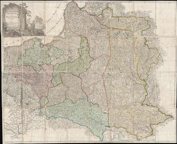

Title
Grenzkarte der Preussischen Russischen und Oestreichischen Monarchien in XVI Blättern.
1796 (dated) 39 x 48 in (99.06 x 121.92 cm) 1 : 1150000
1796 (dated) 39 x 48 in (99.06 x 121.92 cm) 1 : 1150000
Description
FOR THE ORIGINAL ANTIQUE MAP, WITH HISTORICAL ANALYSIS, CLICK HERE.
Digital Map Information
Geographicus maintains an archive of high-resolution rare map scans. We scan our maps at 300 DPI or higher, with newer images being 600 DPI, (either TIFF or JPEG, depending on when the scan was done) which is most cases in suitable for enlargement and printing.
Delivery
Once you purchase our digital scan service, you will receive a download link via email - usually within seconds. Digital orders are delivered as ZIP files, an industry standard file compression protocol that any computer should be able to unpack. Some of our files are very large, and can take some time to download. Most files are saved into your computer's 'Downloads' folder. All delivery is electronic. No physical product is shipped.
Credit and Scope of Use
You can use your digial image any way you want! Our digital images are unrestricted by copyright and can be used, modified, and published freely. The textual description that accompanies the original antique map is not included in the sale of digital images and remains protected by copyright. That said, we put significant care and effort into scanning and editing these maps, and we’d appreciate a credit when possible. Should you wish to credit us, please use the following credit line:
Courtesy of Geographicus Rare Antique Maps (https://www.geographicus.com).
How Large Can I Print?
In general, at 300 DPI, you should at least be able to double the size of the actual image, more so with our 600 DPI images. So, if the original was 10 x 12 inches, you can print at 20 x 24 inches, without quality loss. If your display requirements can accommodate some loss in image quality, you can make it even larger. That being said, no quality of scan will allow you to blow up at 10 x 12 inch map to wall size without significant quality loss. For more information, it is best consult a printer or reprographics specialist.
Refunds
If the high resolution image you ordered is unavailable, we will fully refund your purchase. Otherwise, digital images scans are a service, not a tangible product, and cannot be returned or refunded once the download link is used.
Cartographer
Daniel Friedrich Sotzmann (April 13, 1754 - August 3, 1840) was a German geographer, surveyor, draftsman, and commercial cartographer active in Berlin during the late 18th and early 19th centuries. He is considered the father of Berlin commercial cartography. Sotzmann was born in Spandau, the son of a pewterer. He studied engineering in Spandau and taught himself surveying. From 1772 – 1773 he worked as a draftsman, making maps under the direction of the cartographer Carl Ludwig Oesfeld (1741 - 1804). Afterwards he became a civilian conductor at the Kgl. Immediate Construction Commission in Potsdam, a position which he held until 1778. In 1778 he took a position in Berlin as an official in the General Tobacco Administration under Minister Count von der Schulenburg-Kehnert. Around this time, he mastered engraving and in 1783 issued his first maps, among them a plan of Gdansk and an early map of Post-Revolutionary War United States. This began an intense period of map publishing. In 1786, at 32, he joined the Prussian Royal Academy of Sciences, succeeding Johann Christoph Rhode as the that organization's official geographer. He made his first globe in 1791 as a counterpart to Johann Elert Bode's (1747 - 1826) famous celestial globe. He issued his first atlas in 1795-96. Later he took a position with the Royal Prussian Statistical Bureau and after 1816, then Prussian State Survey. Like many engravers of the period, his eyesight began to go bad, forcing him to retire by 1825. In all, Sotzmann was one of the most important German cartographers in his time . He developed trend-setting representations for small-scale cartography. Through Sotzmann's connections to state and scientific agencies, his publications in terms of reliability, wealth of information, and accuracy surpassed all other contemporary Prussia publications. In addition, he produced several seminal cartographic works focusing on the Americas and in particular the United States. Sotzmann was survived by a son, Johann Daniel Ferdinand and daughter, Johanna Philippine. He died of old age in 1840. More by this mapmaker...
References
Library of Congress, Map Division, G6081.F7 1796.