1862 U.S. Coast Survey Nautical Chart / Map of the Potomac River, Maryland and Virginia
PotomacRiverSheetTwo-uscs-1862$500.00

Title
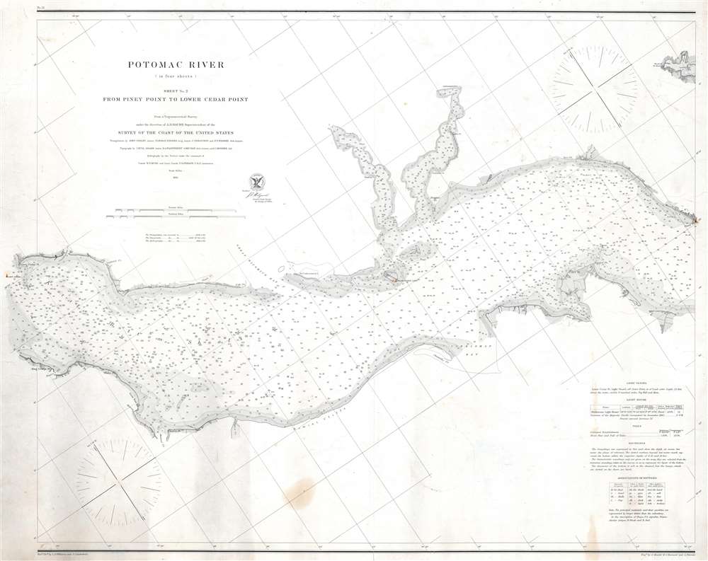
Potomac River (in four sheets) Sheet No. 2 From Piney Point to Lower Cedar Point.
1862 (dated) 23.75 x 30.5 in (60.325 x 77.47 cm) 1 : 60000
1862 (dated) 23.75 x 30.5 in (60.325 x 77.47 cm) 1 : 60000
Description
This is an 1862 U.S. Coast Survey nautical chart or maritime map of part of the Potomac River. Separating Maryland and Virginia, the map depicts from Lower Cedar Point to Piney Point. Depth soundings are indicated throughout, including in St. Clement's Bay and Breton's Bay. Points and other coastal features, including the Nomini Cliffs, are labeled. Navigational aids, such as buoys and lights, are illustrated and labeled, along with navigational hazards, including shoals and islands.
Publication History and Census
This map was drafted by Lemuel D. Williams and Adolph Lindenkohl, engraved by A. Maedel, H.S. Barnard, and A. Petersen, and published by the United States Coast Survey under the direction of Alexander D. Bache. Published as part of a set of four sheets, Sheet No. 2 is cataloged as an individual piece in OCLC as being part of the collections at George Washington University and the University of Chicago.CartographerS
The Office of the Coast Survey (1807 - present) founded in 1807 by President Thomas Jefferson and Secretary of Commerce Albert Gallatin, is the oldest scientific organization in the U.S. Federal Government. Jefferson created the "Survey of the Coast," as it was then called, in response to a need for accurate navigational charts of the new nation's coasts and harbors. The spirit of the Coast Survey was defined by its first two superintendents. The first superintendent of the Coast Survey was Swiss immigrant and West Point mathematics professor Ferdinand Hassler. Under the direction of Hassler, from 1816 to 1843, the ideological and scientific foundations for the Coast Survey were established. These included using the most advanced techniques and most sophisticated equipment as well as an unstinting attention to detail. Hassler devised a labor intensive triangulation system whereby the entire coast was divided into a series of enormous triangles. These were in turn subdivided into smaller triangulation units that were then individually surveyed. Employing this exacting technique on such a massive scale had never before been attempted. Consequently, Hassler and the Coast Survey under him developed a reputation for uncompromising dedication to the principles of accuracy and excellence. Unfortunately, despite being a masterful surveyor, Hassler was abrasive and politically unpopular, twice losing congressional funding for the Coast Survey. Nonetheless, Hassler led the Coast Survey until his death in 1843, at which time Alexander Dallas Bache, a great-grandson of Benjamin Franklin, took the helm. Bache was fully dedicated to the principles established by Hassler, but proved more politically astute and successfully lobbied Congress to liberally fund the endeavor. Under the leadership of A. D. Bache, the Coast Survey completed its most important work. Moreover, during his long tenure with the Coast Survey, from 1843 to 1865, Bache was a steadfast advocate of American science and navigation and in fact founded the American Academy of Sciences. Bache was succeeded by Benjamin Pierce who ran the Survey from 1867 to 1874. Pierce was in turn succeeded by Carlile Pollock Patterson who was Superintendent from 1874 to 1881. In 1878, under Patterson's superintendence, the U.S. Coast Survey was reorganized as the U.S. Coast and Geodetic Survey (C & GS) to accommodate topographic as well as nautical surveys. Today the Coast Survey is part of the National Oceanic and Atmospheric Administration or NOAA as the National Geodetic Survey. More by this mapmaker...
Alexander Dallas Bache (July 19, 1806 - February 17, 1867) was an American physicist, scientist and surveyor. Bache is best known in cartographic circles as the Superintendent of the U.S. Coast Survey from 1843 to 1865. Born in Philadelphia, Bache, a great grandson of the statesman and inventor Benjamin Franklin, had a varied career primarily focused on education. He toured Europe on behalf of Girard College and composed an important treatise on European Education. Later he served as president of Philadelphia's Central High School and was a professor of natural history and chemistry at the University of Pennsylvania. On the death of Ferdinand Rudolph Hassler, Bache was appointed Superintendent of the United States Coast Survey. Picking up where Hassler left off Bache presided over the Survey during its most prolific period and oversaw the mapping of most of the United States coastline. To this day his name appears on countless marine pilot books and U.S. Coast Survey nautical charts. For his work he was elected Associate Fellow of the American Academy of Arts and Sciences, a Fellow of the Royal Society of Edinburgh, and a Foreign Member of the Royal Society. Following the Civil War, Bache was elected a 3rd Class Companion of the Military Order of the Loyal Legion of the United States. He died at Newport, Rhode Island and was buried in the Congressional Cemetery in Washington, DC, where he is commemorated with a monument built by American architect Henry Hobson Richardson. Learn More...
Adolph Lindenkohl (March 6, 1833 – June 22, 1904) was a German-American cartographer and draughtsman active in the United States during the second part of the 19th century. Lindenkohl was born in Niederkaufungen, Hesse Cassel, Germany. He was educated at the Realschule and later at the Poytechnische Schule, both in Cassel. After graduating in 1852 he emigrated to the United States where, for 2 years, he taught mathematics before taking a position with the United States Coast Survey. Lindenkhol served as a topographer in the Union Army during the American Civil War, translating Coast Survey methodology and technique to land-side surveys for military use. This experience he later translated to other projects, such as the compilation of the first specific map of Alaska as part of the United States (1867). Lindenkohl was a member of the American Association for the Advancement of Science, the Washington Academy of Sciences, the Philosophical Society of Washington and the National Geographic Society. He retained his position with the Coast Survey until his death in 1904. Learn More...
Lemuel Durbin Williams (1830 - July 31, 1865) was an American draftsman and Army veteran. Williams worked as a draughtsman for the United States Coast Survey, the Northwest Boundary Survey Office, and the Treasury Department. He served as a member of the Washington Light Infantry in the years before the American Civil War, and joined the Washington Light Infantry on April 10, 1861, for a three month tour of duty. He entered as a 1st Lieutenant and was promoted to Captain before being mustered out on July 10, 1861.He married Sarah Magdeline O'Donnell on December 31, 1851, with whom he had five or six children, the historical record is unclear. He died on July 31, 1865 after suffering from 'congestion of the brain' per his obituary. Learn More...
Condition
Very good. Exhibits light wear along original centerfold. Exhibits light soiling. Closed margin tears professionally repaired on verso, one of which enters the printed image but does not extend past the border.
References
OCLC 914361938.