Digital Image: 1927 Scheuerle Pictorial Map of Glacier National Park, Montana
RecreationalGlacierNP-scheuerle-1927_d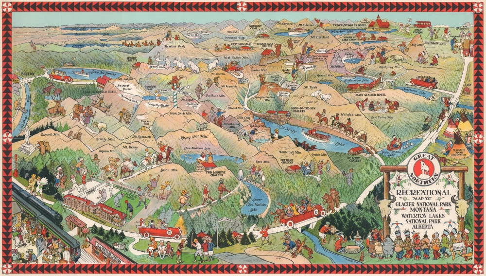

Title
Recreational Map of Glacier National Park Montana Waterton Lakes National Park Alberta.
1927 (undated) 18 x 31.9375 in (45.72 x 81.12125 cm)
1927 (undated) 18 x 31.9375 in (45.72 x 81.12125 cm)
Description
FOR THE ORIGINAL ANTIQUE MAP, WITH HISTORICAL ANALYSIS, CLICK HERE.
Digital Map Information
Geographicus maintains an archive of high-resolution rare map scans. We scan our maps at 300 DPI or higher, with newer images being 600 DPI, (either TIFF or JPEG, depending on when the scan was done) which is most cases in suitable for enlargement and printing.
Delivery
Once you purchase our digital scan service, you will receive a download link via email - usually within seconds. Digital orders are delivered as ZIP files, an industry standard file compression protocol that any computer should be able to unpack. Some of our files are very large, and can take some time to download. Most files are saved into your computer's 'Downloads' folder. All delivery is electronic. No physical product is shipped.
Credit and Scope of Use
You can use your digial image any way you want! Our digital images are unrestricted by copyright and can be used, modified, and published freely. The textual description that accompanies the original antique map is not included in the sale of digital images and remains protected by copyright. That said, we put significant care and effort into scanning and editing these maps, and we’d appreciate a credit when possible. Should you wish to credit us, please use the following credit line:
Courtesy of Geographicus Rare Antique Maps (https://www.geographicus.com).
How Large Can I Print?
In general, at 300 DPI, you should at least be able to double the size of the actual image, more so with our 600 DPI images. So, if the original was 10 x 12 inches, you can print at 20 x 24 inches, without quality loss. If your display requirements can accommodate some loss in image quality, you can make it even larger. That being said, no quality of scan will allow you to blow up at 10 x 12 inch map to wall size without significant quality loss. For more information, it is best consult a printer or reprographics specialist.
Refunds
If the high resolution image you ordered is unavailable, we will fully refund your purchase. Otherwise, digital images scans are a service, not a tangible product, and cannot be returned or refunded once the download link is used.
Cartographer
Joseph Scheuerle (March 15, 1873 - March 25, 1948) was an Austrian-American artist, illustrator, and painter. Born in Vienna, Austria, to vacationing German parents, he grew up in Stuttgart, Germany. Scheuerle immigrated to the United States with his family in 1882. The family lived in Cincinnati, Ohio, where Scheuerle's parents enrolled him in school. Once his teachers realized that he spoke almost no English, they sat him in the back of the classroom, where he spent all his time drawing. Then, he attended the Art Academy of Cincinnati and graduated in 1896. After graduation he started working for the Strobridge Lithographing Company, where he made circus and Wild West posters. In 1900 Scheuerle moved to Chicago and continued working as an illustrator. While in Chicago, Scheuerle commenced his series of portraits of Native Americans, meeting and painting the portraits of the performers traveling with Buffalo Bill's Wild West show. Scheuerle traveled to the Pine Ridge Reservation in South Dakota in 1909, where he painted the portrait of several Sioux. Among his subjects was the Lakota leader Red Cloud, who was almost ninety years old. In 1910 Scheuerle began creating work for the Great Northern Railroad, including its iconic mountain goat logo. This led to his first trip to Glacier National Park in during the summer of 1910. Sheuerle took advantage of this trip to visit other Native American reservations and paint portraits of the people he met. Over the course of his career, Scheuerle produced over two hundred portraits of Native American people. He died of a heart attack at home in South Orange, New Jersey. Scheuerle married Carolyn Lohrey in 1904, with whom he had a daughter in July 1906. More by this mapmaker...
References
Rumsey 6782.004. OCLC 38244797; 922540700. Hornsby, S. J., Picturing America: The Golden Age of Pictorial Maps, plate 107, page 190.