1817 Thomson / Hewitt Map of British Islands, including Jersey, Isles of Wight and Man
RemoteBritishIslands-thomson-1817$250.00

Title
Remote British Islands.
1817 (dated) 20 x 23.5 in (50.8 x 59.69 cm)
1817 (dated) 20 x 23.5 in (50.8 x 59.69 cm)
Description
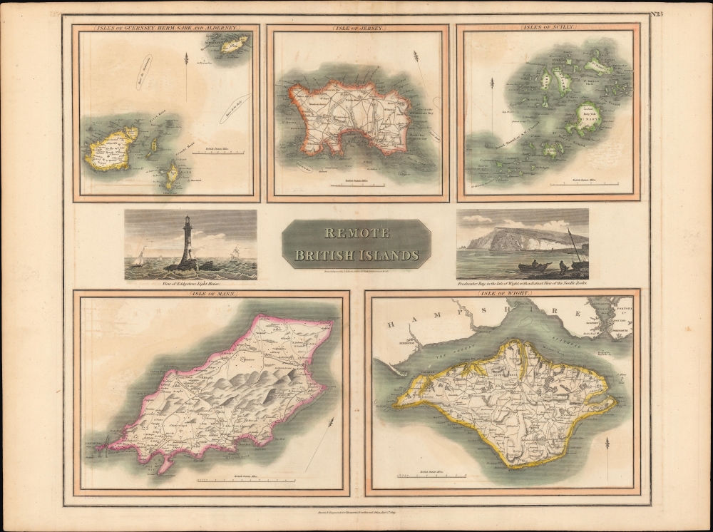
A lovely example of John Thomson's 1817 map of remote British islands, including the Isles of Wight, Man, and Jersey, with views of the Eddystone Lighthouse and Freshwater Bay on the Isle of Wight.
At center, illustrations provide views of the Eddystone Lighthouse and of Freshwater Bay off the Isle of Wight. The Eddystone Lighthouse seen here was the third of four lighthouses at that location, dating back to 1698; the original was likely the first ever offshore lighthouse.
The late 18th and 19th century brought significant change to many of the islands depicted here. Fears of French invasion - including an actual invasion of Jersey in 1781 - caused the British government to heavily fortify several of them. Meanwhile, technological improvements brought more travelers and migrants from the British mainland, altering (Anglicizing) the often deeply idiosyncratic local cultures.
A Closer Look
The sheet is composed of five maps with hand colored outlines and two views. The maps, moving clockwise from top-left, depict the islands of the Bailiwick of Guernsey in the English Channel (the Isles of Guernsey, Herm, Sark, and Alderney), Jersey, the Isles of Scilly (off the far southwestern coast of England near Cornwall), the Isle of Wight, and the Isle of Man (here as 'Mann'). Each of the maps is oriented roughly towards the north and notes towns and villages, roads, forests, areas of elevation, and coastal features such as banks and hazards.At center, illustrations provide views of the Eddystone Lighthouse and of Freshwater Bay off the Isle of Wight. The Eddystone Lighthouse seen here was the third of four lighthouses at that location, dating back to 1698; the original was likely the first ever offshore lighthouse.
The late 18th and 19th century brought significant change to many of the islands depicted here. Fears of French invasion - including an actual invasion of Jersey in 1781 - caused the British government to heavily fortify several of them. Meanwhile, technological improvements brought more travelers and migrants from the British mainland, altering (Anglicizing) the often deeply idiosyncratic local cultures.
Publication History and Census
The maps and views on this sheet were engraved by Nathaniel Rogers Hewitt for inclusion in the first edition (1817) of John Thomson's New General Atlas. It is not independently cataloged among the holdings of any institution aside from the David Rumsey Historical Map Collection, while Thomson's entire atlas is more widely distributed in institutional collections. A later edition of the sheet (1829) is independently cataloged among the holdings of the Newberry Library and the Wisconsin Historical Society (OCLC 607920871).CartographerS
John Thomson (1777 - c. 1841) was a Scottish cartographer, publisher, and bookbinder active in Edinburgh during the early part of the 19th century. Thomson apprenticed under Edinburgh bookbinder Robert Alison. After his apprenticeship, he briefly went into business with Abraham Thomson. Later, the two parted ways, John Thomson segueing into maps and Abraham Thomson taking over the bookbinding portion of the business. Thomson is generally one of the leading publishers in the Edinburgh school of cartography, which flourished from roughly 1800 to 1830. Thomson and his contemporaries (Pinkerton and Cary) redefined European cartography by abandoning typical 18th-century decorative elements such as elaborate title cartouches and fantastic beasts in favor of detail and accuracy. Thomson's principle works include Thomson's New General Atlas, published from 1814 to 1821, the New Classical and Historical Atlas of 1829, and his 1830 Atlas of Scotland. The Atlas of Scotland, a work of groundbreaking detail and dedication, would eventually bankrupt the Thomson firm in 1830, at which time their plates were sequestered by the court. The firm partially recovered in the subsequent year, allowing Thomson to reclaim his printing plates in 1831, but filed again for bankruptcy in 1835, at which time most of his printing plates were sold to A. K. Johnston and Company. There is some suggestion that he continued to work as a bookbinder until 1841. Today, Thomson maps are becoming increasingly rare as they are highly admired for their impressive size, vivid hand coloration, and superb detail. More by this mapmaker...
Nathaniel Rogers Hewitt (July 19, 1783 - 1841) was a British engraver active in London during the first half of the 19th century. Hewitt was born in London on the 19th of July 1785. His map engraving work appears as early as 1804, although it is most commonly associated with the 1812 - 1817 atlas maps of publisher John Thomson. Hewitt also worked with James Wyld, Samuel William Fores, and other map publishers of the period. In 1824, Hewitt announced plans to independently publish a series of Parish maps by subscription, and a beautifully engraved map of St. Giles in the Fields followed. The map series must not have been able to attract many followers, as Hewitt declared bankruptcy shortly after in 1826. Learn More...
Source
Thomson, J., A New General Atlas, (Edinburgh: Baldwin, Cradock, Joy) 1817.
Thomson's New General Atlas was first published in 1817 and continued to be published until about 1821. This is the first of Thomson's major cartographic works and the atlas for which is most celebrated. The New General Atlas follows in the Edinburgh School, which eschews excessive decoration in favor of a more minimalistic fact-based cartographic vision, as established by John Pinkerton, Laurie and Whittle, John Cary, and others in the previous decades. The maps are notable for their massive scale, heavy stock, elegant color work, and easy-to-read typefaces. Although the atlas stopped being published after 1821, Thomson continued to offer 'supplementary' maps that could be tipped into the atlas as late as 1830, when he declared bankruptcy. The maps in the Thomson Atlas were engraved by Thomas Clerk, William Dassauville, Nathaniel Rogers Hewitt, James Kirkwood, Robert Kirkwood, John Menzies, George Menzies, Edward Mitchell, John Moffatt, Samuel John Neele, Robert Scott, and James Wyld.
Condition
Good. Creasing along centerfold and two vertical lines to the right of centerfold towards top. Light foxing towards top. Offsetting throughout. Some wear and uneven trimming along edge.
References
Rumsey 1007.014.