1935 Norie et al Folding Map and Chart of River Thames Docks, London
RiverThamesWharfNo2-norie-1935$950.00


Title
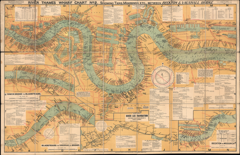
River Thames Wharf Chart No. 2 showing Tiers, Moorings Etc. between Becton and Vauxhall Bridge.
1935 (undated) 29 x 45 in (73.66 x 114.3 cm) 1 : 8111
1935 (undated) 29 x 45 in (73.66 x 114.3 cm) 1 : 8111
Description
This is a large-format folding map and nautical chart of the River Thames in London and environs, published by Imray, Laurie, Norie, and Wilson. Cataloging individual wharves and their owners in great detail, it provides a comprehensive overview of London's bustling commercial activity in the later days of British global hegemony.
Wharves, docks, basins, and other port infrastructure are indicated throughout, with their associated companies noted. On land, numerous related structures are documented, including warehouses, roads, and railways, while tunnels, bridges, hospitals, churches, and important public buildings like the Houses of Parliament are also recorded. The Royal Hospital School marked here in Greenwich is now the National Maritime Museum, while the Greenwich Observatory can be seen to its southeast. Boxes of text provide a wide range of information, such as clearance (headway) and depth of water at bridges and navigational instructions. Annotations, perhaps scratching out no longer extant features or companies, appear at the Lavendar Docks.
On the Thames, soundings are noted all along the river's length, as are a wide variety of navigational aids like lights (marked with purple ink), tiers, anchorages, rafts, buoys, hulks, moorings, stairs, and 'dolphins.' Although actual dolphins, as in the mammal, are occasionally seen in the Thames, the term here refers to groups of pilings constructed alongside docks to protect them from collisions with ships and to provide a mooring point.
A Closer Look
Coverage includes, with the insets, nearly the entire waterfront of London from Vauxhall Bridge in the west and Beckton and Woolwich in the east. The sheet is roughly divided in half, with the top half covering the river at its most commercially active point, between Tower Bridge and the Royal Docks, taking in the West India Docks, the East India Docks, the Isle of Dogs, and the Greenwich waterfront. The insets at bottom cover the river in the center of London, between Vauxhall Bridge and Tower Bridge, and a portion of the river to the east of the main map above, between Beckton and Woolwich. A west-oriented sketch plan of the River Lee Navigation, an important trading canal linking with the Thames, also appears at bottom.Wharves, docks, basins, and other port infrastructure are indicated throughout, with their associated companies noted. On land, numerous related structures are documented, including warehouses, roads, and railways, while tunnels, bridges, hospitals, churches, and important public buildings like the Houses of Parliament are also recorded. The Royal Hospital School marked here in Greenwich is now the National Maritime Museum, while the Greenwich Observatory can be seen to its southeast. Boxes of text provide a wide range of information, such as clearance (headway) and depth of water at bridges and navigational instructions. Annotations, perhaps scratching out no longer extant features or companies, appear at the Lavendar Docks.
On the Thames, soundings are noted all along the river's length, as are a wide variety of navigational aids like lights (marked with purple ink), tiers, anchorages, rafts, buoys, hulks, moorings, stairs, and 'dolphins.' Although actual dolphins, as in the mammal, are occasionally seen in the Thames, the term here refers to groups of pilings constructed alongside docks to protect them from collisions with ships and to provide a mooring point.
Historical Context
This stretch of the Thames was the center of global trade in the 19th century. By the time this map was produced, London had some strong competition elsewhere, namely in the port facilities around New York City, but the city's docks hardly fell into disuse. In fact, the late 19th and early 20th century saw significant upgrades and modernization, starting with the 'Royal Docks' (Victoria Docks, Albert Docks, and King George V Docks), which became the busiest docks along the Thames by the early 20th century, specializing in the transport of foodstuffs, explaining the large number of grain silos and refrigerated warehouses alongside them here. Also, in 1908, Parliament passed the Port of London Act, which merged several major dock companies and the Thames Conservancy to have a single body overseeing management of the river and its docks, wharves, piers, and other infrastructure. The new Port of London Authority set about deepening the river and investing in the modernization of infrastructure, so that by the 1930s, when this map was published, the river's dock capacity peaked at 713 acres.Publication History and Census
This map was prepared and published by Imray, Laurie, Norie, and Wilson. It is undated, but the companies included, and other details are consistent with a date in the Interwar Period, most likely the 1930s. We do not locate any examples of maps with this exact title in the OCLC, though two maps, held by the British Library and the University of Wisconsin-Milwaukee, respectively, have highly similar titles, sizes, inset maps, and notation based on the catalog descriptions.CartographerS
John William Norie (June 3, 1772 - December 24, 1843) was a British teacher of navigation, hydrographer, chart maker, and publisher of maritime manuals active in London, England in the late 18th and early 19th centuries. Norie was born in Wapping, London, an area long associated with the maritime sciences. Norie's career as a chart maker commenced under the tutelage of William Heather, a prominent purveyor and publisher of nautical charts, pilot books, and navigational tools who took over the firm of Mount and Page in 1765. Heather and Norie were likely acquainted through John Hamilton Moore, another important chart maker with whom both seem to have been associated early in their careers. Heather hired Norie to teach basic navigation at his shop at 157 Leadenhall Street. Under Heather Norie also distinguished himself as a draftsman, completing many of the early charts associated with the Heather firm. When Heather died in 1812 John Norie partnered with George Wilson, a moneyed 'man about town' with little experience in the maritime trades, to acquire the map and chart business at 9500 British Pounds. It proved a good deal for Norie, who retained all copyright privileges and drew 1/4 quarter share of business profits, as well an impressive quarterly salary and, for doing all of the work, 1/3rd of Wilson's share. The firm, referred to as the 'Naval Warehouse' quickly acquired a reputation for quality navigational materials and became a favorite of merchant seamen. It was even referenced in Charles Dickens' classic novel Dombey and Son. In 1819, Norie and Wilson acquired the failing chart business of David Steel, which significantly increased the size, though not quality, of their chart catalogue. With the rise of the British Admiralty and its own maritime chart productions, the business of "Chart Purveyor" in London dramatically changed. Admiralty charts and pilot books, designed for military use, were offered through established intermediaries, like Norie, at bargain prices. Most chart makers of the period found it profitable to use the highly technical Admiralty charts to update their own more decorative vernacular charts. For a brief time this practice proved exceptionally profitable but eventually began to draw criticism. Nonetheless, Norie retired to Edinburgh in 1840 and died a wealthy man in 1843. In 1840 the business passed to a nephew of George Wilson, Charles Wilson, who renamed the firm "Norie & Wilson". William Heather Norie, J. W. Norie's own son, produced few charts, instead pursuing a career in the legal field. Norie & Wilson merged with James Imray's prosperous chart business in 1899, becoming Imray, Laurie, Norie & Wilson, a profitable concern that remains active in the maritime charting industry. More by this mapmaker...
James Imray (May 16, 1803 - November 15, 1870) was a Scottish hydrographer and stationer active in London during the middle to latter part of the 19th century. Imray is best known as a the largest and most prominent producer of blue-back charts, a kind of nautical chart popular from about 1750 to 1920 and named for its distinctive blue paper backing (although not all charts that may be called "blue-backs" actually have a blue backing). Unlike government charts issued by the British Admiralty, U.S. Coast Survey, and other similar organizations, Imray's charts were a private profit based venture and not generally the result of unique survey work. Rather, Imray's charts were judicious and beautiful composites based upon pre-existing charts (some dating to the 17th century) and new information gleaned from governmental as well as commercial pilots and navigators. Imray was born in Spitalfields, England, the eldest son of a Jacobite dyer also named James. Imray did not follow his father profession, instead apprenticing to William Lukyn, a stationer. He established himself as a bookseller and bookbinder at 116 Minories Street, where he shared offices with the nautical chart publisher Robert Blanchford. In 1836 Imray signed on as a full partner in Blanchford's enterprise, christening themselves Blanchford & Imray. At this time the Blanchford firm lagged far behind competing chart publishers Norie and Laruie, nevertheless, with the injection of Imray's marketing savvy the firm began a long rise. James Imray bought out Blanchford's share in 1846, becoming the sole proprietor of the chart house, publishing under the imprint of James Imray. Relocating in 1850 to larger offices at 102 Minories, Imray was well on track to become the most prominent chart publisher in London. In 1854, when Imray's 25 year old son, James Frederick Imray, joined as a full partner, the firm again changed its imprint, this time to James Imray and Son. The elder Imray was a master of marketing and was quick to respond to trade shifts and historic events. Many of his most successful charts were targeted to specific trade routes, for example, he issued charts entitled "Cotton Ports of Georgia" and "Rice Ports of India". Other charts emerged quickly following such events as the 1849 California Gold Rush. Imray's rise also coincided with the development of governmental mapping organizations such as the Admiralty and the U.S. Coast Survey, whose work he appropriated and rebranded in practical format familiar to navigators. Imray's death in 1870 marked a major transition in the firm's output and began its decline. Though Imray's son, James Frederick, excelled at authoring pilot books he had little experience with charts and issued few new publications. Most James Frederick Imray publications issued from 1870 to 1899 were either revisions of earlier maps prepared by his father or copies of British Admiralty charts. Charts from this period are recognizable as being less decorative than the elder Imray's charts following the stylistic conventions established by the Admiralty. The Admiralty itself at the same time began to rise in prominence, issuing its own official charts that were both cheaper and more up to date than those offered by private enterprises. By the end of the century the firm was well in decline and, in 1899 "James Imray and Son" amalgamated with the similarly suffering "Norie and Wilson", which was itself acquired by Laurie in 1904. Today it continues to publish maritime charts as "Imray, Laurie, Norie and Wilson". Learn More...
Richard Holmes Laurie (December 2, 1777 - January 19, 1858) was a British map and chart publisher and seller. Born in London to publisher Robert Laurie and his wife Esther Jouret, R. H. Laurie took over his father's share of the Laurie and Whittle publishing firm upon his father's retirement in 1812 and began trading as Whittle and Laurie. After Whittle died in 1818, Laurie continued the business by himself, trading under the imprint R. H. Laurie. During the 1820s and 1830s, Laurie expanded the nautical chart business until he was overtaken by Admiralty charts. Laurie married Susan Ann Coates on February 6, 1814 and later married Mary Ann Dennison on October 15, 1833. He left his business and all his property in trust for his two surviving daughters (both of whom were minors) with his principal engraver, Alexander George Findlay. Findlay continued the business in Laurie's name after acquiring its equity from his daughters. Learn More...
Charles Wilson (1807 - May 16, 1882) was a British-Indian publisher of nautical charts and maps based in London, England. Born in Lucknow, India, Wilson was the son Lieutenant-Colonel William Wilson and his wife Hoosainee Begum, an Indian princess, who was the daughter of the Nizam of Ashrafabad. Wilson was educated in England and worked in the wine trade before joining the Norie firm in 1838. Norie had already partnered with another Wilson, George, who was a nephew to Charles. When Norie retired in 1840, Charles Wilson took over the firm publishing as 'Charles Wilson (Late J.W. Noire and Wilson)'. He married Jane Arabella Bingle on July 1, 1846. Wilson died in 1882 passing the firm on to his sons, George and William Wilson. The brothers merged the firm with that of J. Imray and Sons in 1899 and, as Imray, Laurie, Norie and Wilson Ltd., they continue to publish to the present day. Learn More...
Condition
Very good. Dissected and mounted on original linen. Minor splits to linen.
References
OCLC 55226005 (similar but not identical), 557676998 (similar but not identical).