Digital Image: 1848 Belcher Nautical Map of the Ryukyu Islands and the Korea Strait
RyukyuJeju-belcher-1848_d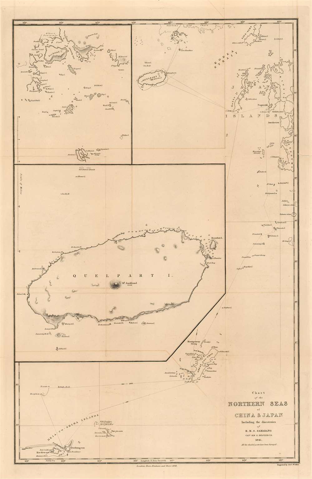

Title
Chart of the Northern Seas of China and Japan Including the Discoveries of H. M. S. Samarang Captn, Sir E, Belcher C.B. 1845. All the shaded parts have been Surveyed.
1848 (dated) 12 x 18.5 in (30.48 x 46.99 cm) 1 : 2600000
1848 (dated) 12 x 18.5 in (30.48 x 46.99 cm) 1 : 2600000
Description
FOR THE ORIGINAL ANTIQUE MAP, WITH HISTORICAL ANALYSIS, CLICK HERE.
Digital Map Information
Geographicus maintains an archive of high-resolution rare map scans. We scan our maps at 300 DPI or higher, with newer images being 600 DPI, (either TIFF or JPEG, depending on when the scan was done) which is most cases in suitable for enlargement and printing.
Delivery
Once you purchase our digital scan service, you will receive a download link via email - usually within seconds. Digital orders are delivered as ZIP files, an industry standard file compression protocol that any computer should be able to unpack. Some of our files are very large, and can take some time to download. Most files are saved into your computer's 'Downloads' folder. All delivery is electronic. No physical product is shipped.
Credit and Scope of Use
You can use your digial image any way you want! Our digital images are unrestricted by copyright and can be used, modified, and published freely. The textual description that accompanies the original antique map is not included in the sale of digital images and remains protected by copyright. That said, we put significant care and effort into scanning and editing these maps, and we’d appreciate a credit when possible. Should you wish to credit us, please use the following credit line:
Courtesy of Geographicus Rare Antique Maps (https://www.geographicus.com).
How Large Can I Print?
In general, at 300 DPI, you should at least be able to double the size of the actual image, more so with our 600 DPI images. So, if the original was 10 x 12 inches, you can print at 20 x 24 inches, without quality loss. If your display requirements can accommodate some loss in image quality, you can make it even larger. That being said, no quality of scan will allow you to blow up at 10 x 12 inch map to wall size without significant quality loss. For more information, it is best consult a printer or reprographics specialist.
Refunds
If the high resolution image you ordered is unavailable, we will fully refund your purchase. Otherwise, digital images scans are a service, not a tangible product, and cannot be returned or refunded once the download link is used.
Cartographer
Sir Edward Belcher (February 27, 1799 – March 18, 1877) was a British naval officer, scientist, explorer, and marine surveyor active in the middle part of the 19th century. Belcher was born in Halifax, Nova Scotia, to a proud seafaring family. He entered the Royal Navy in 1812, at just 13 years of age. Thirteen years later, in 1825, he was assigned as official surveyor to the Frederick William Beechey expedition to the Pacific and the Bering Strait. By 1836 he was in command of his own surveying (and bombing) ship, the H.M.S. Sulphur in western Africa and the Pacific coast of South America. The Sulphur was ordered back to England via the Trans-Pacific Route in 1839. On the way, he was delayed and reassigned to China to take part in the First Opium War (1839 – 1842). During this period, on January 26 of 1841, he landed on Possession Point on the northern shore of Hong Kong Island. During this visit he made the influential first British survey of Hong Kong Harbor. On returning to England he was Knighted for his services and reassigned to the HMS Samarang to complete survey work throughout the East Indies, but most specifically in the Philippines. In 1852 he commanded the last and largest Admiralty expedition in search of the lost Arctic Explorer Sir John Franklin. The expedition had five ships, four of which were lost to the Arctic ice. Like all British naval officers who lose a ship, he was court-martialed on his return to England. Although exonerated, he never received another command. He died in London at the age of 78. Belcher is commemorated in Hong Kong through Belcher's Street, Belcher Bay and The Belcher's in Kennedy Town. His name is also commemorated in the Belcher Islands, in the Canadian Arctic. He is also commemorated with a plaque in the Admiralty Garden. Following his last active service, he was appointed Knight Commander of the Order of the Bath in 1867 and an admiral in 1872. More by this mapmaker...
Source
Belcher, Captain Sir Edward. Narrative of the voyage of H.M.S. Samarang, during the years 1843-46 (London : Reeve, Benham, and Reeve) 1848.
References
OCLC 793035200.