This item has been sold, but you can get on the Waitlist to be notified if another example becomes available, or purchase a digital scan.
1848 Belcher Nautical Map of the Ryukyu Islands and the Korea Strait
RyukyuJeju-belcher-1848$750.00

Title
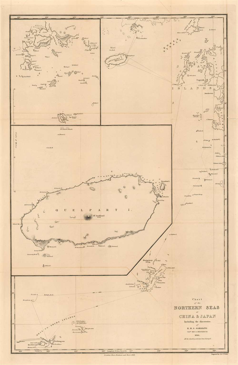
Chart of the Northern Seas of China and Japan Including the Discoveries of H. M. S. Samarang Captn, Sir E, Belcher C.B. 1845. All the shaded parts have been Surveyed.
1848 (dated) 12 x 18.5 in (30.48 x 46.99 cm) 1 : 2600000
1848 (dated) 12 x 18.5 in (30.48 x 46.99 cm) 1 : 2600000
Description
This is an extremely rare 1848 Edward Belcher nautical map of the East China Sea, presenting the first scientific survey of the Ryukyu Islands and Okinawa (沖縄本島), Jeju Island (제주도) and Goheung Island (거금도). It was the result of the 1843-46 voyage of Captain Sir Edward Belcher aboard H.M.S. Samarang, which was noted and celebrated not only for thoroughly surveying the islands but also for conducting detailed socio-political and natural studies of them. Belcher was already a famous man prior to this expedition, having been knighted for his service in the First Opium War and having produced the first British survey of Hong Kong harbor. Belcher's expedition aboard the Samarang was explicitly intended to survey the approaches to the five Chinese ports that had been opened to the British in the 1842 Treaty of Nanking, which marked the end of the war.
The Path of H.M.S. Samarang: Ryukyu Islands
Belcher's entire voyage of discovery in the East China Sea is captured within the bounds of this chart. H.M.S. Samarang is shown entering and leaving the survey area in the southwest corner of the chart, stopping at 'Port Haddington' on Yaeyama island, here named 'Pa-tchung-san.' From there, the ship's track strikes north to the Senkaku Islands before heading east to 'Great Loo-Choo,' which is Okinawa Island. In 1787 La Perouse had charted the island of Kume but only having seen the island, not visited; and he had not charted the main island of Okinawa at all.Jeju Island
Belcher then sailed north to Goto Island. From there, he turned west to circumnavigate Jeju Island, (Quelpart, on the chart) making a sufficiently detailed survey of the northern coast so as to require the large, detailed inset chart dominating this piece. This represents the first accurate charting of Jeju, La Perouse's charting again having only been partial, and based on a sighting and not a survey.Goheung and Geomundo
Belcher went further north to chart an archipelago on the southern Korean coast, chiefly Goheung Island,(which Belcher named 'Auckland Island' on this chart) and Geomundo (거문도) (which he named Port Hamilton). The detailed survey from this part of the voyage is recorded on the chart's second inset.The Return Trip
H.M.S. Samarang's course backtracked to Japan, stopping at Nagasaki before returning to Okinawa; Belcher's route runs through the northern arc of the Ryukyu islands running from Kagoshima to Okinawa, thereafter returning via Yaeyama.Publication History and Census
We see no examples of this map having appeared on the market. There is a listing for the map in OCLC but no institutional collections are cited there. The map was included in Belcher's account of the voyage, which is well represented in institutional collections.Cartographer
Sir Edward Belcher (February 27, 1799 – March 18, 1877) was a British naval officer, scientist, explorer, and marine surveyor active in the middle part of the 19th century. Belcher was born in Halifax, Nova Scotia, to a proud seafaring family. He entered the Royal Navy in 1812, at just 13 years of age. Thirteen years later, in 1825, he was assigned as official surveyor to the Frederick William Beechey expedition to the Pacific and the Bering Strait. By 1836 he was in command of his own surveying (and bombing) ship, the H.M.S. Sulphur in western Africa and the Pacific coast of South America. The Sulphur was ordered back to England via the Trans-Pacific Route in 1839. On the way, he was delayed and reassigned to China to take part in the First Opium War (1839 – 1842). During this period, on January 26 of 1841, he landed on Possession Point on the northern shore of Hong Kong Island. During this visit he made the influential first British survey of Hong Kong Harbor. On returning to England he was Knighted for his services and reassigned to the HMS Samarang to complete survey work throughout the East Indies, but most specifically in the Philippines. In 1852 he commanded the last and largest Admiralty expedition in search of the lost Arctic Explorer Sir John Franklin. The expedition had five ships, four of which were lost to the Arctic ice. Like all British naval officers who lose a ship, he was court-martialed on his return to England. Although exonerated, he never received another command. He died in London at the age of 78. Belcher is commemorated in Hong Kong through Belcher's Street, Belcher Bay and The Belcher's in Kennedy Town. His name is also commemorated in the Belcher Islands, in the Canadian Arctic. He is also commemorated with a plaque in the Admiralty Garden. Following his last active service, he was appointed Knight Commander of the Order of the Bath in 1867 and an admiral in 1872. More by this mapmaker...
Source
Belcher, Captain Sir Edward. Narrative of the voyage of H.M.S. Samarang, during the years 1843-46 (London : Reeve, Benham, and Reeve) 1848.
Condition
Very good. Few minor mends at folds. Faint offsetting.
References
OCLC 793035200.