1958 British Admiralty Nautical Map of St. Croix, U.S. Virgin Islands
SaintCroix-admiralty-1958$500.00


Title
West Indies. St. Croix (Santa Cruz).
1958 (dated) 26.5 x 39.75 in (67.31 x 100.965 cm) 1 : 58000
1958 (dated) 26.5 x 39.75 in (67.31 x 100.965 cm) 1 : 58000
Description
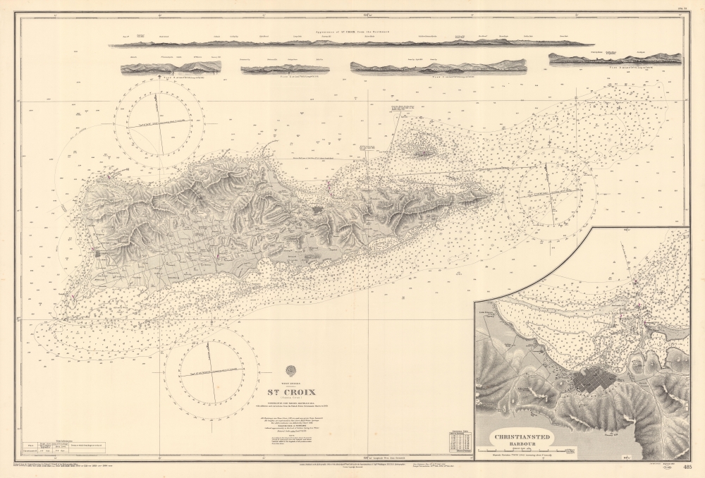
This is a beautiful 1903 British Admiralty nautical chart or maritime map depicting the island of Saint Croix (Santa Cruz) in the U.S. Virgin Islands. Unlike most Admiralty charts, a surprising level of inland detail is presented here. Both Frederiksted and Christiansted are labeled and illustrated with streets and city blocks. Homesteads across the island are identified as well, many of which are marked by windmills. Major roads are also included. Myriad depth soundings are noted all along the island's coast and extend east of the island to Lang Bank. A detailed inset map of Christiansted city and harbor is situated in the lower right corner. Five coastal views are included along the top border.
Publication History and Census
This map was created by the British Admiralty and originally published in 1858. As is common with nautical charts, corrections were made and subsequent editions were published, with the present example dating from 1903. No examples of the present chart are catalogued in the OCLC and we have been unable to isolate previous market history.Cartographer
The British Admiralty Office (1795 - Present) or the United Kingdom Hydrographic Office refers to the Branch of the English government that is responsible for the command of the British Navy. In 1795 King George III created the United Kingdom Hydrographic Office, known in short as the U.K.H.O., to provide top notch nautical charts to the vast Royal Navy. Prior the founding of the Admiralty the surveying and creation of nautical charts was primarily a commercial venture wherein the cartographer himself, more of than not, actually financed the printing of his own material. The great navigator Cook himself is known to have scrambled for funds to publish his own seminal charts - the most important and advanced of the period. The system of privately funded nautical mapping and publishing left vast portions of the world uncharted and many excellent charts unpublished. King George III, responding significant loss in trade revenue related to shipwrecks and delay due to poor charts, recognized the need for an institutionalized government sponsored cartographic agency - the Admiralty. The first head of the Admiralty, a position known as Hydrographer, was the important cartographer Alexander Dalrymple. Dalrymple started by organizing and cataloging obtainable charts before initiating the laborious process of updating them and filling in the blanks. The first official Admiralty Chart appeared in 1800 and detailed Quiberon Bay in Brittany. By 1808 the position of Hydrographer fell to Captain Thomas Hurd. Hurd advocated the sale of Admiralty charts to the general public and, by the time he retired in 1829, had issued and published some 736 charts. Stewardship of the organization then passed to Rear Admiral Sir Francis Beaufort. It was under Beaufort's administration that the Admiralty truly developed as a "chart making" as opposed to a "chart cataloging" institution. Beaufort held his post from 1829 to 1854. In his 25 years at the Admiralty Beaufort created nearly 1500 new charts and sponsored countless surveying and scientific expeditions - including the 1831 to 1836 voyage of the H.M.S. Beagle. By 1855 the Admiralty's chart catalog listed some 1,981 charts. More by this mapmaker...
Condition
Very good.