Digital Image: 1915 Chevalier Map of San Francisco, California
SanFrancisco-chevalier-1915_d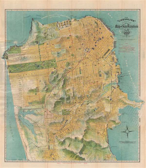

Title
The 'Chevalier' Commercial Pictorial and Tourist Map of San Francisco.
1915 (dated) 25 x 23.5 in (63.5 x 59.69 cm) 1 : 24000
1915 (dated) 25 x 23.5 in (63.5 x 59.69 cm) 1 : 24000
Description
FOR THE ORIGINAL ANTIQUE MAP, WITH HISTORICAL ANALYSIS, CLICK HERE.
Digital Map Information
Geographicus maintains an archive of high-resolution rare map scans. We scan our maps at 300 DPI or higher, with newer images being 600 DPI, (either TIFF or JPEG, depending on when the scan was done) which is most cases in suitable for enlargement and printing.
Delivery
Once you purchase our digital scan service, you will receive a download link via email - usually within seconds. Digital orders are delivered as ZIP files, an industry standard file compression protocol that any computer should be able to unpack. Some of our files are very large, and can take some time to download. Most files are saved into your computer's 'Downloads' folder. All delivery is electronic. No physical product is shipped.
Credit and Scope of Use
You can use your digial image any way you want! Our digital images are unrestricted by copyright and can be used, modified, and published freely. The textual description that accompanies the original antique map is not included in the sale of digital images and remains protected by copyright. That said, we put significant care and effort into scanning and editing these maps, and we’d appreciate a credit when possible. Should you wish to credit us, please use the following credit line:
Courtesy of Geographicus Rare Antique Maps (https://www.geographicus.com).
How Large Can I Print?
In general, at 300 DPI, you should at least be able to double the size of the actual image, more so with our 600 DPI images. So, if the original was 10 x 12 inches, you can print at 20 x 24 inches, without quality loss. If your display requirements can accommodate some loss in image quality, you can make it even larger. That being said, no quality of scan will allow you to blow up at 10 x 12 inch map to wall size without significant quality loss. For more information, it is best consult a printer or reprographics specialist.
Refunds
If the high resolution image you ordered is unavailable, we will fully refund your purchase. Otherwise, digital images scans are a service, not a tangible product, and cannot be returned or refunded once the download link is used.
Cartographer
August Chevalier (1871 – November 29, 1934) was a French-born American lithographer living and working in San Francisco, California. He came to the United States in 1890. Nothing is known about his early life and education, but he appears to have made his name with the publication of his 1904 work 'The Commercial, Pictorial and Tourist map of San Francisco': Chevalier's wife, Josephine, came to America from France that year, so perhaps the publication of his first map provided the means for bringing her to join him. Chevalier would go on to produce half a dozen plans of his home city, of which his magnificent 1912 topographical map of San Francisco known as 'The Chevalier' is best known. In 1931 he produced a series of 'Aero-Map-Views' of various regions of California, all of which appear to be quite rare. More by this mapmaker...
References
Rumsey 5865.002. OCLC 28943362, 953568824.