1871 Little Map of Land for Sale in the San Joaquin Valley, California
SanJoaquinValley-little-1871$750.00

Title
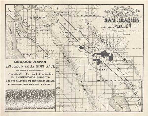
John T. Little's Map of San Joaquin Valley.
1871 (undated) 9 x 11.5 in (22.86 x 29.21 cm) 1 : 1200000
1871 (undated) 9 x 11.5 in (22.86 x 29.21 cm) 1 : 1200000
Description
This is an 1871 John T. Little promotional real estate map of the San Joaquin Valley, in California east of San Francisco Bay. The map depicts the region from the Pacific Ocean to the Yosemite Valley and from Marin County and San Joaquin, California to Tulare Lake. Created as an advertisement for Little's real estate business, the grid of the Public Land Survey System is overlaid on the map, allowing for interested clients to easily identify the particular township they would like to acquire. The township (one square in the grid) was created as the measure of the Public Land Survey System, which was first widely implemented to survey the Northwest Ordinance. The System set up a method for the systematic surveying and mapping of any territory gained by the United States, which allowed for peaceful and orderly westward expansion. The towns of Merced and Fresno are situated in the heart of the San Joaquin Valley and are illustrated here. Both the San Joaquin Valley Railroad and the Stockton and Visalia Railroad are also illustrated in detail, as a way of enticing potential buyers; close proximity to railroads would greatly reduce potential transport costs of getting any crops to market. Little sales pitch is included in the lower left corner, where he fawns over the superb quality of the land and the likelihood of high yields and profits.
This map was created by John T. Little and lithographed by Britton and Rey of San Francisco in 1871.
This map was created by John T. Little and lithographed by Britton and Rey of San Francisco in 1871.
CartographerS
John T. Little (fl. c. 1849 - 1860) was an American businessman who found success in California. Little arrived in California in 1849, at the height of the Gold Rush, an settled in Coloma, where he opened on the first general stores on the north side of the American River. On November 8, 1849, the first 'official' post office in El Dorado County, California, was established in his store. Little was appointed postmaster, a position he held until 1851, when the title was given to Stephen S. Brooks. Little proved himself to be an adept businessman. He operated the first ferry service across the American River, creating a connection between the mining camps on the south side and his general store on the north side. In 1850, Little partnered with Ed Raum and built the first wagon bridge across the American and charged a toll for each crossing. The partners recouped their investment within three months. Eventually, Little moved to San Francisco, where he became a real estate broker and moneylender, operating his business from Montgomery Street. More by this mapmaker...
Britton and Rey (1852 - 1906) was a lithographic firm based in San Francisco founded by Joseph Britton (1825 - 1901) and Jacques Joseph Rey (1820 - 1892). The leading firm in the area during the second half of the 19th century, Britton and Rey eventually earned the reputation of being the western Currier and Ives. They published both large-format and postcard views of California, as well as with stock certificates, stationery, and maps. Within the partnership, Rey was the artist and Britton the principal lithographer. Britton was also principally concerned with the business aspects of the firm. The firm also printed lithographs by other artists, including Thomas Almond Ayres (1816 - 1858), George Holbrook Baker (1824 - 1906), Charles Christian Nahl (1818 - 1878), and Frederick August Wenderoth (1819 - 1884). After Rey's death in 1892 and Britton's subsequent retirement, the firm passed to Rey's son, Valentine J. A. Rey, who ran the firm until at least the 1906 San Francisco earthquake and fire. A. Carlisle and Company, another San Francisco printer, acquired the remains of the Britton and Rey firm in 1916. For more information about Joseph Britton and Jacques Joseph Rey, please reference their individual biographies included in our cartographer database. Learn More...
Condition
Very good. Even overall toning. Backed on linen.