Digital Image: 1855 Gilliss Panoramic View of Santiago, Chile From Santa Lucia Hill
Santiago-gilliss-1855_d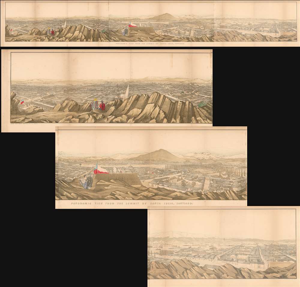

Title
Panoramic View from the Summit of Santa Lucia, Santiago.
1855 (undated) 9.75 x 67.5 in (24.765 x 171.45 cm)
1855 (undated) 9.75 x 67.5 in (24.765 x 171.45 cm)
Description
FOR THE ORIGINAL ANTIQUE MAP, WITH HISTORICAL ANALYSIS, CLICK HERE.
Digital Map Information
Geographicus maintains an archive of high-resolution rare map scans. We scan our maps at 300 DPI or higher, with newer images being 600 DPI, (either TIFF or JPEG, depending on when the scan was done) which is most cases in suitable for enlargement and printing.
Delivery
Once you purchase our digital scan service, you will receive a download link via email - usually within seconds. Digital orders are delivered as ZIP files, an industry standard file compression protocol that any computer should be able to unpack. Some of our files are very large, and can take some time to download. Most files are saved into your computer's 'Downloads' folder. All delivery is electronic. No physical product is shipped.
Credit and Scope of Use
You can use your digial image any way you want! Our digital images are unrestricted by copyright and can be used, modified, and published freely. The textual description that accompanies the original antique map is not included in the sale of digital images and remains protected by copyright. That said, we put significant care and effort into scanning and editing these maps, and we’d appreciate a credit when possible. Should you wish to credit us, please use the following credit line:
Courtesy of Geographicus Rare Antique Maps (https://www.geographicus.com).
How Large Can I Print?
In general, at 300 DPI, you should at least be able to double the size of the actual image, more so with our 600 DPI images. So, if the original was 10 x 12 inches, you can print at 20 x 24 inches, without quality loss. If your display requirements can accommodate some loss in image quality, you can make it even larger. That being said, no quality of scan will allow you to blow up at 10 x 12 inch map to wall size without significant quality loss. For more information, it is best consult a printer or reprographics specialist.
Refunds
If the high resolution image you ordered is unavailable, we will fully refund your purchase. Otherwise, digital images scans are a service, not a tangible product, and cannot be returned or refunded once the download link is used.
Cartographer
James Melville Gilliss, (September 6, 1811 - February 9, 1865) was an American astronomer and naval officer, and founder of the United States Naval Observatory. He was born in Georgetown, his father a federal employee. In 1827 he joined the navy; upon passing midshipman in 1833 he took leave to began studies at the University of Virginia, but poor health drove him to leave after six months. After completing his studies in Paris, he was recalled to Washington to serve as an assistant at Charles Wilkes' Depot of Charts and Instruments in 1836. The abundance of astronomical devices available at the depot afforded Gilliss the opportunity to practice the astronomical observations necessary to determine the accuracy of the Navy's chronometers, at which he proved to excel. He achieved promotion to the head of the depot in 1838. In 1846 he published Astronomical Observations made at the Naval Observatory, Washington, a listing of 1,248 stars and the first star catalog published in the United States. Gilliss is celebrated for his personal establishment of the U.S. Naval Observatory, the first national observatory in the United States. In 1848 he obtained funding for, and personally headed the 1849-1852 naval astronomical expedition to Chile in order to more precisely measure the solar parallax. The expedition completed the planned astronomical observations as well as valuable observations of the earth's magnetism, earthquakes, geography, Chilean politics and natural science. The specimens brought back from Chile formed the earliest part of the Smithsonian collection from Latin America. Gilliss later led two expeditions to observe eclipses - Peru in 1858, and Washington Territory in 1860. Gilliss was placed in charge of the Naval observatory in 1861 and became a founding member of the National Academy of Sciences. More by this mapmaker...
Source
Gilliss, J. M., The U.S. Naval Astronomical Expedition to the southern hemisphere, during the years 1849-'50-'51-'52, (Washington D. C.: Nicholson) 1855.
References
OCLC 495033501.