Digital Image: 1915 China Publishing Pictorial View Map of Shanghai
Shanghai-chinapublishing-1915_d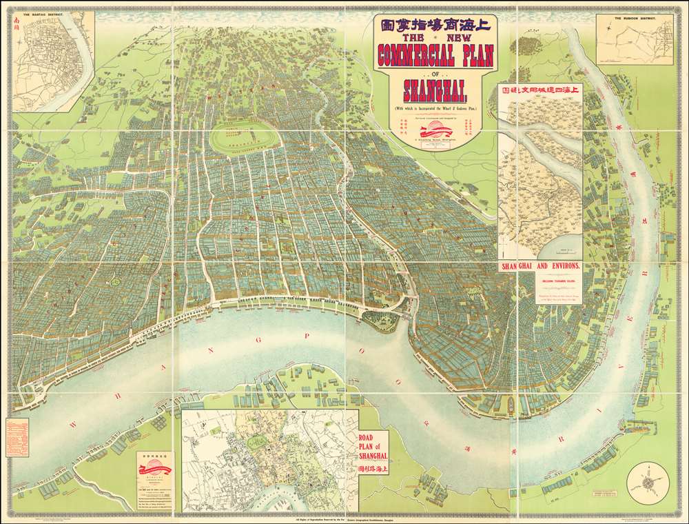

Title
The New Commercial Plan of Shanghai (with which is incorporated the Wharf and Godown Plan). Surveyed, constructed and designed by the Far Eastern Geographical Establishment 6 Kiukiang Road Shanghai.
1915 (dated) 63 x 83 in (160.02 x 210.82 cm)
1915 (dated) 63 x 83 in (160.02 x 210.82 cm)
Description
FOR THE ORIGINAL ANTIQUE MAP, WITH HISTORICAL ANALYSIS, CLICK HERE.
Digital Map Information
Geographicus maintains an archive of high-resolution rare map scans. We scan our maps at 300 DPI or higher, with newer images being 600 DPI, (either TIFF or JPEG, depending on when the scan was done) which is most cases in suitable for enlargement and printing.
Delivery
Once you purchase our digital scan service, you will receive a download link via email - usually within seconds. Digital orders are delivered as ZIP files, an industry standard file compression protocol that any computer should be able to unpack. Some of our files are very large, and can take some time to download. Most files are saved into your computer's 'Downloads' folder. All delivery is electronic. No physical product is shipped.
Credit and Scope of Use
You can use your digial image any way you want! Our digital images are unrestricted by copyright and can be used, modified, and published freely. The textual description that accompanies the original antique map is not included in the sale of digital images and remains protected by copyright. That said, we put significant care and effort into scanning and editing these maps, and we’d appreciate a credit when possible. Should you wish to credit us, please use the following credit line:
Courtesy of Geographicus Rare Antique Maps (https://www.geographicus.com).
How Large Can I Print?
In general, at 300 DPI, you should at least be able to double the size of the actual image, more so with our 600 DPI images. So, if the original was 10 x 12 inches, you can print at 20 x 24 inches, without quality loss. If your display requirements can accommodate some loss in image quality, you can make it even larger. That being said, no quality of scan will allow you to blow up at 10 x 12 inch map to wall size without significant quality loss. For more information, it is best consult a printer or reprographics specialist.
Refunds
If the high resolution image you ordered is unavailable, we will fully refund your purchase. Otherwise, digital images scans are a service, not a tangible product, and cannot be returned or refunded once the download link is used.
Cartographer
Edwin John Dingle (April 6, 1881 - January 28, 1972) was an English journalist, publisher, author, and mystical guru. Dingle was born in Cornwall but orphaned at just 9. He studied to become a journalist, moving to Singapore in 1900 to cover the Far East. He traveled extensively in China and was involved with the early days of publishing in Shanghai. From Shanghai and Singapore, he also published several early maps of China, Shanghai, the The New Atlas and Commercial Gazetteer of China, and several books on the history of China. In 1910, Dingle traveled to Tibet, where he reportedly studied under a Tibetan 'spiritual master' and Lama. On his return from Tibet, he witnessed the 1911 Xinhai Revolution, observing events in both Wuhan and Shanghai, as well as the brutal attacks on Hankou and Hanyang. After some 21 years in China, Dingle relocated to Oakland California, where he lived in seclusion meditating and practicing his own version of Pranayama in pursuit of mystical powers, extrasensory perception, and spiritual development. There Dingle founded the Institute of Mentalphysics in 1933-34, styling himself President and Preceptor Emeritus. The institute was well financed and hired the famed architect Frank Lloyd Wright to design a near 400-acre campus in Joshua Tree. At the institute he called himself by his adopted Chinese name, Ding Le Mei (丁乐梅). Dingle died in 1972 in California. More by this mapmaker...
References
OCLC 62677469.