This item has been sold, but you can get on the Waitlist to be notified if another example becomes available, or purchase a digital scan.
1915 China Publishing Pictorial View Map of Shanghai
Shanghai-chinapublishing-1915$25,000.00

Title
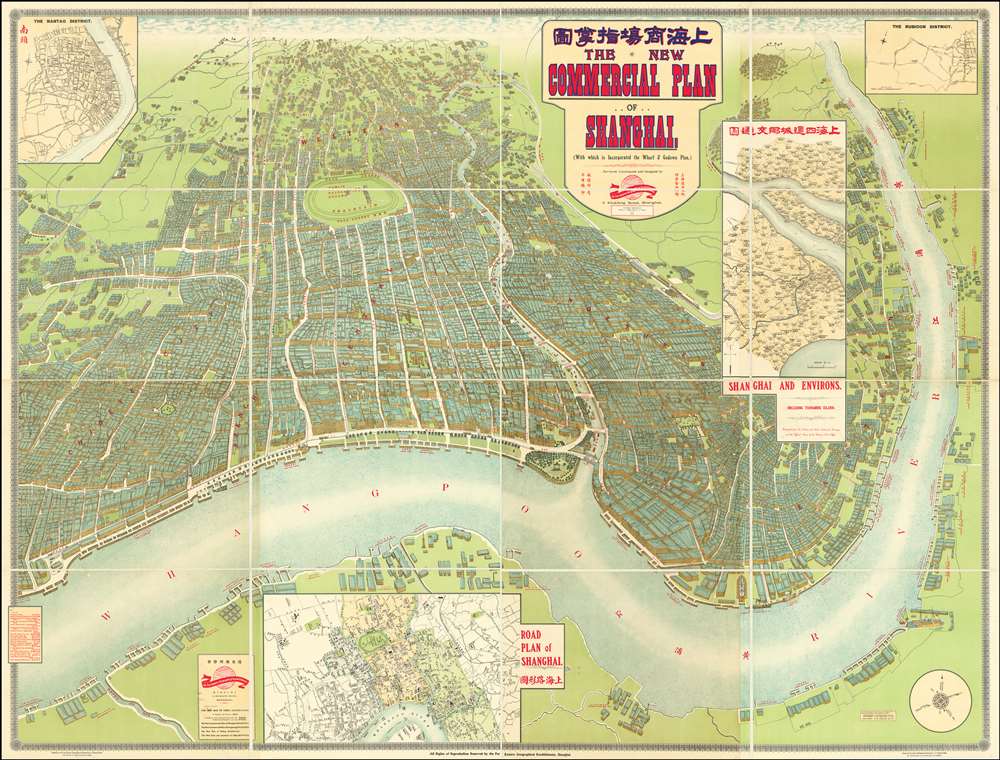
The New Commercial Plan of Shanghai (with which is incorporated the Wharf and Godown Plan). Surveyed, constructed and designed by the Far Eastern Geographical Establishment 6 Kiukiang Road Shanghai.
1915 (dated) 63 x 83 in (160.02 x 210.82 cm)
1915 (dated) 63 x 83 in (160.02 x 210.82 cm)
Description
The greatest and most impressive map of Shanghai we have yet seen. Issued in 1915, this is the Far Eastern Geographical Establishment / Edwin John Dingle / H. J. Fruin pictorial view and map of Shanghai. The map is a staggering 83 x 63 inches. The view looks on Shanghai from the east, at a high point across the Huangpu River in what is today the hip Pudong district. In includes the Bund, the Shanghai International Settlement, and the British and French Concessions, as well as the old Chinese City at left. It was issued shortly after the shortly after the 1911 Xinhai Revolution. One can follow Wusong Creek westward into the Horizon, which is illustrated with clouds. Inset maps detail Shanghai and Environs, Road Plan of Shanghai, The Nantao District, and The Rubicon District.
Shanghai International Settlement
The Shanghai International settlement was created in 1863 when the British and American Shanghai enclaves merged. These concessions had been granted to England and the United States as part of the Unequal Treaties that followed the Opium Wars. From about 1854 the settlements were governed by the Shanghai Municipal Council, a British dominated board of government officials and powerful merchants. The board issued restrictions limiting Chinese habitation on International Settlement territory and oversaw the construction of public services, including Trams, a sewage system, highways, and port buildings. The International settlement expanded several times in the late 19th and early 20th century. It became an enclave of peace and prosperity when the Japanese invaded Shanghai in 1937 but this abruptly came to an end with the Japanese bombing of Pearl Harbor and subsequent invasion of the International Settlement in 1941. After the war the International Settlement lands were returned to Chinese sovereignty.Shanghai 1910 - 1932
The 1910s-20s were a golden age for Shanghai. While China was ruled by Chiang Kai-shek, Shanghai was dominated by several consolidated foreign trade Concessions. Under the strict administrative control of the Concessions, the city became a cosmopolitan haven in the midst of political unrest and a center for global trade and finance. The Concessions occupied what is today central Shanghai's most desirable land, hugging the Huangpu River and Wusong River (Suzhou Creek). These extraterritorial European, Japanese, and American enclaves had elegant housing, fine roads, streetcars, elegant shops, clubs, and more. It was a place of excess, art, and extravagance, where fortunes could be made by the enterprising - and lost by the foolish. Moreover, lacking the moral constrains that limited social life in Europe and America, Shanghai became nexus for the opium trade, sexual excess, gambling, and other vices. This ephemeral world come crashing down on January 28, 1932, when the Shanghai Incident or January 28 Incident pitted the Republic of China against the Empire of Japan. Responding to Chinese student protests against the Japanese occupation of Manchuria, the Japanese Navy bombarded Shanghai. Chiang Kai-shek sent the Chinese army in to defend the Shanghai students, threatening to escalate the conflict. The League of Nations, fearing all-out war, united to demand a ceasefire, which was signed. Nonetheless, most consider The January 28 incident to be the opening salvo of the Second Sino-Japanese War (1938 - 1945) which ultimately merged into World War II.Publication History and Census
Published Edwin John Dingle and H. J. Fruin. Issued by the Far Eastern Geographical Establishment and printed by China Publishing and Printing. We are aware of only 2 known examples, both in institutional collections (Cornell University and University of Wisconsin, Milwaukee/American Geographical Society Collection).Cartographer
Edwin John Dingle (April 6, 1881 - January 28, 1972) was an English journalist, publisher, author, and mystical guru. Dingle was born in Cornwall but orphaned at just 9. He studied to become a journalist, moving to Singapore in 1900 to cover the Far East. He traveled extensively in China and was involved with the early days of publishing in Shanghai. From Shanghai and Singapore, he also published several early maps of China, Shanghai, the The New Atlas and Commercial Gazetteer of China, and several books on the history of China. In 1910, Dingle traveled to Tibet, where he reportedly studied under a Tibetan 'spiritual master' and Lama. On his return from Tibet, he witnessed the 1911 Xinhai Revolution, observing events in both Wuhan and Shanghai, as well as the brutal attacks on Hankou and Hanyang. After some 21 years in China, Dingle relocated to Oakland California, where he lived in seclusion meditating and practicing his own version of Pranayama in pursuit of mystical powers, extrasensory perception, and spiritual development. There Dingle founded the Institute of Mentalphysics in 1933-34, styling himself President and Preceptor Emeritus. The institute was well financed and hired the famed architect Frank Lloyd Wright to design a near 400-acre campus in Joshua Tree. At the institute he called himself by his adopted Chinese name, Ding Le Mei (丁乐梅). Dingle died in 1972 in California. More by this mapmaker...
Condition
Very good. Folds into original binder. Linen backing.
References
OCLC 62677469.