Digital Image: 1934 Jih-Sin Geographical Institute Map of Shanghai, China
Shanghai-jihsingeographical-1934_d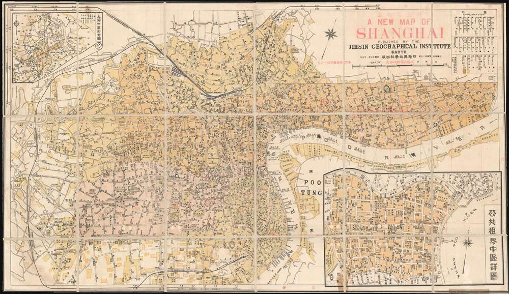

Title
A New Map of Shanghai. / 新上海地圖
1934 (dated) 17.5 x 30.25 in (44.45 x 76.835 cm) 1 : 20000
1934 (dated) 17.5 x 30.25 in (44.45 x 76.835 cm) 1 : 20000
Description
FOR THE ORIGINAL ANTIQUE MAP, WITH HISTORICAL ANALYSIS, CLICK HERE.
Digital Map Information
Geographicus maintains an archive of high-resolution rare map scans. We scan our maps at 300 DPI or higher, with newer images being 600 DPI, (either TIFF or JPEG, depending on when the scan was done) which is most cases in suitable for enlargement and printing.
Delivery
Once you purchase our digital scan service, you will receive a download link via email - usually within seconds. Digital orders are delivered as ZIP files, an industry standard file compression protocol that any computer should be able to unpack. Some of our files are very large, and can take some time to download. Most files are saved into your computer's 'Downloads' folder. All delivery is electronic. No physical product is shipped.
Credit and Scope of Use
You can use your digial image any way you want! Our digital images are unrestricted by copyright and can be used, modified, and published freely. The textual description that accompanies the original antique map is not included in the sale of digital images and remains protected by copyright. That said, we put significant care and effort into scanning and editing these maps, and we’d appreciate a credit when possible. Should you wish to credit us, please use the following credit line:
Courtesy of Geographicus Rare Antique Maps (https://www.geographicus.com).
How Large Can I Print?
In general, at 300 DPI, you should at least be able to double the size of the actual image, more so with our 600 DPI images. So, if the original was 10 x 12 inches, you can print at 20 x 24 inches, without quality loss. If your display requirements can accommodate some loss in image quality, you can make it even larger. That being said, no quality of scan will allow you to blow up at 10 x 12 inch map to wall size without significant quality loss. For more information, it is best consult a printer or reprographics specialist.
Refunds
If the high resolution image you ordered is unavailable, we will fully refund your purchase. Otherwise, digital images scans are a service, not a tangible product, and cannot be returned or refunded once the download link is used.
Cartographer
Su Jiarong (蘇甲榮; 1895 - 1946), also known as Soo Chia-yung, was a Kuomintang aligned Han Chinese geographer active in Shanghai in the early 20th century. He was born in Tengyun, Kwangsi, China (Guangxi, China) in 1895. Jiarong first studied at the Fujicheng Private School and the Sanxiang School, before being admitted to the Wuhan Middle School. In 1914, he joined a special program to study English at the National Peking University Preparatory School. From 1917 he studied at Beida, the Peking Government University where he received a degree in philosophy and did considerable geographical work. While in college he founded the magazine, China Youth Monthly (少年中國月刊). After graduating he served as secretary of the Peking Government University and Secretary of the Peasants' Department of the Central Executive Committee of the Kuomintang. He was later a professor of history and geography at the Wuhan National University. During the Northern Expedition of the National Revolutionary Army he was secretary to the 8th Nationalist Revolutionary Army, and chief secretary to the Headquarters of the Commander-in-Chief of the 15th Route Nationalist Army. Jiarong served the KMT as expert member of the Committee for the Study and Revision of Maps and Charts organized by the Ministries of Interior, Navy, Education and Foreign Affairs and the Headquarters of the General Staff and the Mongolian - Tibetan Affairs Commission. He then transitioned to private publishing as the founder and director of the Shanghai-based Jih-Sin Geographical Institute. Having lived through years of Japanese aggression in China, his work is notable for being Anti-Japanese and often included detailed descriptions of war crimes. During the Japanese invasion of China during World War II, many of his maps were rounded up by Japanese forces and destroyed for their anti-Japanese content - making them exceptionally rare and desirable today. On the July 11, 1944 (Minguo 33), he was arrested in Shanghai by Japanese military police and consigned to the infamous Ward Road Gaol. He was subsequently tortured until he died in January 1946 (Minguo 35). More by this mapmaker...