This item has been sold, but you can get on the Waitlist to be notified if another example becomes available, or purchase a digital scan.
1934 Jih-Sin Geographical Institute Map of Shanghai, China
Shanghai-jihsingeographical-1934$700.00

Title
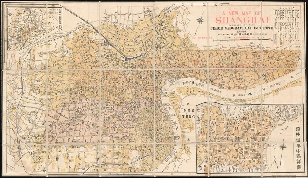
A New Map of Shanghai. / 新上海地圖
1934 (dated) 17.5 x 30.25 in (44.45 x 76.835 cm) 1 : 20000
1934 (dated) 17.5 x 30.25 in (44.45 x 76.835 cm) 1 : 20000
Description
This is a rare Minguo 23 or 1934 bi-lingual map of pre-war Shanghai issued by the Chinese KMT Nationalist geographer Su Jiarong of the Jih-Sin Geographical Institute. Centered on the Bund, the map covers the International Settlement, the French Concession, the old Chinese City, and parts of NanTao and Pudong. Su Jiarong, the map's author, was a prominent Chinese book and map publisher in Shanghai whose anti-Japanese publications were aggressively collected and destroyed during the Japanese occupation of Shanghai (1937 - 1945), making his works exceptionally rare today.
Lining the Huangpu River, the Shanghai Bund has dozens of historical buildings that once housed important banks and trading housing from the United Kingdom, France, United States, Italy, Russia, Germany, Japan, Netherlands and Belgium, as well as the consulates of Russia and Britain, a newspaper, the Shanghai Club and the Masonic Club. The Bund lies north of the old walled city of Shanghai and was initially a British settlement. A building boom at the end of the 19th century and the beginning of the 20th century led to the Bund becoming the major financial hub of East Asia. The former French Bund, east of the walled city was formerly more a working harbor.
Manuscript Highlights of War Road Goal
In the Japanese controlled Hongkou district, the location of Tilanqiao Prison (提篮桥监狱), then known as the Ward Road Gaol, is highlighted in manuscript. This prison was built in 1903 to hold those convicted of crimes in the British controlled International Settlement. Until 1941 it was predominately run by British and Indian officials and primarily housed Chinese prisoners. After this date, and the Japanese occupation of Shanghai, the prison was used by the Japanese military to house both civil and political prisoners. It is of interest that in 1944, after this map's author, Su Jiarong, was arrested by Japanese military police for his seditionist publications, he was consigned to this infamous prison, where two years later he died from torture. It is unclearly if the prison's highlighting is related to Jiarong's imprisonment, or other factors.Shanghai International Settlement
The Shanghai International Settlement was created in 1863 when the British and American Shanghai enclaves merged. These concessions had been granted to England and the United States as part of the Unequal Treaties that followed the Opium Wars. From about 1854 the settlements were governed by the Shanghai Municipal Council, a British dominated board of government officials and powerful merchants. The board issued restrictions limiting Chinese habitation on International Settlement territory and oversaw the construction of public services, including trams, a sewage system, highways, and port buildings. The International Settlement expanded several times in the late 19th and early 20th century. In addition, they constructed and administered Extra-Settlement Roads into the surrounding country, which further allowed for informal expansion. It became an enclave of peace and prosperity when the Japanese invaded Shanghai in 1937 but this abruptly came to an end with the Japanese bombing of Pearl Harbor and subsequent invasion of the International Settlement in 1941. After the war the International Settlement lands were returned to Chinese sovereignty.Shanghai French Concession - 上海法租界
On April 6, 1849, Lin Kouei (麟桂), the Chinese governor of Shanghai, granted French Consul Charles de Montigny (1805 - 1868) a proclamation ceding extraterritoriality to France in order to establish a trading colony. The Concession initially occupied a narrow collar of land around the northern end of the Chinese City, south of the British settlement, an area of 66 hectares. It was subsequently expended several times. A further small strip of riverside land to the east of the Chinese City was added in 1861, to allow for the Quai de France, docks servicing shipping between China and France. Between 1899 and 1900 the French Concession further expanded, nearly doubling in size with new territory extending west of the original grant. It expanded again in 1914, reaching as far west as modern Huashan Lu (Avneue Haig). By the 1920s, the western part of the French Concession had become the most desirable residential area of Shanghai, popular both with foreign nationals and wealthy Chinese. The concession was mistakenly bombed during the chaotic 1937 Battle of Shanghai, fought between the National Revolutionary Army (NRA) of the Republic of China (ROC) and the Imperial Japanese Army (IJA). In 1943, the French Concession was handed over to the Japanese puppet Wang Jingwei Regime by Vichy France. The turnover was officially ratified after the war by the Sino-French Accord of February 1946, signed by the French Ambassador and Chiang Kai-shek. Today the French Concession, with its tree lined boulevards and French colonial architecture, remains Shanghai's most desirable neighborhood.The Bund
The Bund is a waterfront area in central Shanghai. The name is derived from the old German term, 'bund,' meaning simply embankment or causeway. Many Asian colonial cities supported a Bund, but none became more famous or iconic than the Shanghai Bund. The area centers on the section of Zhongshan Road within the former Shanghai International Settlement, which runs along the western bank of the Huangpu River, facing Pudong, in the eastern part of Huangpu District. The Bund usually refers to the buildings and wharves on this section of the road, as well as some adjacent area. It is one of the most famous tourist destinations in Shanghai and a designated historic zone.Lining the Huangpu River, the Shanghai Bund has dozens of historical buildings that once housed important banks and trading housing from the United Kingdom, France, United States, Italy, Russia, Germany, Japan, Netherlands and Belgium, as well as the consulates of Russia and Britain, a newspaper, the Shanghai Club and the Masonic Club. The Bund lies north of the old walled city of Shanghai and was initially a British settlement. A building boom at the end of the 19th century and the beginning of the 20th century led to the Bund becoming the major financial hub of East Asia. The former French Bund, east of the walled city was formerly more a working harbor.
Publication History and Census
Variations of the is map were published in multiple editions until about 1949. The map was compiled by the Chinese geographer Su Jiarong (Soo Chia-yung, 蘇甲榮), and as such is one of the few Chinese-published maps of Shanghai to emerge from the concession period. Su Jiarong was a prominent Chinese book and map publisher in Shanghai whose anti-Japanese publications were aggressively collected and destroyed during the Japanese occupation of Shanghai (1937 - 1945). All of his maps are consequently extremely rare today.Cartographer
Su Jiarong (蘇甲榮; 1895 - 1946), also known as Soo Chia-yung, was a Kuomintang aligned Han Chinese geographer active in Shanghai in the early 20th century. He was born in Tengyun, Kwangsi, China (Guangxi, China) in 1895. Jiarong first studied at the Fujicheng Private School and the Sanxiang School, before being admitted to the Wuhan Middle School. In 1914, he joined a special program to study English at the National Peking University Preparatory School. From 1917 he studied at Beida, the Peking Government University where he received a degree in philosophy and did considerable geographical work. While in college he founded the magazine, China Youth Monthly (少年中國月刊). After graduating he served as secretary of the Peking Government University and Secretary of the Peasants' Department of the Central Executive Committee of the Kuomintang. He was later a professor of history and geography at the Wuhan National University. During the Northern Expedition of the National Revolutionary Army he was secretary to the 8th Nationalist Revolutionary Army, and chief secretary to the Headquarters of the Commander-in-Chief of the 15th Route Nationalist Army. Jiarong served the KMT as expert member of the Committee for the Study and Revision of Maps and Charts organized by the Ministries of Interior, Navy, Education and Foreign Affairs and the Headquarters of the General Staff and the Mongolian - Tibetan Affairs Commission. He then transitioned to private publishing as the founder and director of the Shanghai-based Jih-Sin Geographical Institute. Having lived through years of Japanese aggression in China, his work is notable for being Anti-Japanese and often included detailed descriptions of war crimes. During the Japanese invasion of China during World War II, many of his maps were rounded up by Japanese forces and destroyed for their anti-Japanese content - making them exceptionally rare and desirable today. On the July 11, 1944 (Minguo 33), he was arrested in Shanghai by Japanese military police and consigned to the infamous Ward Road Gaol. He was subsequently tortured until he died in January 1946 (Minguo 35). More by this mapmaker...
Condition
Good. Dissected and mounted on old linen. Some edges trimmed. Minor discolorations to lower border.